crossbowftw3
-
Posts
1,394 -
Joined
-
Last visited
Content Type
Profiles
Blogs
Forums
American Weather
Media Demo
Store
Gallery
Everything posted by crossbowftw3
-
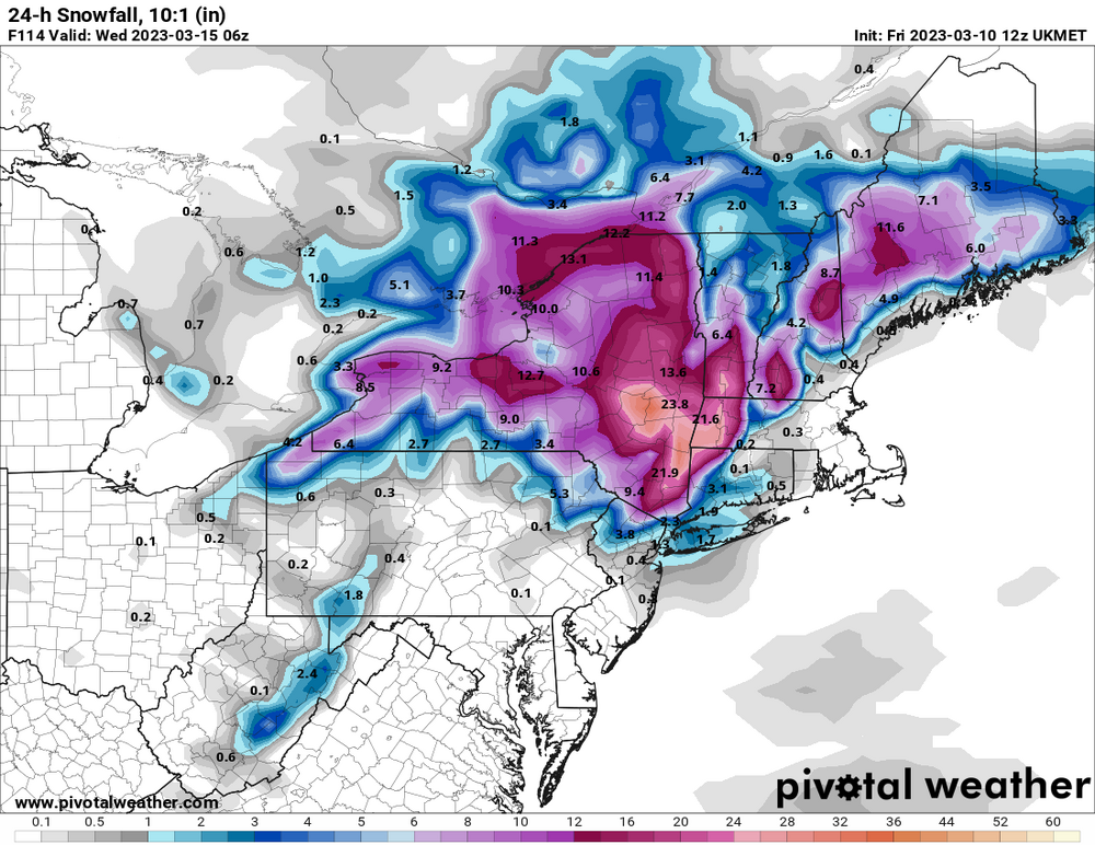
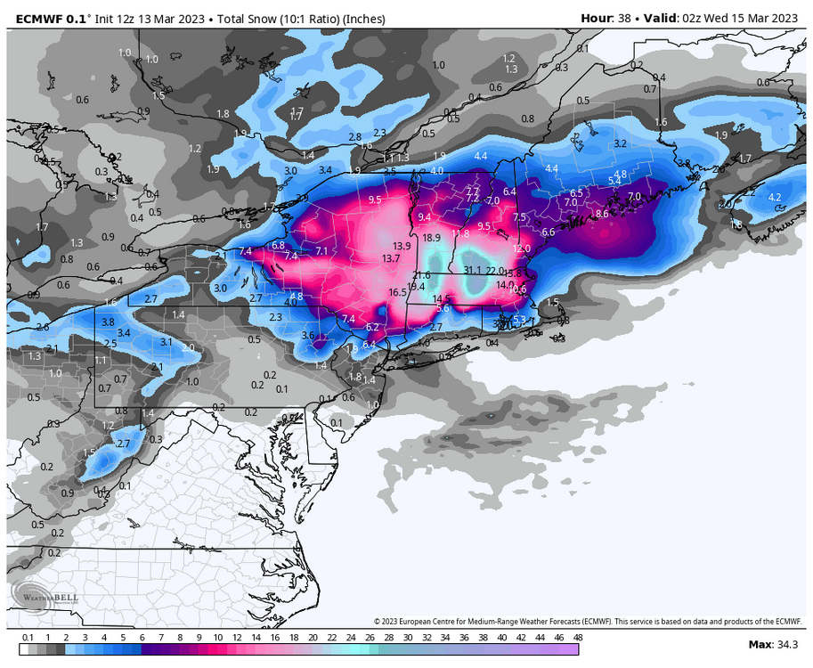
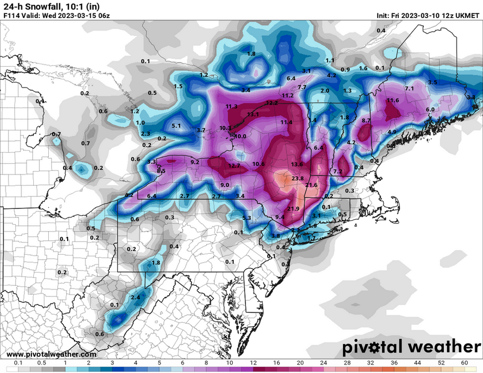
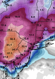
Euro looks no better, NWS offices probably scrambling to figure out what exactly they should be doing for these afternoon packages Too far southwest and low elevation for the real goods for me
-
I would still say 6-12 for me in Sullivan one county north of you both but I would now believe 6-9” would be more common than the 9-12”
-
Looks like the last minute reversals back east are happening, pretty standard fare now for this winter At least up here should still see 6-12 I would think
-
…like the new GFS that takes me down to 6”, but delivers a 3’ jack to Greene County Roadtrip?
-
Still no real certainty despite watches flying now. 8-18” under this watch, but seeing the east camp runs hang on is enough to give pause. We’re still seeing snow regardless, how much continues to shift and change from run to run. In all cases I need to get to at least Hunter elevation to see the real goods
-
Not at all a slam dunk for those of us even up here. 8-18, sure, but 18 would be confined to the high elevations, unless the eastern camps win out and leave even us somewhat high and dry. So many moving, confusing parts of this whole evolution
-
Looks like I barely saw 3-4” while MSV area picked up anywhere from 6-8”. Power actually went twice this morning for brief periods and there are a shockingly not zero number of outages around, spells trouble wherever the absolutely heaviest snows are Monday-Tuesday
-
Starting to look like a close shave for me in western Sullivan which has got me feeling somewhat on edge I’ve had my day in the light with these big storms, and also some painful close calls, in a winter like this it would only be fitting for the one of the last big chances to end up in some kind of whiff/missed potential for even deeper inland folks like myself
-
Imagine going from that .2 in Massachusetts to 2’ in the matter of not even 50-60 miles
-
Congrats Berks on the opening 12z runs
-
From main thread + euro lala land but six years to the exact day would just be too funny of a coincidence
-
2-4 followed by a pinger blast looks pretty locked in by this point, the chatter around next weekend takes me back to around the time of the Pi Day 2017 blizzard, still one of the nuttiest storms I’ve ever personally witnessed. Solid 1-2” an hour for 15 hours left behind 27” at my house and I still swear there was a point that morning when it snowed briefly at 4-6” an hour
-
Approximately 6.5-7” and with some snow still ongoing I could squeeze out another 1” or so through the day
-
Should be a very easy 5-8” event up in Sullivan. For the third time this winter and first since the middle of December I’m going to get my snowblower fired up
-
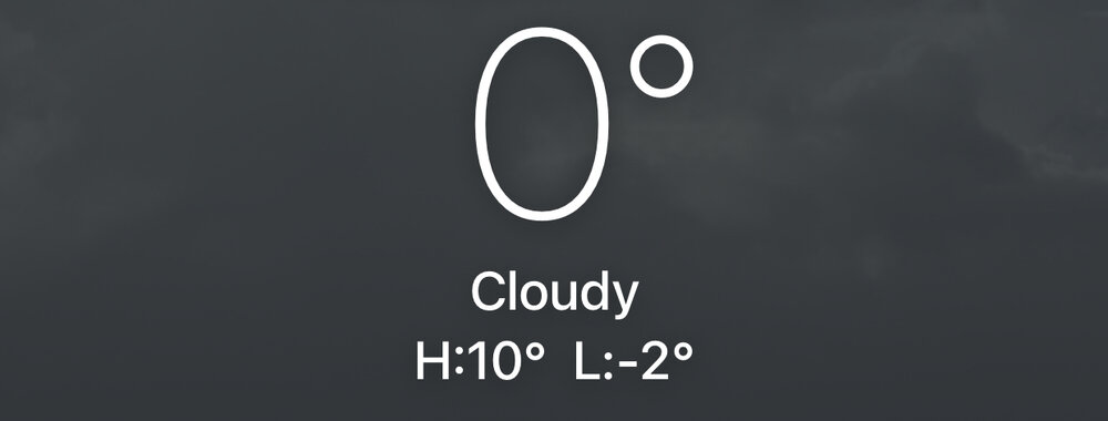
Bottomed out at -6, now 3 above
-
Snow kicked off in earnest about 40 minutes ago, coming down at a solid rate already. Each successive HRRR run in the last few hours jacked the snow back up a tad, of course no longer see 6+ aside from isolated instances at elevation but 3-6 still a safe bet before the flip
-
Feel like the warning now shouldn’t be in place as NAM has, of course, back even further off while RAP is basically all on its own in disseminating the band still being in play
-
750-800’ in SW Sullivan right on the Delaware with PA basically right there
-
New NAM would be nice, but not probable. Would deliver most of the thump with >10:1 (at least north of 84) and ending result is a much wider area of 5-8” with some 10” spots
-
Already set up with a WSWatch for 5-8 before the change happens. Gotta hedge lower for me since elevation, but at least it’ll be something to close the month with. Likely running at least 1-1.5’ below normals for this point of the season
-
Folks like @snywxand I may sneak in an advisory event with Sunday-Monday, but if I want to find the highest totals I probably need to go to at least 1k+, not sure how much that’d matter especially if it could just get all washed away come Wednesday
-
The bottom has fallen out. Can you believe we’ll see 50s again by the end of next week?
-
Meanwhile we’re all technically at lower pressures than the 70 MPH gusting, intense snowfall Buffalo lol
-
December 22nd - 23rd Cutter Discussion and Observations
crossbowftw3 replied to NJwx85's topic in New York City Metro
Meanwhile…. MSV AND Central Park have a lower pressure than Buffalo at this time which is crazy (both at 982.6)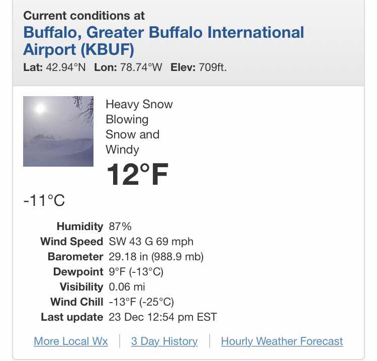
-
December 22nd - 23rd Cutter Discussion and Observations
crossbowftw3 replied to NJwx85's topic in New York City Metro
31.3, obs to my west peg temps there at 26. Temp tumble happening at a steady rate.