Kmlwx
-
Posts
13,205 -
Joined
-
Last visited
Content Type
Profiles
Blogs
Forums
American Weather
Media Demo
Store
Gallery
Everything posted by Kmlwx
-
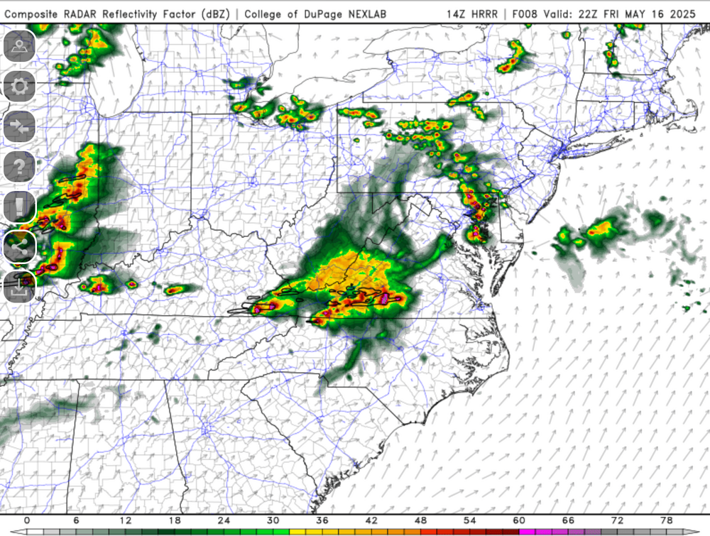
Sends a UH swath right through Charles County.....
-
CSU doesn't like the threat...but CIPS is honking nicely.
-
It's been pretty uneventful this year in our area in the severe department. I might have to stop using the WxWatcher007 blanket....it might actually be a curse.
- 1,281 replies
-
- 3
-

-

-
- severe
- thunderstorms
- (and 2 more)
-
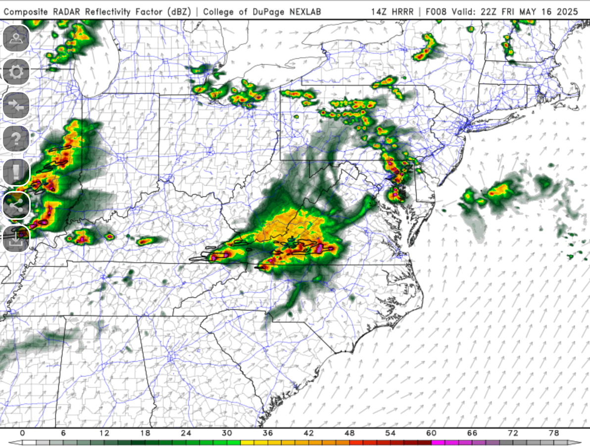
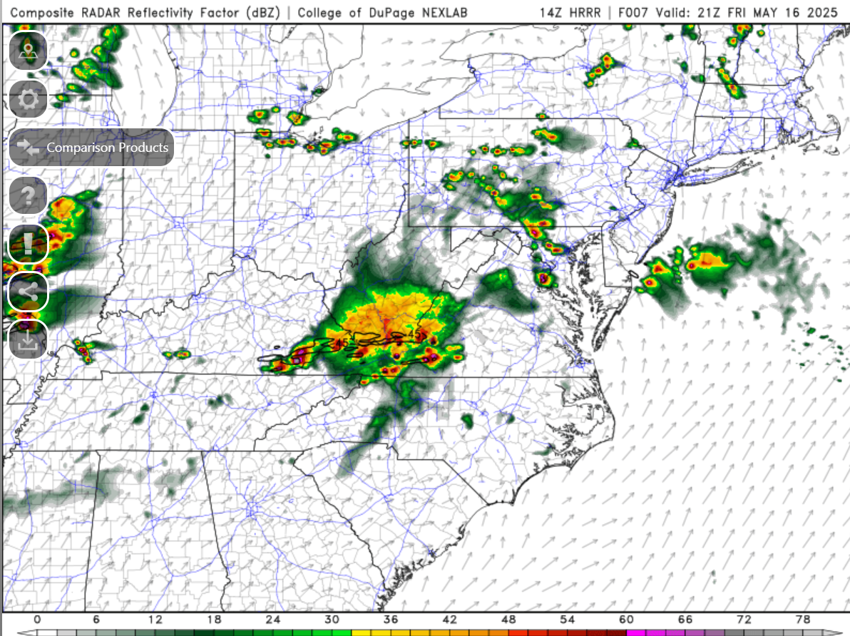
The 0z HRRR is pretty much a dud the rest of the night.
-
Mesoanalysis show a minimum of CAPE over most of the region. I just wonder if between the MLLR to the west potentially advecting in, and any "recovery" from any other processes overnight could sustain convection into our area. But judging my CAPE alone - it seems we are cooked for surface based activity. Perhaps the MLLR and better forcing and maybe if there's a cold pool fro the activity to the west could sustain covection. Lots of question marks.
-
Seems like a mixture of both.
- 1,281 replies
-
- 1
-
-
- severe
- thunderstorms
- (and 2 more)
-
HRRR fires storms in the 3am timeframe.
-
It honestly might miss MBY to the north - but yes it looks fierce!
-
Torrential rain with the MoCo cell that just went through. Nothing noteworthy otherwise. Thinking that if the next line holds up and doens't run out of gas it will be more intense.
-
The northern cell is still the more intense one it seems like. We'll see how this goes once they get some distance between each other.
-
Definitely not as intense but it definitely is a clean split now on radar!
-
The Loudoun cell looks like it might be splitting or bowing out.
-
I thought they might go higher on the hail in that MCD. Still seems like they are a bit uncertain about the ultimate outcome.
-
Clouds are moving in from the west. That could be a wrinkle to things...or it could provide a focus for activity perhaps.
-
No changes for our area on the 1630z SPC D1 outlook. I guess SPC still has big questions about initiation and coverage. The subsequent HRRR runs will be interesting to see if they keep that trend of convecting in that afternoon timeframe.
- 1,281 replies
-
- 1
-
-
- severe
- thunderstorms
- (and 2 more)
-
My gut feeling says no with so many funding cuts. But we are the DC area...so who knows. The more boundaries the merrier! Shows clear as day on LWX coming south.
-
It's definitely fueled up out there. Would be a good day for a special 18z sounding... Sitting at 84 degrees and dew of 74ish but I think it's running a bit high. It's been bouncing between 72 and 75 on my PWS.
-
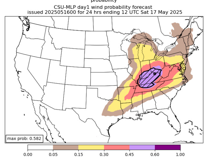
Also of note - overnight CSU MLP wind graphic put the red over us.
- 1,281 replies
-
- 4
-
-
- severe
- thunderstorms
- (and 2 more)
-
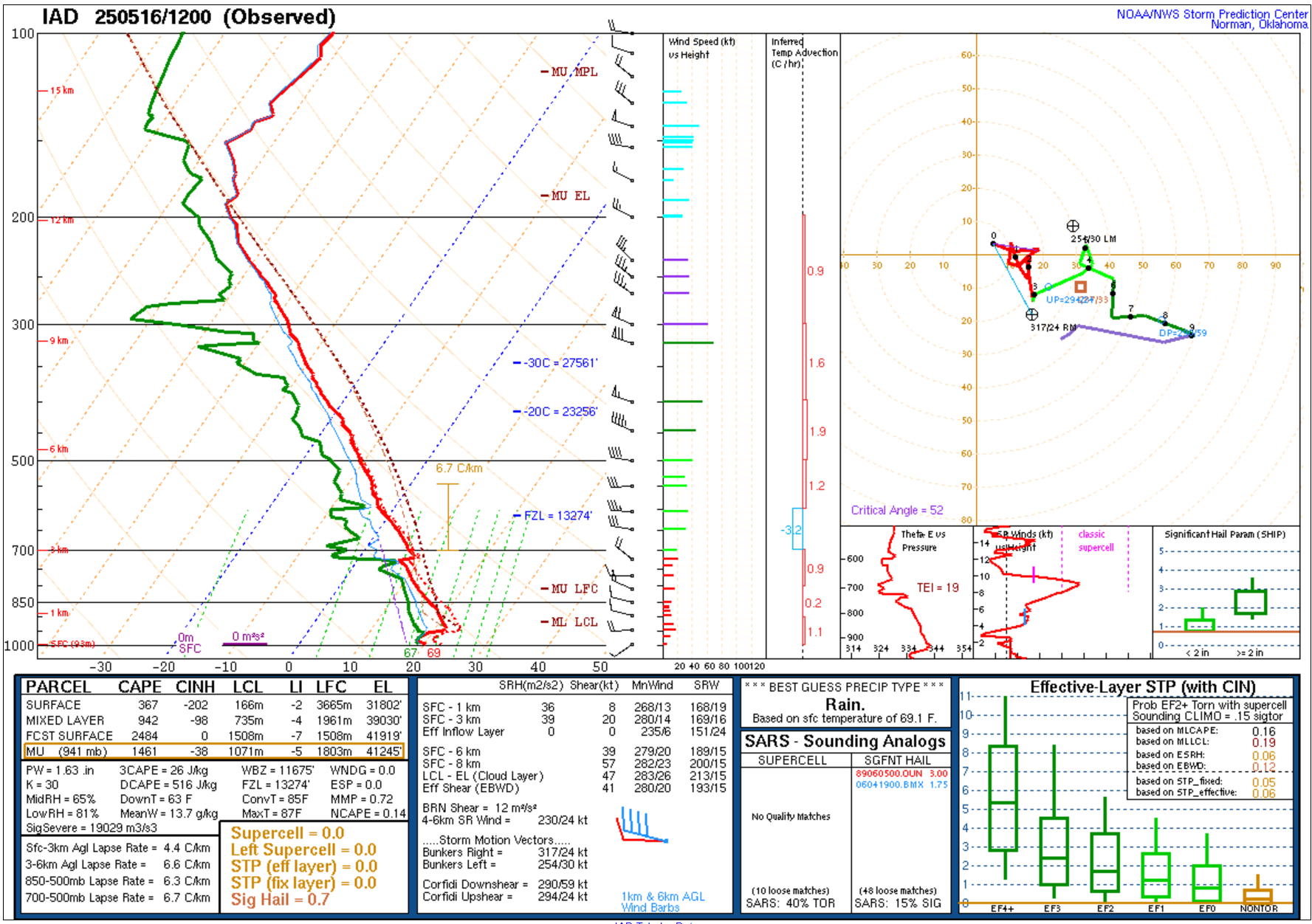
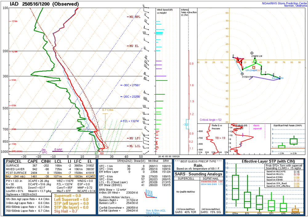
12z sounding from IAD/LWX
-
Many of the CAMS really are not enthused about the overnight stuff locally - perhaps for southern portions of the area. That will be interesting to see if they are correct.
-
- 1,281 replies
-
- 3
-
-
- severe
- thunderstorms
- (and 2 more)
-

- 1,281 replies
-
- 2
-
-
- severe
- thunderstorms
- (and 2 more)
-
Nice little cell to start the day is passing just to my north along the MC/HC line. Hopefully we clear out and don't deal with remnant clouds all day. Satellite behind this stuff looks fine. Places that get a little precip (even if not storms) could "benefit" for storm chances later via the additional moisture on the ground for higher dewpoints.
- 1,281 replies
-
- 1
-
-
- severe
- thunderstorms
- (and 2 more)
-
I'm yet again spam posting...but this thread isn't generally SUPER active so who cares I think if that MCS up in PA can "die" or fade out somewhat near the area - it could spit out/lay down some boundaries to aid in the less clear forcing for later on. Then it will be a question of seeing if the cap holds, or if we can get some isolated activity to pop in the region. The other possibility is (as we've discussed already) - that the upstream convection from the moderate risk could surge through some part of the area later on tonight. Similar to winter...the more chances that are presented - the better the odds of at least one working out. We failed on the morning MCS this AM up in PA. Next we'll see if there's any afternoon initiation (maybe higher terrain?) and then the eyes will be on the overnight stuff. While NONE of these are certain to get any of us...I do think the highest overall odds would come with the MCS activity tonight from the west/SW. The question at that point would be whether it becomes elevated convection or remains surface based/severe.
- 1,281 replies
-
- 4
-
-

-
- severe
- thunderstorms
- (and 2 more)
-
One unscientific note on the MCS up in PA - previous model runs yesterday had that coming through shaped like a long NW-SE stretching "arm." In reality it looks like a reverse L shape. Had that horizontal part of the L been straight downward like in the prior model forecasts, it likely would have been a closer call for parts of our area. Let's see how the afternoon plays out in terms of instability etc. I'm not "out" but I have tempered my expectations until I see a legit/more certain threat.
- 1,281 replies
-
- 1
-
-
- severe
- thunderstorms
- (and 2 more)