

Kmlwx
-
Posts
13,597 -
Joined
-
Last visited
Content Type
Profiles
Blogs
Forums
American Weather
Media Demo
Store
Gallery
Everything posted by Kmlwx
-
Not saying it will happen, but every now and then a lower parameter day will surprise and out perform the prior day. Always fun because it just goes to prove microscale stuff sometimes just says F known science and does its own thing!
- 1,500 replies
-
- 3
-

-

-
- severe
- thunderstorms
- (and 7 more)
-
Could go either way. There will be storms... Just not sure the severity. CSU still likes today.
-
Really interesting storm movement yesterday too!
-
This will be tough with the iterations of drone regulations happening the past few years. Especially in the DC/Baltimore region (and even extending to Southern Maryland, and down to Virginia Beach. Some of the most heavily regulated air space in the world exists here - and the concentration of major military installations contributes of course. Between JB Andrews, the SFRA around DC, Pax River down in Southern Maryland, and one of our biggest naval areas down in Norfolk - any mass drone event probably would be a tough sell.
-
Well - for us weather weenies - we either can read velocity/radar or follow people that can. So I feel like we almost gauge severity on a scale that average Joe doesn't
- 1,500 replies
-
- 1
-
-
- severe
- thunderstorms
- (and 7 more)
-
Sub-severe so far in Odenton despite being under warnings. Still nice to get a bunch of good thunder though - and some cooling rain.
-
WoFS is spectacular! Insane how far modeling as come over the years!
-
Andddd the USAF fighters were nuts. Probably not going to see a concentrated air power demo before my time on this Earth runs out lol.
-
AFSOC was even better.
-
They went straight over me hauling ass and banking slightly to exit the city. Insane.
-
Yeah that should be a great photo op. Side note - the more isolated restrooms here look like sheds from a 1980s horror movie… So far security hasn’t hassled me thankfully.
-
I’m at the National Arboretum. Hoping I can maximize time here for the planes before convection fires. I’ve got no desire to get stuck here or inside the city when storms hit
-
I’m missing all the helicopters but my spot at the Arboretum has been outstanding for the fighters and heavier planes. Hoping convection holds off until I need to move before the grounds close
-
I'm heading out to the Nat'l Arboretum in a little while. I know I'll miss most of the rotary aircraft, but hoping as the bigger jets fly west to east I can get them as they edge ENE to exit the city to the east. Got some good pics yesterday from the Bowie area but the haze really screwed up the quality. Best solution for that is to get closer...Have no desire to head to the Mall in triple digit heat, though....plus the crowds. My backup spots are Costco in NE, Wegmans along US 50 in Maryland and then back to the park I was at yesterday. All strategic spots along 50 to be able to get out of dodge quickly if the storms start popping quick.
-
If you want a giggle - look at the NCAR AI site - https://www2.mmm.ucar.edu/projects/ncar_ensemble/ainwp/?fbclid=IwZXh0bgNhZW0CMTAAAR3_KcoSRHWhY1lxCTCfOqSNC0AD8SUSmL_c7R_N8rtpvo-PsNNvuY3vuI4_aem_Stpgx3ntIqB8IVErFY76cQ Looks like a nuke went off. Seems NCAR and CSU think today is the big show and tomorrow still a threat but less so. But that could just be since day 1 is here and now, and day 2 still has some uncertainty.
-
I was fairly surprised there wasn't one yet - but I guess owing to the uncertainty in how robust the storms will be.
-
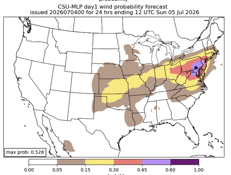
CSU MLP supports the 45%
- 1,500 replies
-
- 3
-
-
- severe
- thunderstorms
- (and 7 more)
-
Also the NAM seems to not do much Saturday but does have a major complex into the area Sun evening. GFS seems to like both days (severe TBD).
- 1,500 replies
-
- 3
-
-
- severe
- thunderstorms
- (and 7 more)
-
NCAR (always bullish) is VERY bullish for Saturday. CSU is pretty bullish for Saturday as well. I'm not at all in for any threat tomorrow. I think Sat/Sun could feature a substantial damaging wind threat IF there is a trigger and if storms can grow upscale (not just pulse, isolated crap)
- 1,500 replies
-
- 3
-
-
- severe
- thunderstorms
- (and 7 more)
-

Intermittent (but frequent) Bad Gateway 502 Errors
Kmlwx replied to Kmlwx's topic in Forum Information & Help
Thank you admin team! -
You monster.
-
I honestly think those folks on here that wish/hope for as hot as possible temps are nutty in a way that only they can be (and I mean this mostly lovingly). You can easily bundle up in cold....not really an "easy" way to not be drenched in sweat...
-
I'll bet you're glad you're retired from H20 work now!
-
No offense to average joes but the general public does not know or care about the difference between a flood and a flash flood. Might as well just say flood and call it a day. Only us weather weenies will understand the difference.
-
I guess we DO have weird squabbles outside of winter........sad.

