

ORH_wxman
-
Posts
93,092 -
Joined
-
Last visited
Content Type
Profiles
Blogs
Forums
American Weather
Media Demo
Store
Gallery
Everything posted by ORH_wxman
-
January 2026 regional war/obs/disco thread
ORH_wxman replied to Baroclinic Zone's topic in New England
The EPS would def be more favorable to us in the long range than the GEFS/GEPS. All 3 would offer plenty of chances with that look but the is more of a SE ridge flex on the GEFS/GEPS which we know the risks (and rewards) associated with that. I think the EPS would make it a little easier to sneak a coastal in there. -
January 2026 regional war/obs/disco thread
ORH_wxman replied to Baroclinic Zone's topic in New England
I always loved college football but I seem to mentally check out after new years. When they were making the BCS championship game on dates like Jan 4th or Jan 5th, they were still close enough for the wait. But now it’s NFL playoffs swallowing up the oxygen by the time they are playing for the national title now. And yeah…I’m sure it makes me sound like an old grouch. -
New Years Day 2026 - 1st snows of the new year possible
ORH_wxman replied to Baroclinic Zone's topic in New England
They can prob put it in maroon….it’s almost certain we avg AN during that 7 day period (the map says nothing about magnitude though) -
January 2026 regional war/obs/disco thread
ORH_wxman replied to Baroclinic Zone's topic in New England
30s over the interior when many of us are at double digits so far? It’s not like we’re all sitting at 4” like some of these other years. I do worry about the Niña February but we’ll see about the second half of this month. -
January 2026 regional war/obs/disco thread
ORH_wxman replied to Baroclinic Zone's topic in New England
They should’ve never gone past 4. But I get that they want the ratings. -
January 2026 regional war/obs/disco thread
ORH_wxman replied to Baroclinic Zone's topic in New England
Not sure it was “great” anywhere. Maybe near CT south shore they best snowfall climo by a decent amount due to 12/26-27. But pretty much everywhere else was normal to BN on snowfall despite the cold temps. But I’ll give December a little bump up in grade because the little snow we got stayed on the ground much of the month and we snuck in a white Xmas too. So it was a nice holiday feel. But all that is now mostly useless to me after new years so we better start getting some meatier storms. -
January 2026 regional war/obs/disco thread
ORH_wxman replied to Baroclinic Zone's topic in New England
Warming. Not warm. It gets pretty warm after 1/7 -
New Years Day 2026 - 1st snows of the new year possible
ORH_wxman replied to Baroclinic Zone's topic in New England
Wintry first sunset of the year.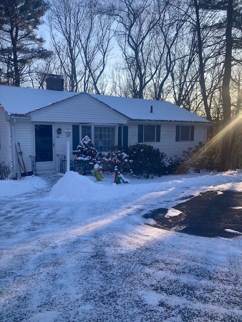
- 603 replies
-
- 10
-

-
New Years Day 2026 - 1st snows of the new year possible
ORH_wxman replied to Baroclinic Zone's topic in New England
Squalls were way more prolific than I would have thought. I’d expected maybe another half inch or something in the squalls, and instead it was like widespread 1-2” additional. To be fair though, 3-4” was still definitely in the minority of reports. But there were def a few more of them than I would’ve forecasted. -
January 2026 regional war/obs/disco thread
ORH_wxman replied to Baroclinic Zone's topic in New England
Hopefully today is more correct because that split flow +PNA look retrograding a little bit often does good things. -
New Years Day 2026 - 1st snows of the new year possible
ORH_wxman replied to Baroclinic Zone's topic in New England
Yeah south shore cleaned up on those squalls. BOS kind of got shafted being a little too far north but just south of them got crushed. -
January 2026 regional war/obs/disco thread
ORH_wxman replied to Baroclinic Zone's topic in New England
We could use them so we actually don’t finish another year BN in snowfall. Getting weakening overrunning systems and clippers won’t be sustainable for anyone who averages over about 40” per year. -
January 2026 regional war/obs/disco thread
ORH_wxman replied to Baroclinic Zone's topic in New England
EPS evolution D11-15 is pretty good actually. It’s not the most frigid but it’s good if you want to set up a pattern for more coastals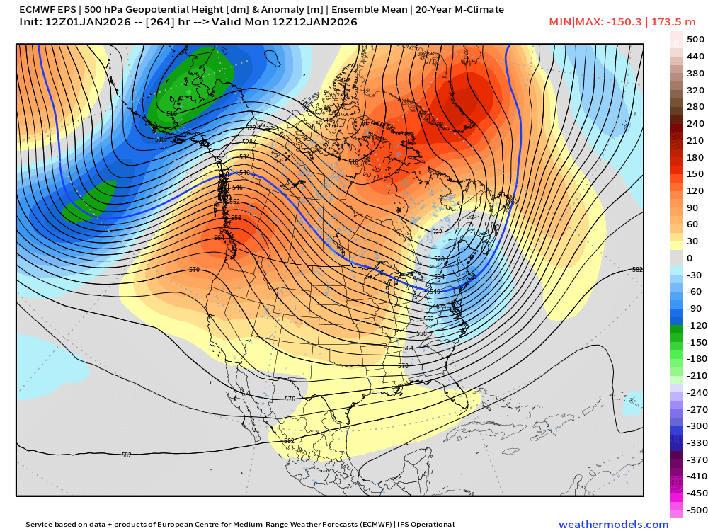
-
January 2026 regional war/obs/disco thread
ORH_wxman replied to Baroclinic Zone's topic in New England
EPS going with the OP in LR in really driving that PNA ridge up. That would bring in the chance for some coastals maybe in the 3rd week of the month. -
January 2026 regional war/obs/disco thread
ORH_wxman replied to Baroclinic Zone's topic in New England
Ensembles aren’t out yet…GEFS mostly out and they are kind of meh. OP euro decided to go cold post-1/11. -
January 2026 regional war/obs/disco thread
ORH_wxman replied to Baroclinic Zone's topic in New England
In everyone’s defense, these waves are pretty weak sauce. Not much upside. The 1/6 wave has the most upside imho if it can maintain enough integrity…better antecedent airmass too. But even that one prob has upside of like 3-5” and the reality is likely significantly less than that. Im more interested in the post-1/10 pattern evolution. Been a lot of variance on that. -
January 2026 regional war/obs/disco thread
ORH_wxman replied to Baroclinic Zone's topic in New England
There’s two different waves in there. GFS looked more robust snow-wise for 1/6 and then the follow up wave on 1/7-8 was kind of warm…but weak, almost really just a weak FROPA. Euro was weaker on 1/6 but a little colder on 1/7 and south which had a little shot of snow/ice with it. -
January 2026 regional war/obs/disco thread
ORH_wxman replied to Baroclinic Zone's topic in New England
Euro coming in colder for 1/7 also compared to 00z. Quick shot of snow/ice even into SNE. -
ORH was -4.8. Coldest since 2017. 2nd coldest (only behind 2017) since the frigid December 2000. 12.3” of snow was slightly BN. Respectable month but would’ve been better if we hit on another moderate event. Snow cover was good though. I think something like 25/31 days with cover.
-
New Years Day 2026 - 1st snows of the new year possible
ORH_wxman replied to Baroclinic Zone's topic in New England
That WINDEX event actually ended up being our demise in many ways over the next 7-10 days. It kept the 1/30/10 system well south of us (that was the one that looked like a big NC/S VA hit but trended into a big N VA/MD hit. Fluff bomb.) Then the vortex from that WINDEX event just spun to our northeast with the huge block in place and kept 2/5-6/10 south of us. -
January 2026 regional war/obs/disco thread
ORH_wxman replied to Baroclinic Zone's topic in New England
There’s not lot of evidence we’re going to stay near normal at least for the 1/7-1/11 period. People can quibble on the magnitude of the warmth but it’s going to be AN. After that is a little dicier. There’s a big shift going on in the PAC. Looks like PV tries to get reestablished near Hudson Bay which would be a return to a colder pattern. The question is how quickly that happens. Could be in place by 1/12-13 or it could wait a week. Or something different could pop up on guidance. Seems to be pretty good consensus right now though on ensemble guidance. -
New Years Day 2026 - 1st snows of the new year possible
ORH_wxman replied to Baroclinic Zone's topic in New England
Prob been since 1/28/10 since we had overperforming squalls this good down in SNE. That event was better in western and central areas whereas the squalls this time overperformed in east and southeast areas. -
New Years Day 2026 - 1st snows of the new year possible
ORH_wxman replied to Baroclinic Zone's topic in New England
@amarshall too. -
New Years Day 2026 - 1st snows of the new year possible
ORH_wxman replied to Baroclinic Zone's topic in New England
@SouthCoastMA must be getting crushed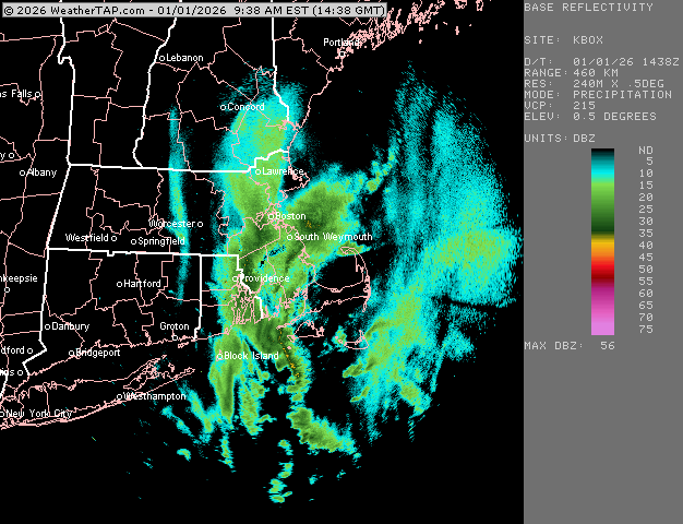
-
January 2026 regional war/obs/disco thread
ORH_wxman replied to Baroclinic Zone's topic in New England
Even if we have highs of something like low 40s over interior, that is pretty solidly above climo this time of year. We often measure our torches in how much the peak warmth is, but even if we don’t have any days of 50+, it will still be solidly AN for several days. If that system next weekend (around 1/10-1/11) ends up more CADish, then we could mute the warm departures somewhat but they will still be notable. If we warm sector in that system, we’ll make a run at 55+ easily.

