

ORH_wxman
-
Posts
93,099 -
Joined
-
Last visited
Content Type
Profiles
Blogs
Forums
American Weather
Media Demo
Store
Gallery
Everything posted by ORH_wxman
-
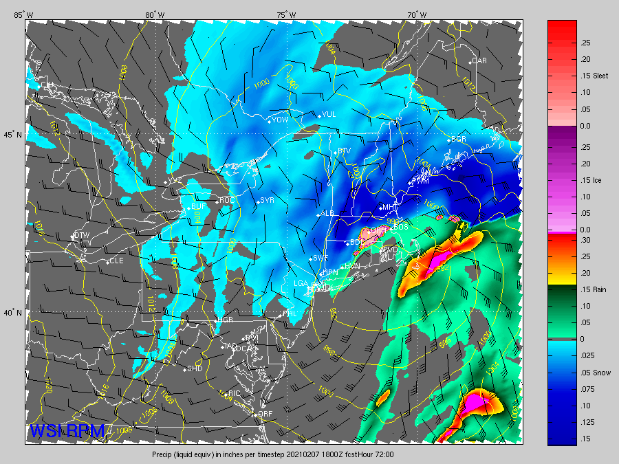
Little bit of phasing with northern stream at 33h right now...don't think they'll stay connected, but that helps pump heights up downstream.
-
Yeah they are almost the inverse-NOGAPS rule from years ago....you'd look at the NOGAPS back then and if it was pretty far NW, you knew that was kind of a red flag.
-
Looks to me like the 12z NAM is coming back north this run through 24 hours.
-
Not really....'nor is the RPM at this time range.
-
SREFs look like the RPM.
-
06z euro looked about the same as 00z. Was hoping for another bump NW there but it is still getting 1-2” across a lot of SNE with more over far SE areas.
-
06z GFS tickled NW. interesting set of trends in the last 12 hours. Some models going SE and others coming NW. Threat definitely still alive but need to narrow these goalposts.
-
Yep. Slightly less amped through 54h.
-
EPS a tick SE as well though there’s definitely still plenty of spread NW. We’re onto 00z.
-
Could be convection too. Convection is at a minimum around 12z and closer to maximum (or a little below maximum) at 00z. But that doesn’t explain all of it either. Esp in winter when there is less of it overall.
-
Yeah slight step back, still scraped the cape that run. OBviously need to reverse that trend at 00z. I actually thought really early on it looked better with the western trough axis a little west, but the southern vort ended up weaker and the northern stream pressed slightly more to offset that later on.
-
Euro coming in less amped this run. 12z was a scraper, so this might whiff.
-
GFS is gonna be west. Not like NAM but may hit SE areas pretty good this run.
-
ICON coming in a bit more amped again, though maybe not quite to the level of 06z run.
-
Moist Absolute Unstable Layer to be exact for the acronym letters.
-
RGEM is still mostly a whiff....clips the Cape and south coast.
-
Nice dryslot for eastern areas
-
NAM did pretty darn well actually with this past system. It was a bit too cold right on the coast if we're talking details, but it was surprisingly good with the synoptics.
-
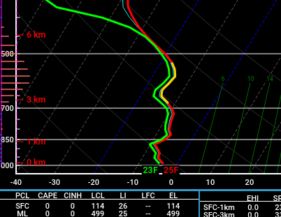
The SGZ issuper deep on the soundings.
-
It's more like over your fanny to ORH this run if we roughly pin it on top of the 600mb WF.
-
NAM is going to demolish SNE this run....that southern stream just went crazy.
-
Yep, that southern strema isreally strong this run, it might make up for the northern stream not digging as much early on. By 60h, it has made up most of the ground already it looks like.
-
Weeklies decided to finally punt on the idea of a warmup in late February. They are trying to torch March though.
-
Yeah the northern stream is fighting it this run...not digging quite as much.
-
Lol, I hot linked the 2nd image by accident....should be fixed now.


