

ORH_wxman
-
Posts
93,099 -
Joined
-
Last visited
Content Type
Profiles
Blogs
Forums
American Weather
Media Demo
Store
Gallery
Everything posted by ORH_wxman
-
Phew, now that we've seen the 87 hour SREFs, we can lock this storm in.
-
You could literally blow this stuff off the car with a hair dryer set on low.
-
Yeah that was a good improvement on 06z eps. This one has some life still.
-
Definite improvement on 06z euro. Still a whiff but way closer now. Actually not a total whiff, it does get an inch or two of snow into the cape.
-
Currently snowing with a couple tenths new.
-
Need a clear positive trend at 12z I think. We’re getting a bit short on time but can still bring it back if we trend it more right away. 06z NAM was closer too...brought a little light snow to far southeast areas on Sunday.
-
Still has the 2/9 system
-
Yes. But I’d put it fairly low right now. Too much CAD to have a true Rainer into all of NNE. Everything wound need to go right.
-
Next week is kind of a cluster on model guidance. I expect some decent shifts from run to run in how that PV and all the energy rotating around it is handled.
-
D6 looks like an overrunning snow/ice type threat....could morph into a Miller B, but it's certainly further north than previous threats.....makes sense as the block is further north by that point.
-
Goes nuts with that little vortmax out ahead of the main one....weird. Might produce some snow showers on Saturday night.
-
Megan said commuting down to Walpole was pretty crazy. They had like 6-7" of slop down there while it was buried here....she said most of the difference had already happened once in Medfield. That's like 6 miles the way the crow flies from here, lol. That area really got the shaft...usually Walpole/Foxoborough cleans up while a little to their east is suffering, but this time they didn't quite get on the right side of the gradient. They did ok, but way less than 10 miles NW of them.
-
Scooter is the dude throwing the computer while Bob is the dude asleep at the desk who has checked out on winter

-
Drive up to your office. I don't think Milford had quite as much as me, but still a foot or maybe a little more.
-
Scooter and NorEasterMass128 are in full 1/3/03 or 12/92 meltdown mode. They need a 2/7/03 to bring them back from the dead like that season.
-
Yeah its kind of a weak and northwest this run which basically just gives some warm sector showers to SNE and a little bit of snow to NNE, but the potential is there for sure for something more meaningful.
-
Ukie gone too...flat and out to sea.
-
ORH up to 55.4" now...sneaky solid total for 2/2. Them picking up nearly 10 inches in the 12/5 storm was a big boost that most other areas didn't see.
-
I think it would be hard to get a true cutter...there is a pretty stout Davis Strait/Baffin Island block. Can still happen if everything lines up perfectly but I'd def hedge colder. Even if it's icy/sleety overrunning mess.
-
2/9 seems like a much better threat for something...it will have a lot more room, but that also means potential for messier solutions as well. Both GGEM/GFS show precip in here. The antecedent airmass is pretty cold though so at leas that provides a little more wiggle room.
-
GGEM is well out to sea as well, though somehow it was an improvement over 00z.
-
Yes...the storms that go almost due north along 71W or so can hammer most of NE...or like a track NNE over the benchmark and into Bay of Fundy like dryslot said.
-
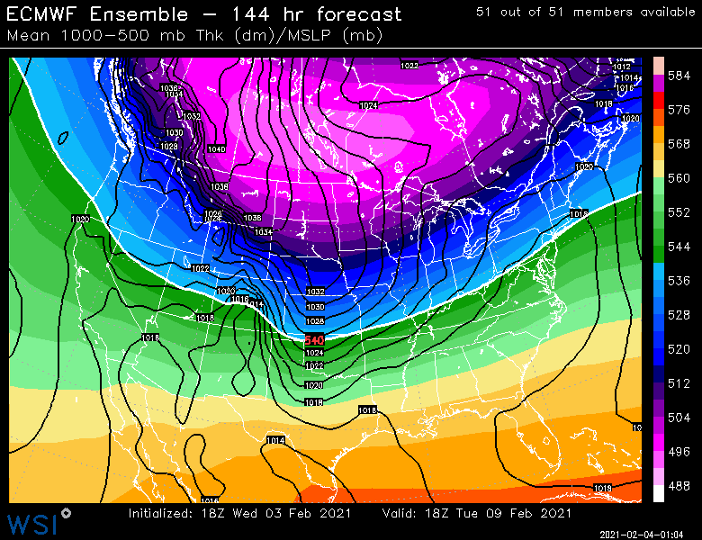
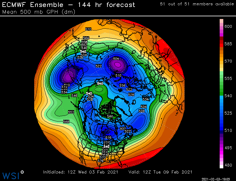
In order to get the bigger system Sunday, we need two pieces of energy....the northern stream is almost the arctic jet...it's that piece that comes down through Yukon and eventually into the lakes....the "southern stream" is actually the PJ piece that is still over in Kamchatka right now. Both of these pieces are in garbage coverage...esp the arctic jet piece since it's over the Arctic ocean right now and even satellite data there is distorted. Meridional pattern like that will often cuase model guidance to have large short term swings, so still worth watching.
-
Euro and EPS going way right is not a good sign....still time though to bring it back. There's another threat behind it too for 2/9-2/10
-
Yep...ASH was sucking on a little bit of exhaust from the CF enhancement to their east and the firehose wasn’t quite strong enough up at that latitude to overcome it. They still did ok, but relative min in the area.


