

ORH_wxman
-
Posts
93,092 -
Joined
-
Last visited
Content Type
Profiles
Blogs
Forums
American Weather
Media Demo
Store
Gallery
Everything posted by ORH_wxman
-
With a last gasp effort, winter 20-21 refuses to give up the ghost
ORH_wxman replied to moneypitmike's topic in New England
NAM actually has no snow at all now...maybe some flakes on the Cape? -
Yeah like 3/30-4/3 or so could produce a threat if that look holds.
-
With a last gasp effort, winter 20-21 refuses to give up the ghost
ORH_wxman replied to moneypitmike's topic in New England
I’d prob go 1-3” based on the overnight runs. The precip is moving out very quickly on those runs. We’ll see if it reverts back a bit on the 12z stuff but if not, then I’d be surprised if anyone got more than 3”. -
With a last gasp effort, winter 20-21 refuses to give up the ghost
ORH_wxman replied to moneypitmike's topic in New England
I was just going to comment how the off hour runs have consistently been pretty meh while the primary runs have jacked up amounts. -
With a last gasp effort, winter 20-21 refuses to give up the ghost
ORH_wxman replied to moneypitmike's topic in New England
Lol nice scooter jack on the rap. Not buying that distribution though. -
With a last gasp effort, winter 20-21 refuses to give up the ghost
ORH_wxman replied to moneypitmike's topic in New England
Assuming this doesn't all of the sudden get squashed SE ala 06z NAM, a good test will be to see where the snow line is around 03z tomorrow night...if it's already snowing around ORH up to your hood by 11pm, then it's prob game-on for at least solid advisory. But if we get to 1-2am and we're still screwing around with sleet/rain near the MA/NH border, then it's prob lower end. -
With a last gasp effort, winter 20-21 refuses to give up the ghost
ORH_wxman replied to moneypitmike's topic in New England
Yeah I'd prob cut the Euro 10 to 1 map in half. Not sure why Kuchie went wild....but I also don't think 8" in 5-6 hours is happening. I could maybe see 4-6 though where it snows very heavily for 3 hours. -
With a last gasp effort, winter 20-21 refuses to give up the ghost
ORH_wxman replied to moneypitmike's topic in New England
That was the NAM actually. It does collapse it SE...here is 09z.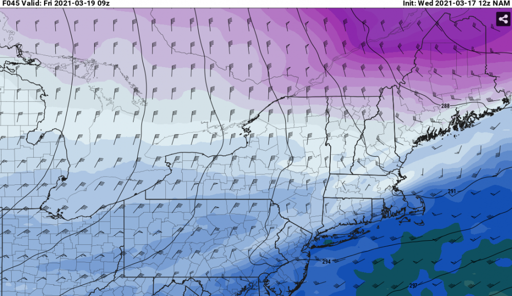
-
With a last gasp effort, winter 20-21 refuses to give up the ghost
ORH_wxman replied to moneypitmike's topic in New England
Here's 700 at 06z Friday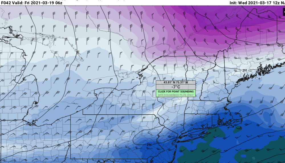
-
With a last gasp effort, winter 20-21 refuses to give up the ghost
ORH_wxman replied to moneypitmike's topic in New England
LOL V16 GFS goes insane with the band...it's only like 4-6 hours but it tries to drop 2" per hour. It is hard to buy those depictions, but can't rule out some pretty intense snow for a few hours if things break right. -
With a last gasp effort, winter 20-21 refuses to give up the ghost
ORH_wxman replied to moneypitmike's topic in New England
GFS juiced back up....not an easy forecast. -
With a last gasp effort, winter 20-21 refuses to give up the ghost
ORH_wxman replied to moneypitmike's topic in New England
That's a pretty sick band from the pike up into N MA border region. -
With a last gasp effort, winter 20-21 refuses to give up the ghost
ORH_wxman replied to moneypitmike's topic in New England
Yeah we haven't had hardly any of those this seasons. Your area to dryslot will often share the goods with SNE on some of those coastals...much moreso than NW New England near powderfreak/BTV. Even 12/17/20 struggled to really push north. It did get you to dryslot with some decent snow but the bulk was south...the storm kind of shunted due east once making it to a certain latitude. Some years like 2017-2018 or even 2014-2015 have a whole bunch of storms that have the SSW to NNE swath of snow that gets most everyone in the eastern 2/3rds of New England. -
With a last gasp effort, winter 20-21 refuses to give up the ghost
ORH_wxman replied to moneypitmike's topic in New England
It's very intense too for like 3-4 hours there...so if we're flipping to snow by midnight over interior, then it's going to produce a quick 5-6", but if it kind of waits until 2-3am, then it might just be a couple inches. Taking advantage of a couple extra hours of that really intense fronto will be key. -
With a last gasp effort, winter 20-21 refuses to give up the ghost
ORH_wxman replied to moneypitmike's topic in New England
18z NAM gone wild -
With a last gasp effort, winter 20-21 refuses to give up the ghost
ORH_wxman replied to moneypitmike's topic in New England
The fronto gets pretty strong on this....the biggest risk here is that there is about a 3-5 hour period of legit heavy snow with temps plummeting below freezing from mid/upper 30s rain just prior. So there could be a very fast 4-6" with a flash freeze....that's prob worst case scenario in this. Maybe somewhere in elevated W MA or N MA maybe sees something a little more than that, but not really buying 8"+ at this point. But even high end advisory snow with flash freeze is plenty bad on Friday morning. -
Wow, GFS is pretty impressive for Friday morning too. Further SE than the NAM, but it hits most of MA hard....Scooter jack?
-
RGEM is an impressive flash freeze widespread advisory snowfall event. Temps in the 20s during Friday as the snow lingers. Seems to get a lot of the forum eventually.
-
NAM gone wild N of the pike for late Thursday night/early Friday morning.
-
Yeah if the wind is really strong, then it will just shatter the dendrites as they fall and/or pack them pretty efficiently once on the ground so the ratios struggle. I may have had worse than 10 to 1....can't quite remember what the QPF was in that 14 inches but i imagine it was around 1.5" or so...maybe it was a little more. 8 to 1 wouldn't have surprised me. That pack was very durable.
-
Definite flash freeze potential. It takes some unique conditions to get a true flash freeze but this would have those conditions present as modeled right now.
-
3/14/17 was a solid event. Didn’t get the jackpot obviously (reserved for NNE and upstate NY) but that was crazy intense snow for about 5 hours. We picked up 14” here and most it fell in 5-6 hours. The sleet line barely made it here during the dryslot but it changed back to ugly snowflakes pretty quickly. Good QPF dump in that as the ratios were prob near 10 to 1. We had full snowpack until the end of the month that year and partial snowpack into the first week of April.
-
Gonna have to watch this sucker. If that ULL maintains integrity longer, it’s going to cause some bigger issues on Friday. It doesn’t take all that long for the cold air to get drawn in with that high pressing down. Also could enhance the fronto.
-
Thankfully, I think we have Kevin's PWS online now, right? So we can track his backyard where real people live.
-
I see mostly 30s and 40s this week. Maybe a low elevation 50+ spot on Thursday if lucky and clouds don't roll in early as Scooter said.


