

ORH_wxman
-
Posts
93,092 -
Joined
-
Last visited
Content Type
Profiles
Blogs
Forums
American Weather
Media Demo
Store
Gallery
Everything posted by ORH_wxman
-
Wednesday 12/8 Possible Snow/Ice/Rain? Discussion
ORH_wxman replied to Torch Tiger's topic in New England
Snowing pretty good here. Everything covered. About a quarter inch so far.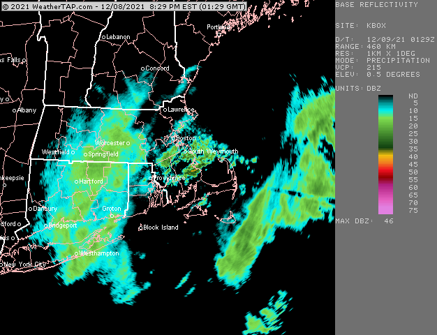
-
Wednesday 12/8 Possible Snow/Ice/Rain? Discussion
ORH_wxman replied to Torch Tiger's topic in New England
IVT becomes a bit more pronounced in the 9-10pm timeframe. That’s where we might see some enhancement of that lighter precip shield. You can see it pretty clearly on the modeled streamline analysis. -
December 2021 Obs/Disco...Dreaming of a White-Weenie Xmas
ORH_wxman replied to 40/70 Benchmark's topic in New England
Yeah seeing a +20 or -20 day in the summer is much harder than in the winter. In the winter, we can have a high of 0 or 5F or a high of 65-70F. In the summer your extremes are probably 55F to 100F for most of the area for highs. -
Wednesday 12/8 Possible Snow/Ice/Rain? Discussion
ORH_wxman replied to Torch Tiger's topic in New England
That is an amazing fire hose that hits the Sierras starting Saturday night. It lasts for like 3 days too and these aren’t high snow levels. -
Wednesday 12/8 Possible Snow/Ice/Rain? Discussion
ORH_wxman replied to Torch Tiger's topic in New England
Some steady light snow here in the past 15-20 min. Emphasis on light. Let’s see if we can ramp up the echoes as that stuff from W MA comes in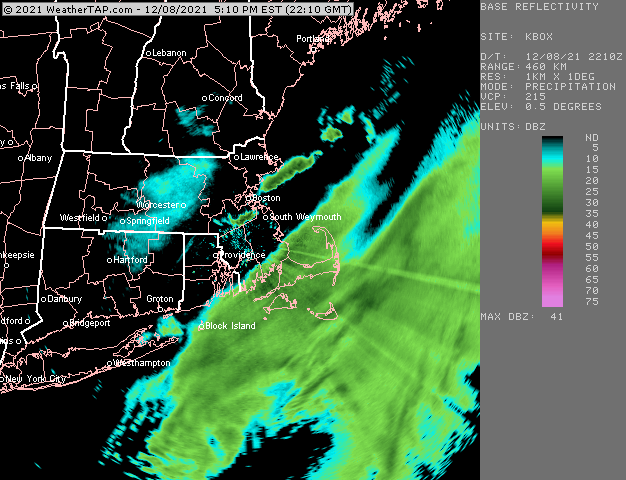
-
Wednesday 12/8 Possible Snow/Ice/Rain? Discussion
ORH_wxman replied to Torch Tiger's topic in New England
Column gets colder as we go further into the evening, so rain should change to snow in most places where it is still raining....outer Cape and Islands might be slower though. -
Wednesday 12/8 Possible Snow/Ice/Rain? Discussion
ORH_wxman replied to Torch Tiger's topic in New England
Lobster boats coming back with a foot of paste on the deck. -
Wednesday 12/8 Possible Snow/Ice/Rain? Discussion
ORH_wxman replied to Torch Tiger's topic in New England
ALB radar being down really sucks....hard to see upstream convergence zones, -
Wednesday 12/8 Possible Snow/Ice/Rain? Discussion
ORH_wxman replied to Torch Tiger's topic in New England
No that isn't what I'd forecast....I'd prob forecast 1-2" but emphasize the uncertainty associated with IVT setups. It's always possible you miss out on accumulations in these setups. -
Wednesday 12/8 Possible Snow/Ice/Rain? Discussion
ORH_wxman replied to Torch Tiger's topic in New England
ORH will be just far enough inland to avoid the regression. -
Wednesday 12/8 Possible Snow/Ice/Rain? Discussion
ORH_wxman replied to Torch Tiger's topic in New England
Taunton was overdue for some screwgies -
Wednesday 12/8 Possible Snow/Ice/Rain? Discussion
ORH_wxman replied to Torch Tiger's topic in New England
I don't think that is your meaningful snow if you get any....later this evening is what you'll want to look for. This current stuff is mostly for the shore...might be some flakes inland with it, but prob little if any measurable snow. If this starts to expand and blossom well NW though as we get into the 4-5pm hour, then that would definitely be a good sign. -
December 2021 Obs/Disco...Dreaming of a White-Weenie Xmas
ORH_wxman replied to 40/70 Benchmark's topic in New England
Look on the bright side, you might conserve a half inch pack. -
Wednesday 12/8 Possible Snow/Ice/Rain? Discussion
ORH_wxman replied to Torch Tiger's topic in New England
Yep. BOS literally went a decade without a 12”+ storm from Feb 1983 to March 1993. LOL. SE MA and up into BOS probably have increased their 30 year snowfall by a solid 10-15% in the past 2-3 decades. That is a monster number for a 30 year average to increase for places that avg between 35-50”. Regression has a lot more work to do. -
December 2021 Obs/Disco...Dreaming of a White-Weenie Xmas
ORH_wxman replied to 40/70 Benchmark's topic in New England
Thursday could be a pretty damned warm, though I worry about the CAD eroding fast enough to maximize it.....most of New England will be backdoored on Wednesday though. -
Wednesday 12/8 Possible Snow/Ice/Rain? Discussion
ORH_wxman replied to Torch Tiger's topic in New England
How did he not get 12" in March 2019? too far south? -
December 2021 Obs/Disco...Dreaming of a White-Weenie Xmas
ORH_wxman replied to 40/70 Benchmark's topic in New England
If we can warm sector on Thursday, we could challenge all time monthly high temp records. We're looking at like +10 to +14C 850 temps. Similar to 12/29/84 and 12/6-7/98. -
Wednesday 12/8 Possible Snow/Ice/Rain? Discussion
ORH_wxman replied to Torch Tiger's topic in New England
Radar right now doesn't mean anything....if nothing is blossoming by 7-8pm tonight, then it's prob a bust. IF good snows develop prior to 6pm, then that would be a very good sign. -
December 2021 Obs/Disco...Dreaming of a White-Weenie Xmas
ORH_wxman replied to 40/70 Benchmark's topic in New England
Next Wed/Thu torch could be "ruined" by a sneaky high pressure to the north. Been showing up on a lot of guidance. -
Wednesday 12/8 Possible Snow/Ice/Rain? Discussion
ORH_wxman replied to Torch Tiger's topic in New England
Too early to know how IVT will play out...the precip will basically blossom almost overhead later today and tonight. -
December 2021 Obs/Disco...Dreaming of a White-Weenie Xmas
ORH_wxman replied to 40/70 Benchmark's topic in New England
Yeah this is pretty much it....it's still pina coladas, parrots, and banana hammocks next week, but the guidance is starting to get more aggressive for a favorable Pacific beyond that. We still are contending with the big -PNA, but it's not digging the trough as much as before. It's more like PAC NW instead of max anomalies down in CA and even into Baja. -
December 2021 Obs/Disco...Dreaming of a White-Weenie Xmas
ORH_wxman replied to 40/70 Benchmark's topic in New England
Going into Phase 8 would definitely help as we go into late Dec/January....IIRC we actually had a potent phase 8 wave in January 2011 after the huge NAO blocking broke down post-Jan 12th storm. I believe the same thing happened in January 2009 after the NAO blocking broke down early in the month. -
Wednesday 12/8 Possible Snow/Ice/Rain? Discussion
ORH_wxman replied to Torch Tiger's topic in New England
Yeah probably, but someone may get lucky with 3 or 4" if there's enough LL convergence. -
Wednesday 12/8 Possible Snow/Ice/Rain? Discussion
ORH_wxman replied to Torch Tiger's topic in New England
RGEM likes C/W MA and CT. -
Wednesday 12/8 Possible Snow/Ice/Rain? Discussion
ORH_wxman replied to Torch Tiger's topic in New England
NAM tries to bring some 600mb goodies into the Cape late today...might be something to watch there. I'm a bit skeptical, but can't rule it out. 06z Euro wasn't that far off...just a little offshore with them. IF they got some of that outer ML fronto stuff, they could flip to wet snow for several hours.


