ORH_wxman
-
Posts
93,095 -
Joined
-
Last visited
Content Type
Profiles
Blogs
Forums
American Weather
Media Demo
Store
Gallery
Everything posted by ORH_wxman
-
That blizzard comment was just for him.
-
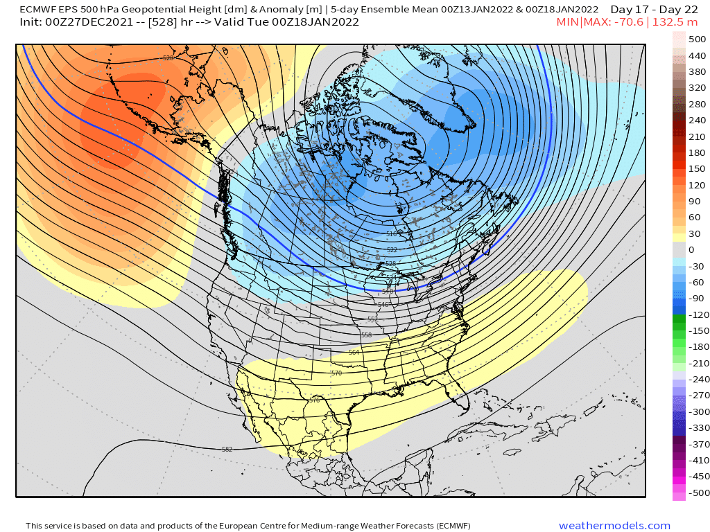
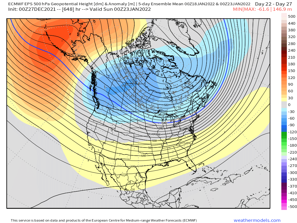
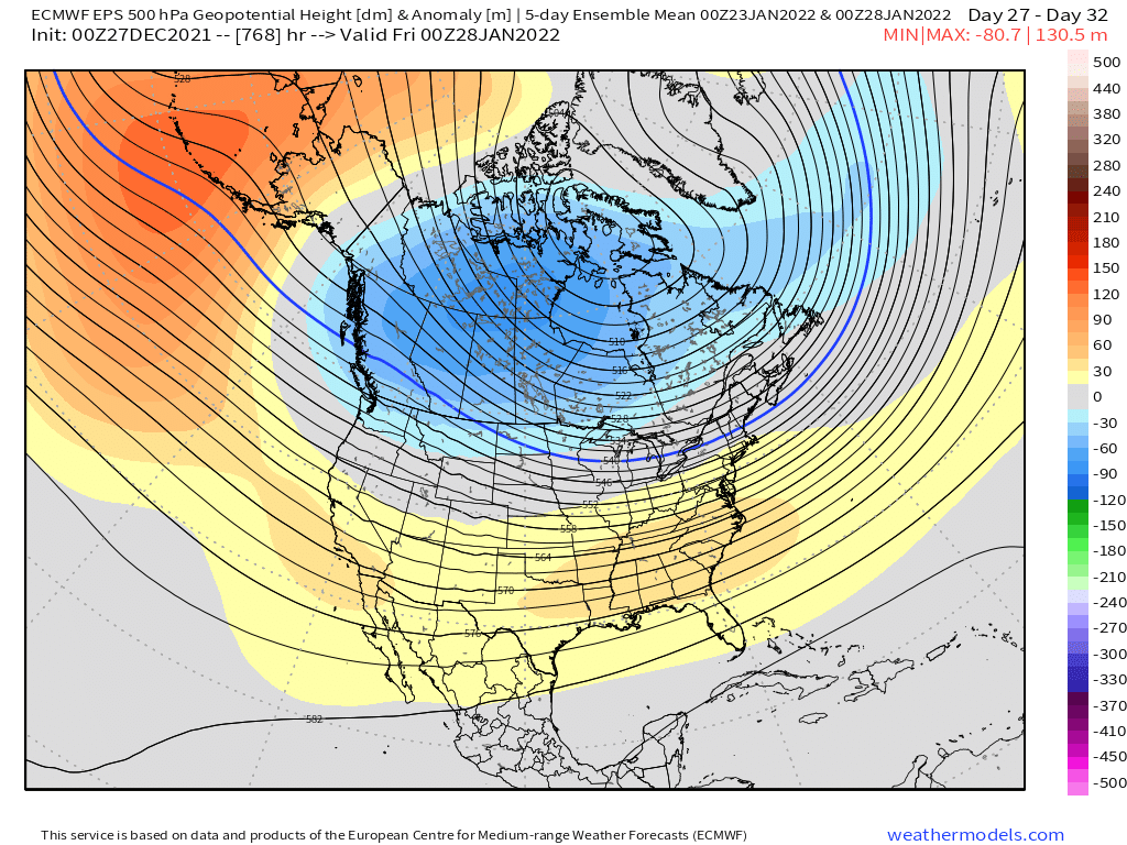
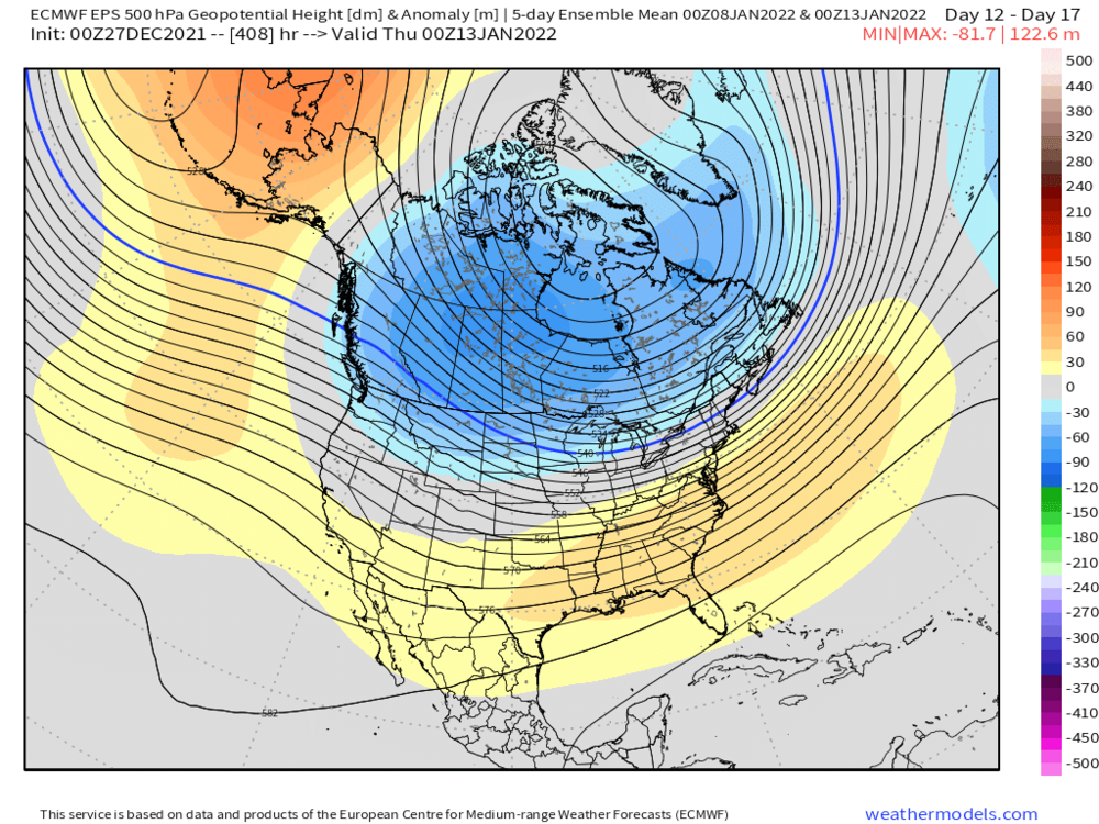
Yep. Maybe we can get a nice period like Jan 94 or late Dec 08 through mid Jan 09. Can get some Miller Bs in that pattern too but a little harder…nobody should have visions of monster blizzards dancing in their head.
-
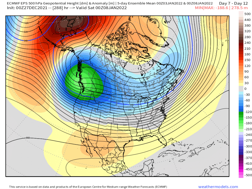
They’ve done pretty well in the arctic but they definitely underestimated the PNA trough out west.
-
I think it looks quite good. Obviously we need it to verify…but I’m totally fine with that pattern. Big ridging in the Bering strait with weak SE ridging is actually pretty classic for active/snowy pattern in New England. It is cold too.
-
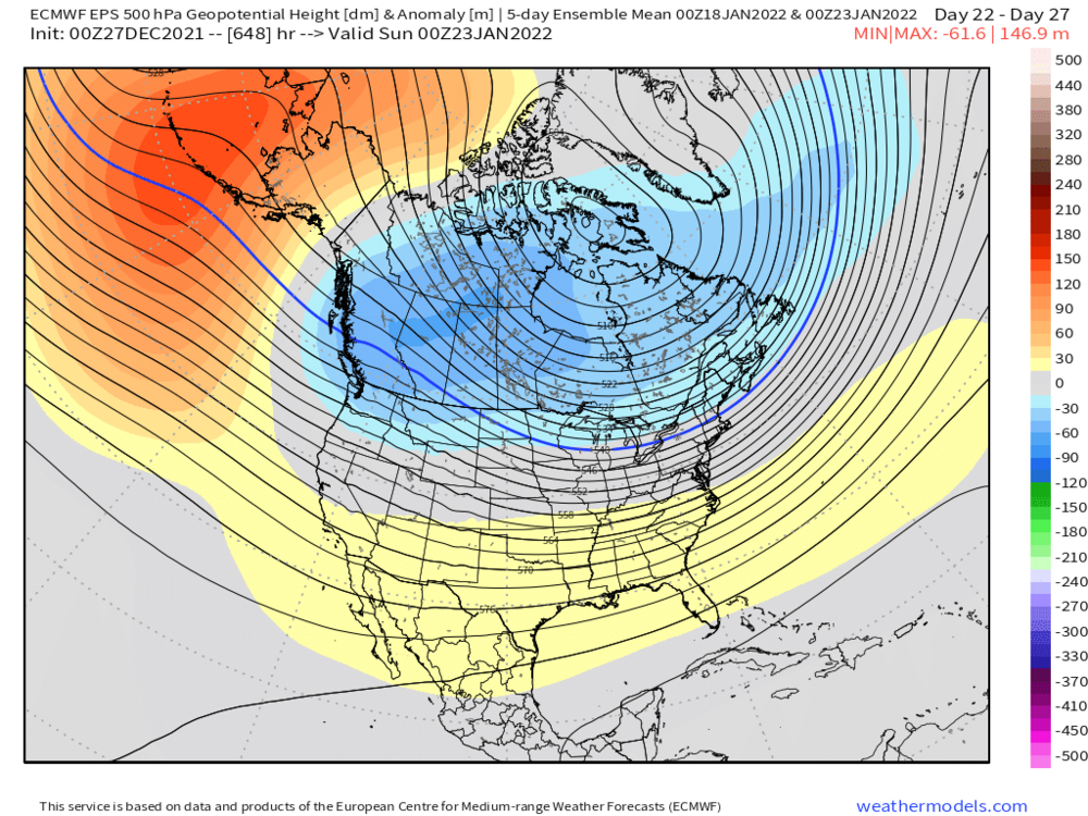
Here’s the progression…this is still pretty classic La Niña but at least we’re not digging the trough into palm trees down in Cabo San Lucas


-
Weeklies are pretty chilly for January. Hopefully we can start playing catch-up in the snow department.
-
December 2021 Obs/Disco...Dreaming of a White-Weenie Xmas
ORH_wxman replied to 40/70 Benchmark's topic in New England
ORH had about an inch of snow/ice OTG until yesterday. -
December 2021 Obs/Disco...Dreaming of a White-Weenie Xmas
ORH_wxman replied to 40/70 Benchmark's topic in New England
It’s prob fairly close but I’ll bet “pit2” averages a bit more. But they can get skunked sometimes being right on the water in the wrong type of pattern…that’s why it’s close to begin with and once you go a few miles inland in Maine it increases rapidly….in a latitude gradient pattern they will do much better regardless. -
December 2021 Obs/Disco...Dreaming of a White-Weenie Xmas
ORH_wxman replied to 40/70 Benchmark's topic in New England
Yeah it looked like maybe an inch…2 if lucky. -
December 2021 Obs/Disco...Dreaming of a White-Weenie Xmas
ORH_wxman replied to 40/70 Benchmark's topic in New England
Yeah this initial stuff shreds as it heads into tri-state region but overnight another pulse looks like it will survive a bit better. Still nothing big but a couple inches wouldn’t be shocking. -
December 2021 Obs/Disco...Dreaming of a White-Weenie Xmas
ORH_wxman replied to 40/70 Benchmark's topic in New England
Yeah GFS is on board for overnight as well. -
December 2021 Obs/Disco...Dreaming of a White-Weenie Xmas
ORH_wxman replied to 40/70 Benchmark's topic in New England
RGEM also has an inch or two overnight. -
Yeah his area for sure, but isn’t SNE which I referencing in the original post. The Dec 17th storm down here was not like that. We all got roughly in the 12-18” range. A big storm for sure but not like 40-50% of the seasonal total for most.
-
December 2021 Obs/Disco...Dreaming of a White-Weenie Xmas
ORH_wxman replied to 40/70 Benchmark's topic in New England
The NAM runs this morning are giving a bit more snow tonight. 2-3” for a good chunk of SNE on the 12km….3km is more like 1-2”. -
You can say that about a lot of winters though. Taking away the largest snowfall in a region where part of the snowfall climo is large synoptic storms will obviously make it look worse. How does ‘68-69 look when we take away the late Feb ‘69 storm or 2012-2013 look when we take away the Feb blizzard?
-
Well this is the pattern to get that started. Best snows in the type of pattern forecasted over the next 10-15 days will be those with some latitude.
-
Your small area in NE MA has been a bit of a screwgie the past 3 winters but not indicative of the region as a whole. A good chunk of SNE did fine last year.
-
12/17/08 was a weak overrunning event that dropped an inch or two of snow and then a small glaze. It wasn’t a significant event. A couple days later we got a big snow event on 12/19/08.
-
A solid dose of crappy snow winters is needed IMHO. The 2000s/2010s turned us into entitled whiners.
-
We need another 495 paste bomb like last year to set some of the weenies over the cliff. Plenty of teetering right now.
-
Those are solid snow banks in your pics. The advantage of having lots of mixed crap in the snow is that you really solidify the pack and it also makes the snow banks look huge. I’ve had snow/sleet events of 4 inches that have bigger snow banks and piles than a 10-12 inch fluff bomb. Now that you have the glacier, just need the powder events on top.
-
It’s a little bit frustrating because while the pattern has kind of been crappy, it’s been nothing like other years with similar results. This type of snowless start to the season happens roughly once per decade in ORH. Last instances going into New Years this low were 2015, 2006, and 1999. Those years were just CONUS-wide chinook torches that never had anyone expecting snow. But this year has at least had some semblance of a few chances even if facing some headwinds. But still mostly skunked.
-
ORH sitting below 5” for the season on 12/26 isn’t within the 1 SD envelope either. Cruddy pattern and a little bit of crap luck on top of it. Could’ve scored something a little bigger (even if advisory) in either early December or more recently after 12/17 but it hasn’t happened.
-
Garbage decade. I think only the 1930s was worse. Median was 56.3 and mean is about 58”. Only 2 above average. Even the 1980s had 4 above average winters (3 if we count 87-88 as average since it was barely above avg).
-
The only generation that really has credence in saying that are those who had most of their childhood from the late 1950s through early 1970s. That was a pretty awesome stretch. The modern version of that will be those who grew up mostly between 2000-2015. The difference is that there were a couple awful ratters mixed in but they also had some really high end winters that even the 1960s had trouble matching like 2014-2015…and the ridiculous storms too. Really high end KU type events.