

ORH_wxman
-
Posts
93,095 -
Joined
-
Last visited
Content Type
Profiles
Blogs
Forums
American Weather
Media Demo
Store
Gallery
Everything posted by ORH_wxman
-
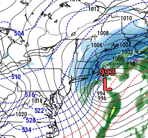
This is why I have remained fairly bullish on this threat from a few days ago....the vort tracks almost ideal for SNE snow events. I still am not convinced the circulation doesn't end up more consolidated sooner than shown either.
-
Yeah congeal that crap a little sooner and this would be a 12"+ nuke over a swath of SNE.
-
This run is prolonging the snowfall too. Really trying to make that western low more dominant by 15z tomorrow.
-
18z NAM is going to be good for many.
-
18z NAM looks a little more amped through 15 hours than 12z.
-
Yes agreed....it's not really the true spread showing there on the ensembles...it just some ensembles have the eastern low slightly stronger than the western one so the map "chooses" that low as the main one.
-
The dual low structure eventually gets gobbled up into one main low on all guidance....but where that happens is key...if it happens sooner, it really prolongs the heavier snowfall in SNE and that would mean we have to up the amounts....if it happens much later, then it keeps snow amounts more adivsory/low end warning (in eastern areas) most likely.
-
I'm still trying to figure out how fake or real the convective low structure is....and it's not binary either. It can be "mostly real" or "mostly fake" but that probably has some meaningful sensible wx impacts.
-
You can see how consolidated the RAP is trying to get the low by tomorrow morning...this is 15z (10am) tomorrow
-
RAP has been getting better each run it seems. Still out of its wheelhouse, but it'll be interesting to see if this carries over the 18z model suite for the big boys.
-
Moneypitmike? Lol
-
-25C 850 temps down to the pike...that is prob single digit highs for interior and not much above 10F even around BOS.
-
It had never happened 3 consecutive before that....or since. Truly an anomaly....a depressing one for a young snow weenie, lol. Anyways....prob not seeing 10" with this one, but can't entirely rule it out. I'd prob go 5-8" for ORH in this one.
-
Waking up at 5am and seeing Mark Rosenthal or Todd Gross on "upping amounts to 6-10" was like winning the lottery.
-
And to think ORH (not BOS....but ORH) went 4 consecutive seasons without a 10" event back then is mind-numbing.
-
These were blockbusters in the late 1980s/early 1990s before Dec 1992. You got excited for 3-6 but 5-10 was literally "having trouble falling asleep" type excitement like on Christmas Eve. Just the chance of getting 10" was exhilarating.
-
It good that it didn't shift much at all from 06z....we had been previously seeing a distinct shift eastward, but this time it more or less held serve except maybe on the margins (and those on the margins will notice)
-
Nice -32C 850s over Chicago at the end, lol. Trying to make a run at 1994.
-
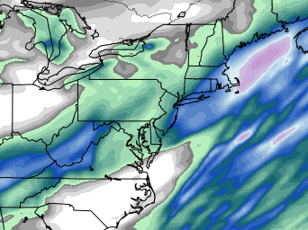
Yeah it could be a little light snow up in NH/VT and Maine....it isn't much QPF though.
-
Improved quite a bit actually...but it was also perhaps one of the worst runs at 00z, so no surprise it is coming back in line with other guidance.
-
Good run for the QPF queens...
-
I usually take the 600-800 avg...often the best banding will end up on the NW edge of that. Not all the time, but frequently. modeling best fronto isn't the easiest thing for guidance...it's pretty easy to be off like 25 miles on a short term forecast...but obviously that can make a huge difference in amounts if someone was supposed to be under that but it ended up 25 miles east.
-
Yeah thats been trending colder....and the sfc cold may be underdone too if there is a fresh snow pack for it to rest on.
-
MPM could complain his way to a jackpot too there in Westborough.
-
I actually like my spot for a potential jack...far enough east for good QPF but far enough west and a little elevation for decent ratios. We'll see though....interior SE MA near the usual suspects like Foxborough are primed too for some heavy bands and their few hundred feet will help ratios some.


