ORH_wxman
-
Posts
93,092 -
Joined
-
Last visited
Content Type
Profiles
Blogs
Forums
American Weather
Media Demo
Store
Gallery
Everything posted by ORH_wxman
-
Trough is def hanging back west of the 12z run through 24 hours. Doesn't mean it will end up better at the surface, but that's a general trend you want if there's any hope of getting this another 50-75 miles west....you want the trough to not be as progressive.
-
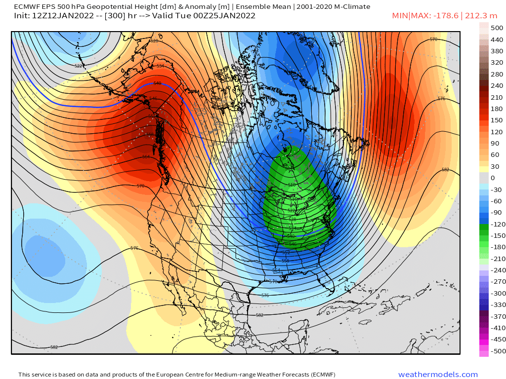
Yeah well the reasons are obvious we don't want people to compare anything to 2015. They will just think it means we're gonna get tons of snow again like that year. But the pattern is remarkably similar going into late January this year. Hopefully we can at least get a pretty snowy period....we don;t expect 90-100 inches in 3 weeks, but even a third of that would be pretty awesome.
-
Whats funny is the huge cutter in Jan 2015 that caused many to throw in the towel happened on 1/18...a day after this storm will happen...and an almost identical pattern was being shown for the final 2 weeks of that month that the EPS are now showing.
-
Scooter, you are required to click the link above
-
https://getyarn.io/yarn-clip/3e7b64fd-46bb-4cbb-bcff-b1e62839733f

-
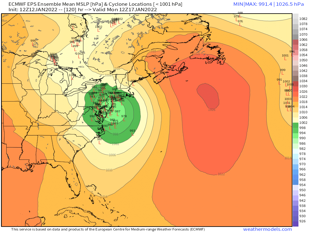
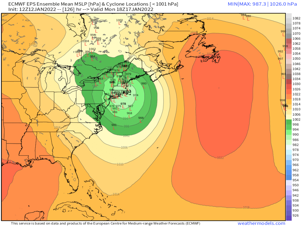
Monitoring a potential important TV to East Coastal storm: Jan 17
ORH_wxman replied to Typhoon Tip's topic in New England
-
Monitoring a potential important TV to East Coastal storm: Jan 17
ORH_wxman replied to Typhoon Tip's topic in New England
I mean, it wouldn't take much more to do that...it goes from ABE to ALB. The initial confluence did seem to make the front end a little colder this run though...so if that is a trend that we can keep up, then we might be able to get a triple point low further east in later runs. -
Monitoring a potential important TV to East Coastal storm: Jan 17
ORH_wxman replied to Typhoon Tip's topic in New England
The 1980s would be 1-3" washed away completely. I'm hoping this can morph into a 8-10" front ender that gets compacted down to like 5-6" and then FROPA. But these westward trends may not be done yet. -
Monitoring a potential important TV to East Coastal storm: Jan 17
ORH_wxman replied to Typhoon Tip's topic in New England
That would probably be a hellacious thump for several hours though. -
Monitoring a potential important TV to East Coastal storm: Jan 17
ORH_wxman replied to Typhoon Tip's topic in New England
If this system was progressive at all, we'd prob be in pretty good shape, but it just stops gaining longitude. -
Monitoring a potential important TV to East Coastal storm: Jan 17
ORH_wxman replied to Typhoon Tip's topic in New England
This is gonna cut into NY State.... -
Monitoring a potential important TV to East Coastal storm: Jan 17
ORH_wxman replied to Typhoon Tip's topic in New England
Shotwave #3 looks to be digging more this run too....which will send our southern shortwave straight north...so I bet this run ends up west of 00z. -
Monitoring a potential important TV to East Coastal storm: Jan 17
ORH_wxman replied to Typhoon Tip's topic in New England
Yeah that shortwave down south seems to just be able to slow down if it needs to and wait for the confluence to lift out. This will probably still be a pretty far west run....but I'm hoping it's a little east of 00z....any eastward ticks will help. -
Monitoring a potential important TV to East Coastal storm: Jan 17
ORH_wxman replied to Typhoon Tip's topic in New England
Friday's system is def hanging back on this euro run....we'll see how much that affects the Monday storm. -
Doubt it comes much more west...there isn't much room in the flow to shift that west.
-
Euro might even get an inch or two back here.
-
Monitoring a potential important TV to East Coastal storm: Jan 17
ORH_wxman replied to Typhoon Tip's topic in New England
The 12z GEFS i have show a lot of interior lows.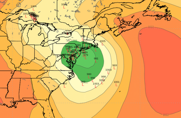
-
I think the '87 storm was a huge bust too...winter storm warnings out for most of BOS area and the thing decides to just squeeze east but destroy the Cape in an epic manner. The graidnet must have been epic....CHH 28", HYA 16", East Wareham 10"....then Kingston coop had like 3"....lol
-
Maybe we can get a repeat of 2/9-10/87? CHH gets 28 inches while you get 3" and I get an inch?
-
Monitoring a potential important TV to East Coastal storm: Jan 17
ORH_wxman replied to Typhoon Tip's topic in New England
We might all get warm sectored....that's why we gotta hope this goes more over BOS or SE MA/Cape. -
Monitoring a potential important TV to East Coastal storm: Jan 17
ORH_wxman replied to Typhoon Tip's topic in New England
Still a pretty big frotn ender for the interior on Ukie. That would be my hope right now...that this ends up more like a BOS track and we get some real goods on the front end. -
Monitoring a potential important TV to East Coastal storm: Jan 17
ORH_wxman replied to Typhoon Tip's topic in New England
I'll want to see EPS shift east a some today...there was a good cluster of members as far west as the GFS on the 06z EPS run. -
Monitoring a potential important TV to East Coastal storm: Jan 17
ORH_wxman replied to Typhoon Tip's topic in New England
Yeah it was pretty clear early on that the Friday system was hanging back and slower to exit. -
Monitoring a potential important TV to East Coastal storm: Jan 17
ORH_wxman replied to Typhoon Tip's topic in New England
Yeah those changes early on were enough to hold in the cold a bit better. Stil want to see this not track west of us...but well see if other guidance follow ssuit. -
Monitoring a potential important TV to East Coastal storm: Jan 17
ORH_wxman replied to Typhoon Tip's topic in New England
Yeah this is prob gonna be like 00z....still pretty amped but not quite as much as 06z.