ORH_wxman
-
Posts
93,092 -
Joined
-
Last visited
Content Type
Profiles
Blogs
Forums
American Weather
Media Demo
Store
Gallery
Everything posted by ORH_wxman
-
Monitoring a potential important TV to East Coastal storm: Jan 17
ORH_wxman replied to Typhoon Tip's topic in New England
It still looks a lot worse than the GFS. It needs another solid bump east. -
Monitoring a potential important TV to East Coastal storm: Jan 17
ORH_wxman replied to Typhoon Tip's topic in New England
If you saw the 12z snow maps, the 18z ones are almost exactly the same except they go to 90 hours so have to take that into account. Esp northern peeps. -
Monitoring a potential important TV to East Coastal storm: Jan 17
ORH_wxman replied to Typhoon Tip's topic in New England
Yeah we never got the whole system to come back west on that one. However, The PVA ended up really enhancing the banding a bit more than earlier guidance suggested…but that became apparent on the later runs when QPF boosted into the 0.50 range from the lower 0.2-0.3 amounts on earlier runs. -
Monitoring a potential important TV to East Coastal storm: Jan 17
ORH_wxman replied to Typhoon Tip's topic in New England
Trying to redevelop the ML center too. But I want to see some more support. No other model looks like that. -
Weeklies go back to -PNA and SE Ridge in February....they are frigid for late January though.
-
Monitoring a potential important TV to East Coastal storm: Jan 17
ORH_wxman replied to Typhoon Tip's topic in New England
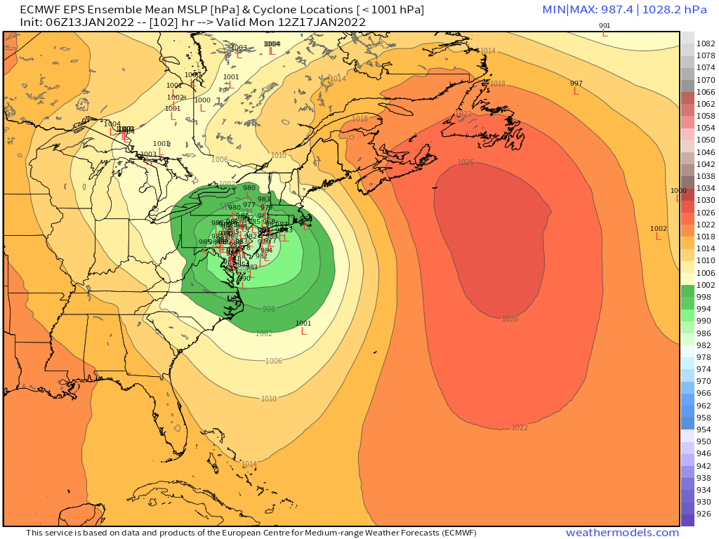
It is definitely a Miller A as currently modeled if we're going by the original definitions from Miller et al 1946. If this started tracking into the TN Valley or OH Valley with a clear secondary redevelopment, then we could revisit, but yeah, not really worth the energy debating it at the moment. -
Monitoring a potential important TV to East Coastal storm: Jan 17
ORH_wxman replied to Typhoon Tip's topic in New England
12/26-27/12 was a pretty good storm for interior SNE....I think I had 7" with a bunch of IP/ZR in that one. A bit further NW had over a foot. -
Monitoring a potential important TV to East Coastal storm: Jan 17
ORH_wxman replied to Typhoon Tip's topic in New England
EPS spread actually increased from 06z which is weird when you get closer.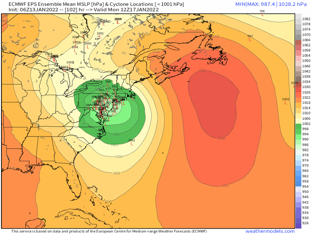
-
Crazy cold shallow airmass there. Euro even gets BOS down to 0F.
-
Monitoring a potential important TV to East Coastal storm: Jan 17
ORH_wxman replied to Typhoon Tip's topic in New England
Yep....how many times over the years (even in biggies like Feb 2013) did the models over-phase the streams? We've seen plenty of times where the southern ends up a little faster and the phase happens later than originally modeled. Doesn't mean it will happen this time, but it's a more realistic scenario than hoping for the northern stream to come in weaker....in my experience, the northern stream will probably come in stronger when sampled. -
Monitoring a potential important TV to East Coastal storm: Jan 17
ORH_wxman replied to Typhoon Tip's topic in New England
It's a pretty good thump in SNE too away from the water. -
Monitoring a potential important TV to East Coastal storm: Jan 17
ORH_wxman replied to Typhoon Tip's topic in New England
I think one realistic hope on this system is that the southern stream ends up more progressive as we get closer....that's actually a real thing that happens on model guidance a decent amount. I don't have much hope for the northern stream to help us coming in weaker, but a more progressive southern stream seems plausible. -
Monitoring a potential important TV to East Coastal storm: Jan 17
ORH_wxman replied to Typhoon Tip's topic in New England
I'm comparing to 06z....00z was really amped, and I agree it will be east of 00z. -
Monitoring a potential important TV to East Coastal storm: Jan 17
ORH_wxman replied to Typhoon Tip's topic in New England
Yeah the northern shortwave is the last one to come on shore, so hopefully the northeast height trend is real and the northern stream shortwave trend is spurious....but I'm not holding my breath. -
Monitoring a potential important TV to East Coastal storm: Jan 17
ORH_wxman replied to Typhoon Tip's topic in New England
Northern stream shortwave is way stronger this run...so that is going to wipe out any advantage I think in the northeast. Strong northern stream just send this due north from what we know in past runs. Too much whack-a-mole with this system. -
Monitoring a potential important TV to East Coastal storm: Jan 17
ORH_wxman replied to Typhoon Tip's topic in New England
12z Euro does look like it's coming in a bit more suppressed with heights in the northeast through 54h vs 06z. The southern shortwave isn't much different...so I'm guessing this one should come east a little from 06z. -
Monitoring a potential important TV to East Coastal storm: Jan 17
ORH_wxman replied to Typhoon Tip's topic in New England
I don't think there's much hope for a major snowfall, but there's still the difference between like 8-12" and 2-5" on the table which is a pretty large impact from a sensible wx standpoint. -
Monitoring a potential important TV to East Coastal storm: Jan 17
ORH_wxman replied to Typhoon Tip's topic in New England
Only reason I'd still hold out for a bigger solution is that we are still 96h from go time...if we were 72 then I'd be resigned to an Albany or CT River track. But outside of the GFS, there isn't much support for something more favorable. Pending the Euro obviously, but I do not expect it to improve much, if at all, based on other 12z globals. IF Euro comes in flatter and ensembles also show that trend, then I think there is renewed life in this. -
Monitoring a potential important TV to East Coastal storm: Jan 17
ORH_wxman replied to Typhoon Tip's topic in New England
That's a solid tick west from 00z which tracked from NYC up into S VT. -
Monitoring a potential important TV to East Coastal storm: Jan 17
ORH_wxman replied to Typhoon Tip's topic in New England
Still tracks it well inland...roughly IPT/ALB/BTV -
Monitoring a potential important TV to East Coastal storm: Jan 17
ORH_wxman replied to Typhoon Tip's topic in New England
GGEM is quite a suppressed through 48 hours compared to 00z....but that doesn't necessarily mean a ton considering the 00z GGEM tracked this storm through ROC. -
Monitoring a potential important TV to East Coastal storm: Jan 17
ORH_wxman replied to Typhoon Tip's topic in New England
Maybe some drizzle at the end? That doesn't even look saturated above 900mb. -
Monitoring a potential important TV to East Coastal storm: Jan 17
ORH_wxman replied to Typhoon Tip's topic in New England
Yeah it kind of starts compressing those lows as they gain latitude....we want to see those compressed and elongating more E-W....if H5 starts elongating E-W, then it will try and produce a redeveloping ML center to the east. Even if the eastern ML center doesn't become dominant before reaching us, just having it develop will help a lot as it will slow down the WAA. -
Monitoring a potential important TV to East Coastal storm: Jan 17
ORH_wxman replied to Typhoon Tip's topic in New England
If we can have that southern stream bulge out to the east a bit, we can prob redevelop a mid-level center. You can almost see this happening on the GFS at 96 hours....look at that kink in the 700mb heights and how it's even seen a little bit at H5....if we can have that poking east just a bit even if the actual H5 center is further west, then that would help a lot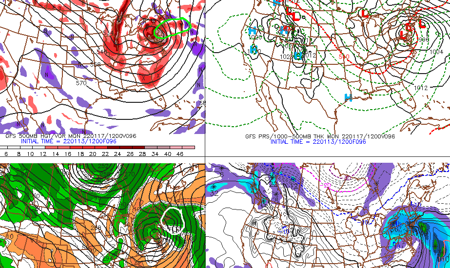
-
Monitoring a potential important TV to East Coastal storm: Jan 17
ORH_wxman replied to Typhoon Tip's topic in New England
That's essentially a wash with 06z GFS....there are some really minor differences, but not worth getting out an electron microscope to analyze a 90-96 hour solution. We had counter-acting trends on that run aloft...we had better confluence holding to out north and east, but the southern shortwave was a tad slower that run which allowed it to amplify and "Catch up" to the 06z run later on...I think some spots further south were a little colder this run too, but again, small differences.