ORH_wxman
-
Posts
93,095 -
Joined
-
Last visited
Content Type
Profiles
Blogs
Forums
American Weather
Media Demo
Store
Gallery
Everything posted by ORH_wxman
-
Lol, you stole my line....I was gonna reply that hopefully it means the ICON super computer burnt out and can't be replaced.
-
That would be even worse IMHO....it ends up historic for a huge area and you're one of the few screw zones that get 6". But hopefully that doesn't happen anyway....a NAM-esque solution would be pretty ridiuclous for most of the forum. The Cape peeps would get screwed a bit, but very few elsewhere.
-
NAM will probably have a run that goes even further west....but it's going to be hard to get much more given the trough position.
-
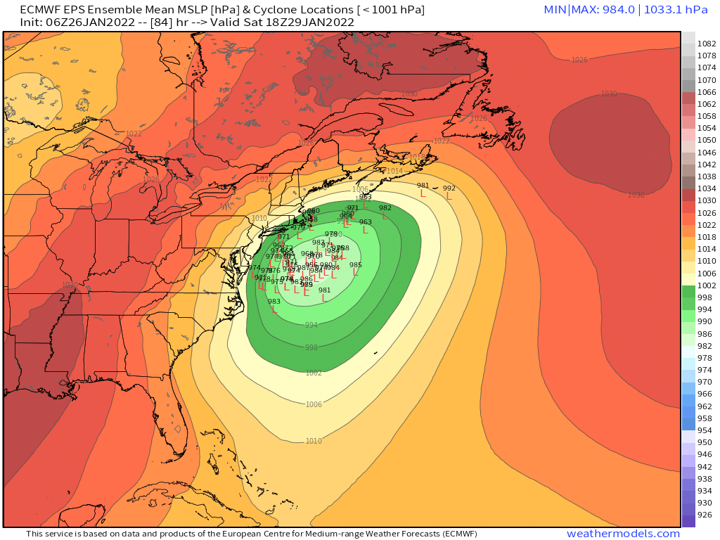
That is an amazing run...it is still absolutely hammering over NE at 84h too...that stall spot is pretty ideal.
-
If it closes off south of us and captures a bit....yes, I think we'd probably see that.
-
12z NAM will come west I think based on 42h...more southern stream and the northern stream is coming in a bit steeper.
-
Unless this comes way west, it's going be a powdery snow there
-
I would agree that I want to see some more guidance look closer to the Euro suite today...otherwise I think it will correct east some.
-
Jan '15 was pretty fluffy in ORH IIRC...it was windy, but not as windy as some other high end storms. It would occasionally rip 40+ but not the same frequency as Feb 2013 or January 2005.
-
Yeah Ray, 06z only goes to 90h. That is not close to being done up here.
-
06z euro would being the prolonged stall scenario back on the table. What a weenie solution.
-
Yeah that wouldn’t have too many screw zones once all was said and done.
-
Yeah I’m betting against the big capture scenario at the moment but we’ll see. My guess is it tries to sort of capture but it keeps ticking along. I was hoping for an 8-12 hour stall job in the middle of the storm but guidance is starting to move away from that idea.
-
Yeah not sure how he can say the euro didn’t move.
-
Decent chance you get it. I’d expect a compromise between euro and GFS.
-
Just catching up on euro and 06z guidance. Definite overall tick east…though it was good to see 06z GFS tick west. Hopefully that means we’re narrowing the goalposts a bit more. Some of the banding sigs are incredible with this system. There are going to be 3-4” per hour bands in this if it looks like that at go-time.
-
It nailed the block over Svalbard though. 2nd best model
-
Wow just saw the GGEM. Nice solution for a huge chunk of the board. Would be fun to get one that doesn’t have too many screw zones. Feels like everyone could use that this winter.
-
He probably doesn’t realize that ACK averages like 27” per year.
-
Yeah that’s interesting even though H5 looked slightly less zonked.
-
Making references to political commentators is still politics and it has zero place in the wx threads.
-
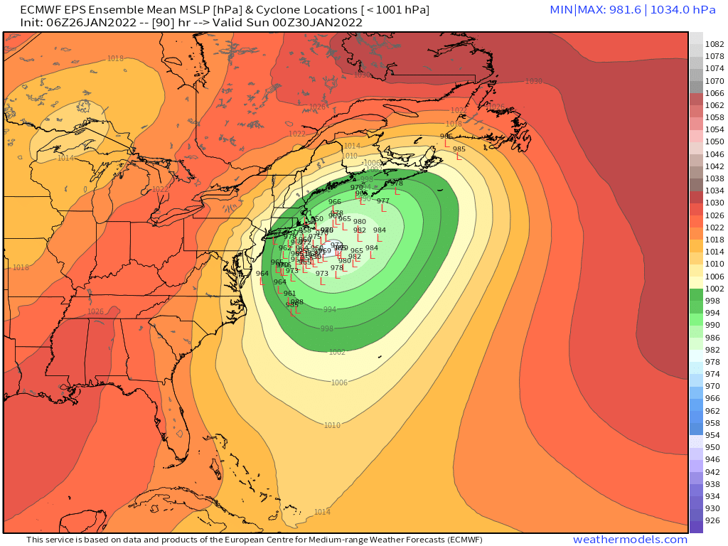
It’s still closing it off down south but it’s not capturing it quite as fast I don’t think. The capture would prob be a little bit further northeast of the 12z run but not too far off.
-
You weren’t piled on for calling him terrible met. He’s called a terrible met like 10x per day on here.