ORH_wxman
-
Posts
93,095 -
Joined
-
Last visited
Content Type
Profiles
Blogs
Forums
American Weather
Media Demo
Store
Gallery
Everything posted by ORH_wxman
-
That’s a 1994 sounding. Pretty hard to get that.
-
I mean, that was an all-timer. Like 60F dews and severe wx.
-
Yes that definitely really helped amplify the narrative…even the mainstream media was talking about it. Also, we never really tracked threats outside of day 5 seriously back in the day…and given that there weren’t a plethora of clown maps from the euro back then, people just didn’t really focus or spend time on a random Euro snowstorm at 150 hours out unless it showed up 2-3 runs in a row. So if one run moved 300 miles at day 6, nobody really made a huge fuss about it. Nowadays, with 25 different clown maps floating around, we can be sure half of them get posted if the model is showing a big solution 6 or 7 days out and then they facilitated a bunch of discussion on it…and then when the inevitable rug-pull happens the next run or two, you get a few tantrums talking about how crappy the model is.
-
That is nothing like ‘96.
-
Eh, it was a D5-6 prog that changed. I’d be more impressed if it was inside of 100 hours. I remember even back in its heyday, the euro had the 12/19/08 storm as a 60F cutter trough Ottawa at 138 hours. Next run it was a snowstorm and more or less held serve for the next 5 days.
-
That is a really cold high pressing but at the same time I feel like these usually end up north of consensus 5 days out. But this one has been trending colder, so who knows.
-
OBS/DISCO - The Historic James Blizzard of 2022
ORH_wxman replied to TalcottWx's topic in New England
Holliston MA -
OBS/DISCO - The Historic James Blizzard of 2022
ORH_wxman replied to TalcottWx's topic in New England
Great morning. Outside with the boys and they were loving it…took some pics of areas they weren’t trampling…lol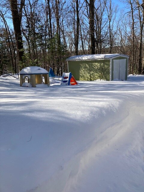
-
OBS/DISCO - The Historic James Blizzard of 2022
ORH_wxman replied to TalcottWx's topic in New England
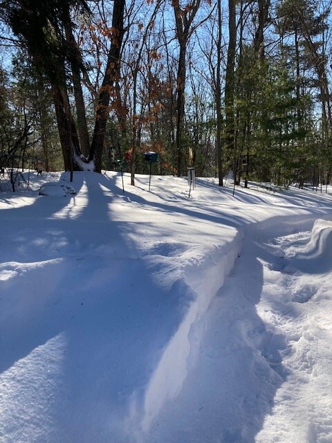
Trees do help a lot. I’ve noticed that where I live too. Snow seems much more evenly distributed with all the woods around me versus my old place which was not a ton of trees. The trees act as a wind break. -
OBS/DISCO - The Historic James Blizzard of 2022
ORH_wxman replied to TalcottWx's topic in New England
And TauntonBlizz posted a pic of him snow blowing that was pretty good evidence of 30”+. Snow on the level was comfortably over his 26” auger housing. -
OBS/DISCO - The Historic James Blizzard of 2022
ORH_wxman replied to TalcottWx's topic in New England
Yep. Bad run and over a 5 winter sample, pretty easy to happen. -
OBS/DISCO - The Historic James Blizzard of 2022
ORH_wxman replied to TalcottWx's topic in New England
That band was friggin awesome. It was like a lake effect streamer for a while. Grabbed an extra 3-4” of pure arctic fluff in about 2-3 hours. -
OBS/DISCO - The Historic James Blizzard of 2022
ORH_wxman replied to TalcottWx's topic in New England
The end is near now. You can tell we’re on the western side of it and it’s also weakening a little to boot. Vis up substantially in the last 5 min. -
OBS/DISCO - The Historic James Blizzard of 2022
ORH_wxman replied to TalcottWx's topic in New England
I echo this sentiment. Awesome storm for the UUU crowd and NeonPeon. Having young kids myself, I really appreciate the snowfalls more since I get to watch them go crazy in it. -
OBS/DISCO - The Historic James Blizzard of 2022
ORH_wxman replied to TalcottWx's topic in New England
Oh yeah. Right there near intersection of 290 and 495. I used to go there all the time to an old driving range near the Solomon Pond Mall. I think they closed it down years ago though. -
OBS/DISCO - The Historic James Blizzard of 2022
ORH_wxman replied to TalcottWx's topic in New England
What town is he again? I remember y out said he was just a bit east of ORH. -
OBS/DISCO - The Historic James Blizzard of 2022
ORH_wxman replied to TalcottWx's topic in New England
Yeah this stuff falling right now is 1-2” per hour stuff. I could believe 3” too with the how fluffy it seems to be. -
OBS/DISCO - The Historic James Blizzard of 2022
ORH_wxman replied to TalcottWx's topic in New England
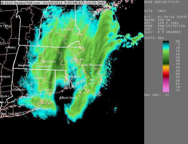
I wonder if the airport was just a smidge west of the meat of that. Because this is like a lake effect streamer in the heart of it. -
OBS/DISCO - The Historic James Blizzard of 2022
ORH_wxman replied to TalcottWx's topic in New England
These are like lake effect dendrites -
OBS/DISCO - The Historic James Blizzard of 2022
ORH_wxman replied to TalcottWx's topic in New England
It’s ripping under this. Def not 1 SM vis. -
OBS/DISCO - The Historic James Blizzard of 2022
ORH_wxman replied to TalcottWx's topic in New England
This is insane. Lol. But I love little surprises like this at the end of a big storm.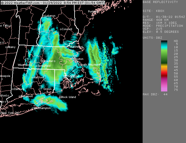
-
OBS/DISCO - The Historic James Blizzard of 2022
ORH_wxman replied to TalcottWx's topic in New England
Pure fluff being added right now.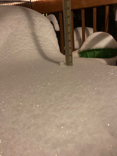
-
OBS/DISCO - The Historic James Blizzard of 2022
ORH_wxman replied to TalcottWx's topic in New England
Ramping up even more…lol. This is legit S+…if you didn’t look at the radar, you think you were in the height of the storm.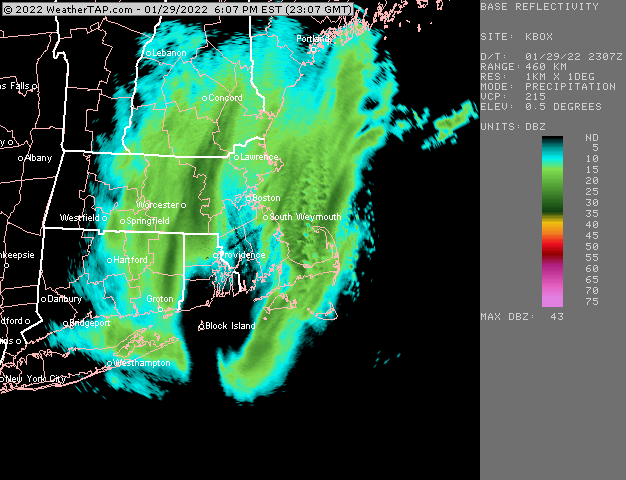
-
OBS/DISCO - The Historic James Blizzard of 2022
ORH_wxman replied to TalcottWx's topic in New England
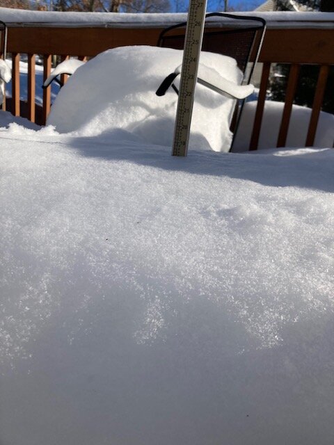
Yeah that’s good visual evidence of a 30 spot. That is legit. -
OBS/DISCO - The Historic James Blizzard of 2022
ORH_wxman replied to TalcottWx's topic in New England
Band is trying to reorganize a bit to the east. Wonder if Ray is getting that…I’d think with beam drift he has to be getting some of that