ORH_wxman
-
Posts
93,092 -
Joined
-
Last visited
Content Type
Profiles
Blogs
Forums
American Weather
Media Demo
Store
Gallery
Everything posted by ORH_wxman
-
March 2022 Obs/Disc: In Like a Lamb, Out Like a Butterfly
ORH_wxman replied to 40/70 Benchmark's topic in New England
The CAD is pretty deep....so you may get some sleet....the sfc winds are not strong and out of the E or NE. It will be interesting to see your obs. -
March 2022 Obs/Disc: In Like a Lamb, Out Like a Butterfly
ORH_wxman replied to 40/70 Benchmark's topic in New England
Wow thats a solid 3-4F step change. Makes sense now on that +8 monthly anomaly....tossed. -
March 2022 Obs/Disc: In Like a Lamb, Out Like a Butterfly
ORH_wxman replied to 40/70 Benchmark's topic in New England
Just give us one more good snow event....it's already a lock to be shitty and cold so we might as well cash in sometime next week or next weekend. -
March 2022 Obs/Disc: In Like a Lamb, Out Like a Butterfly
ORH_wxman replied to 40/70 Benchmark's topic in New England
Mass plant die-off next week with -20C 850 temps? -
March 2022 Obs/Disc: In Like a Lamb, Out Like a Butterfly
ORH_wxman replied to 40/70 Benchmark's topic in New England
No it's still there. Very blocky look for month-end. There's nothing imminent though, so not really worth commenting too much. There's an outside chance at something around D5-6 (there's some wave-spacing issues though), but I think the better chance is more like D8-10 assuming the block holds....it could just lift out too though like the OP GFS did today. -
March 2022 Obs/Disc: In Like a Lamb, Out Like a Butterfly
ORH_wxman replied to 40/70 Benchmark's topic in New England
It's tough love...he's given many opportunities to tone down his posts but refuses to take the hints. -
March 2022 Obs/Disc: In Like a Lamb, Out Like a Butterfly
ORH_wxman replied to 40/70 Benchmark's topic in New England
Deep insight that can only be found on Americanwx Forums. -
March 2022 Obs/Disc: In Like a Lamb, Out Like a Butterfly
ORH_wxman replied to 40/70 Benchmark's topic in New England
Yeah that's a very deep H5 anomaly just south of us. Also, EPS/GEFS have a pretty nice 'rhea signal for early April with a decaying west-based -NAO. -
March 2022 Obs/Disc: In Like a Lamb, Out Like a Butterfly
ORH_wxman replied to 40/70 Benchmark's topic in New England
IPA bottles everywhere all over the coach and floor. -
March 2022 Obs/Disc: In Like a Lamb, Out Like a Butterfly
ORH_wxman replied to 40/70 Benchmark's topic in New England
The reason you get a lot of resistance is for posts like these. Do you look at any data or just decide to post and hope it’s not spectacularly inaccurate? 1. There’s a decent chance that this March is actually colder than 2020 and 2021. Throw in 2016 too if you want yet another year that this one won’t beat post-2012. 2. All guidance is signaling a return to colder weather the final week of the month. -
March 2022 Obs/Disc: In Like a Lamb, Out Like a Butterfly
ORH_wxman replied to 40/70 Benchmark's topic in New England
How fast is it moving? Like 1mph? It was almost to the pike around noontime…and at 6pm, BAF-ORH-BOS all socked in with northerly wind flags. -
March 2022 Obs/Disc: In Like a Lamb, Out Like a Butterfly
ORH_wxman replied to 40/70 Benchmark's topic in New England
-
March 2022 Obs/Disc: In Like a Lamb, Out Like a Butterfly
ORH_wxman replied to 40/70 Benchmark's topic in New England
The clouds and precip are the big killers in spring. If it’s sunny, you can usually get away with a nice day unless it’s one of those strong CAA airmasses with lots of wind…then it sucks. -
March 2022 Obs/Disc: In Like a Lamb, Out Like a Butterfly
ORH_wxman replied to 40/70 Benchmark's topic in New England
It actually looks cold. Definitely could support a snow threat in the final week. But absent a snow threat it’s useless cold. -
March 2022 Obs/Disc: In Like a Lamb, Out Like a Butterfly
ORH_wxman replied to 40/70 Benchmark's topic in New England
Pattern looks like dogshit for the rest of the month. -
March 2022 Obs/Disc: In Like a Lamb, Out Like a Butterfly
ORH_wxman replied to 40/70 Benchmark's topic in New England
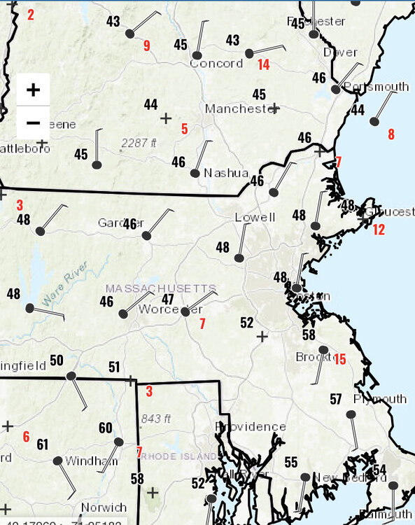
We did worse, but I still had around 4" of paste or so. ORH had around 7". -
March 2022 Obs/Disc: In Like a Lamb, Out Like a Butterfly
ORH_wxman replied to 40/70 Benchmark's topic in New England
Yeah that's fine.....and I'm just telling you that you actually have no idea if we'll get another event or not....not that you will be wrong in your prediction. For your area, you are prob like 50/50 not to see any more accumulating snowfall....up where I am, I'm probably favored to see it again. -
March 2022 Obs/Disc: In Like a Lamb, Out Like a Butterfly
ORH_wxman replied to 40/70 Benchmark's topic in New England
My worst winter in the past 25 years actually had accumulating snowfall on 4/26.....April 26, 2000. http://www.meteo.psu.edu/fxg1/NARR/2000/us0426.php -
March 2022 Obs/Disc: In Like a Lamb, Out Like a Butterfly
ORH_wxman replied to 40/70 Benchmark's topic in New England
The other winters were rats too....so yeah, this is unserious voodoo. -
March 2022 Obs/Disc: In Like a Lamb, Out Like a Butterfly
ORH_wxman replied to 40/70 Benchmark's topic in New England
Yeah, it's just weird he's using the logic "this winter has been bad, so that means any late season threat will fall apart" in a non-joking manner.....lol. I mean, we've had plenty of late season events in garbage winters (April 2020, April 2016 (2 events actually), late Mar and Apr 2007, late Mar 2002, Apr 1997, etc, etc) -
March 2022 Obs/Disc: In Like a Lamb, Out Like a Butterfly
ORH_wxman replied to 40/70 Benchmark's topic in New England
This sounds like voodoo gibberish. -
Definitely a masshole from Revere
-
She probably did more to help disadvantaged communities in a year with her outreach than most people do in their lifetimes. You are still coming across as an asshole in this thread.
-
March 2022 Obs/Disc: In Like a Lamb, Out Like a Butterfly
ORH_wxman replied to 40/70 Benchmark's topic in New England
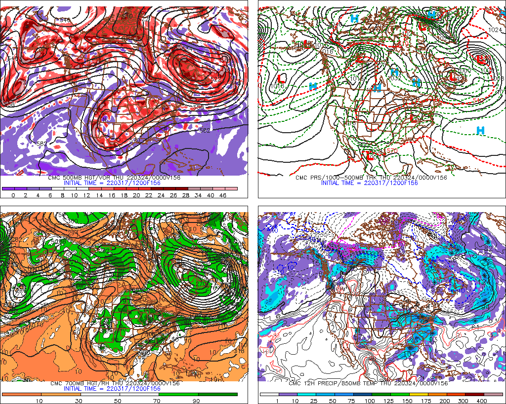
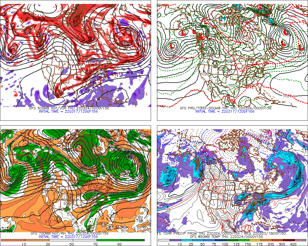
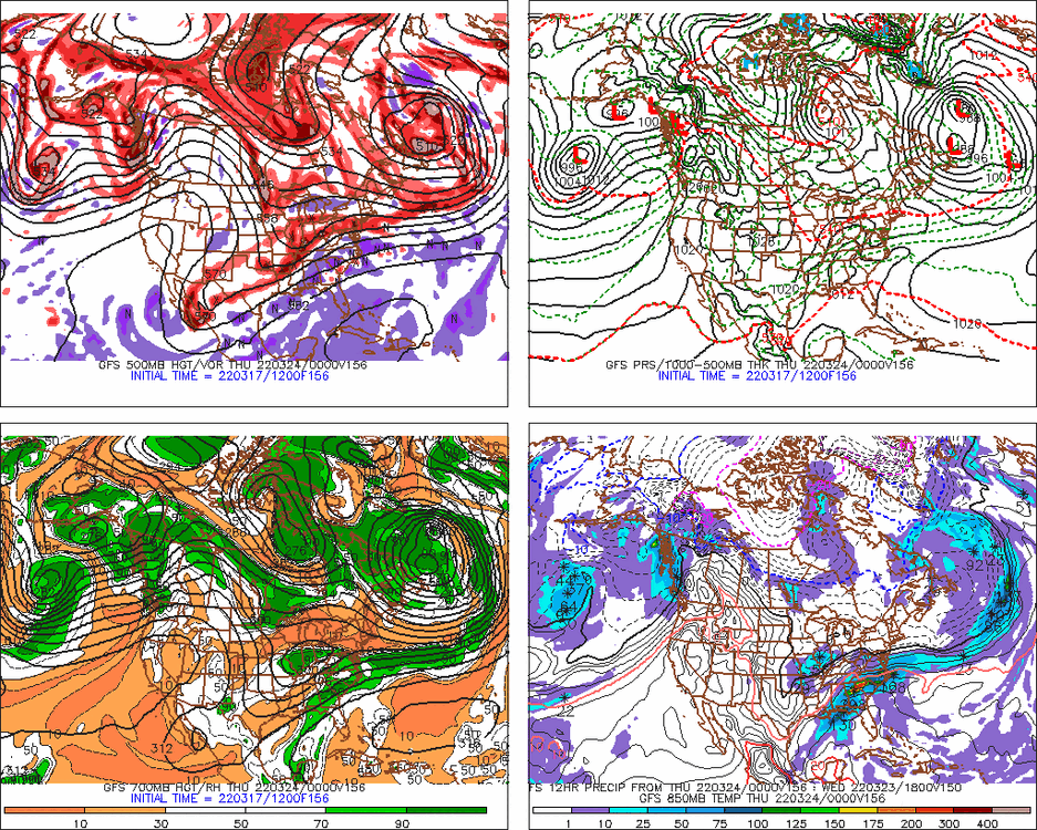
The larger scale features are interesting on the 12z runs....you have the massive PV lobe acting as the 50/50 low in Labrador/New Foundland and a trough ejecting out of the central CONUS. I'd like the trough to be a little more organized....seems kind of disjointed a little and positively tilted, but those are details we know can change easily at this lead time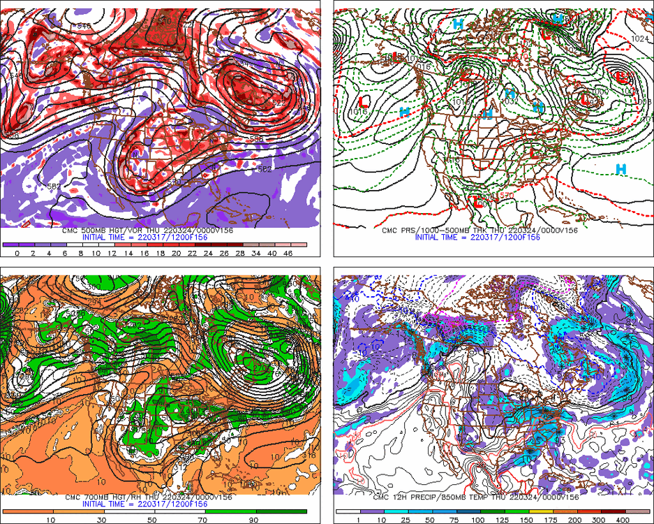
-
March 2022 Obs/Disc: In Like a Lamb, Out Like a Butterfly
ORH_wxman replied to 40/70 Benchmark's topic in New England
It was...mostly just January and a few fleeting periods in February. I'm still annoyed at December where the pattern wasn't that far from being really good. We just somehow managed to get a -20 sigma PNA when a merely solidly negative PNA would have been fine.