ORH_wxman
-
Posts
93,092 -
Joined
-
Last visited
Content Type
Profiles
Blogs
Forums
American Weather
Media Demo
Store
Gallery
Everything posted by ORH_wxman
-
First 10-12 days of the month were just a full-on blowtorch.....then we kind of got into that semi-colder pattern.....SE ridge was just a shade too robust and that was prob a direct result of the PNA being so deep out west. 1970 had a more favorable NAO to keep it cold too. Displaced like 500+ miles south of where 2021 was.
-
I didn't think December 2021 was that far off from being really good. The 2nd half of the month actually had a pattern similar to Dec 1970....but just a shade more -PNA and confluence up by us which ended up being all the difference. You could see how this pattern would be good though. You have a SE ridge but also -NAO And 50/50 low for confluence to hold in the highs near CAR on SWFE.....in our case though, we just couldn't get any of those disturbances to maintain their integrity in the flow.
-
First true weather-related all-nighter was March 2001 storm.....I had come close in Dec 1996 and Apr 1997, but didn't make it. Prob went to sleep around 3am for both. Don't think I've pulled an all nighter since the Feb 2013 blizzard though. I've done plenty of alarms at 2-3am since then though (most notable was setting the alarm for 3/4/19....and was rewarded with seeing 4-5" per hour stuff).
-
If the 1/17 storm doesn't take an absolutely ridiculous phased turn due north (or almost NNW), then January probably goes down as a big dog month. That was definitely unfortunate since about 90% of the analog patterns produced a KU type event for New England. Assuming a good storm on 1/17, we would have had the 1/7 event, 1/17, and then the blizzard at the end of the month. Changes the whole tenure of the month (and probably winter)....as you;d have a month of deep snow cover with minimal thaw.
-
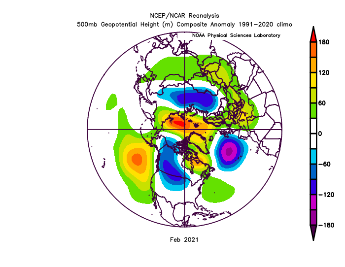
An example where the CPC metric seems a bit fraudulent. I do remember that Davis Strait block too which helped out in the Feb 1-2, 2021 firehose storm.
-
At ORH, those 9 Februarys averaged 24.0" with a median of 20.6".....longterm average for February at ORH is 17.1".....so it was prolific down this way as well. January has really been the more recent turd in the punchbowl for around here with 5 out of the last 7 below normal snowfall in ORH...and the two that were not below normal had massive cutters that ruined the overall feel of the month.
-
It's comparing both to the 1991-2020 climo but that is irrelevant when they are subtracting the anomalies from eachother since the '91-'20 portion of the subtracts itself out to zero and you are left with 2021 compared to 1951-2010 as the only remaining difference.
-
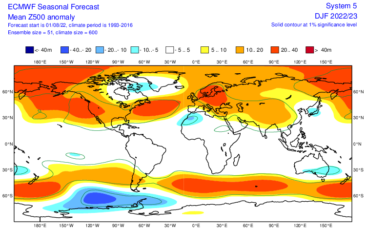
Make sure you have August as your base period https://apps.ecmwf.int/webapps/opencharts/products/seasonal_system5_standard_z500?area=GLOB&base_time=202208010000&stats=ensm&valid_time=202209010000 Then it should go out to DJF.
-
Yeah its hard to analyze it when it's spitting out conflicting patterns....rarely gonna get a fat monster W ATL ridge without a deeper trough somewhere to the west.
-
Congrats Baffin Island
-
With more data available than ever before, rigorous statistical analysis is imperative, and many statisticians will tell you that there has been a degradation of using data properly...even in published literature. You gotta watch for p-hacking and other incorrect use of data and it's not easy to do if you aren't actively looking for it all the time. Even in very informal settings like on this forum, we will often use metrics and methods that are not very useful for comparing datasets. The one I probably mention the most as being flawed is "percent of average snowfall"...usually powderfreak and I make the comments on it. Comparing different locations using that metric is worthless by itself since different areas will have different season to season variance. It's not that weird to get 200% of mean snowfall in the mid-atlantic but it just does not happen in northern new england (or even parts of interior SNE....like ORH). So we need to normalize the datasets by using standard deviations, but using Stdev isn't very popular since most people aren't familiar with it outside of maybe learning about it in math class one time eons ago.
-
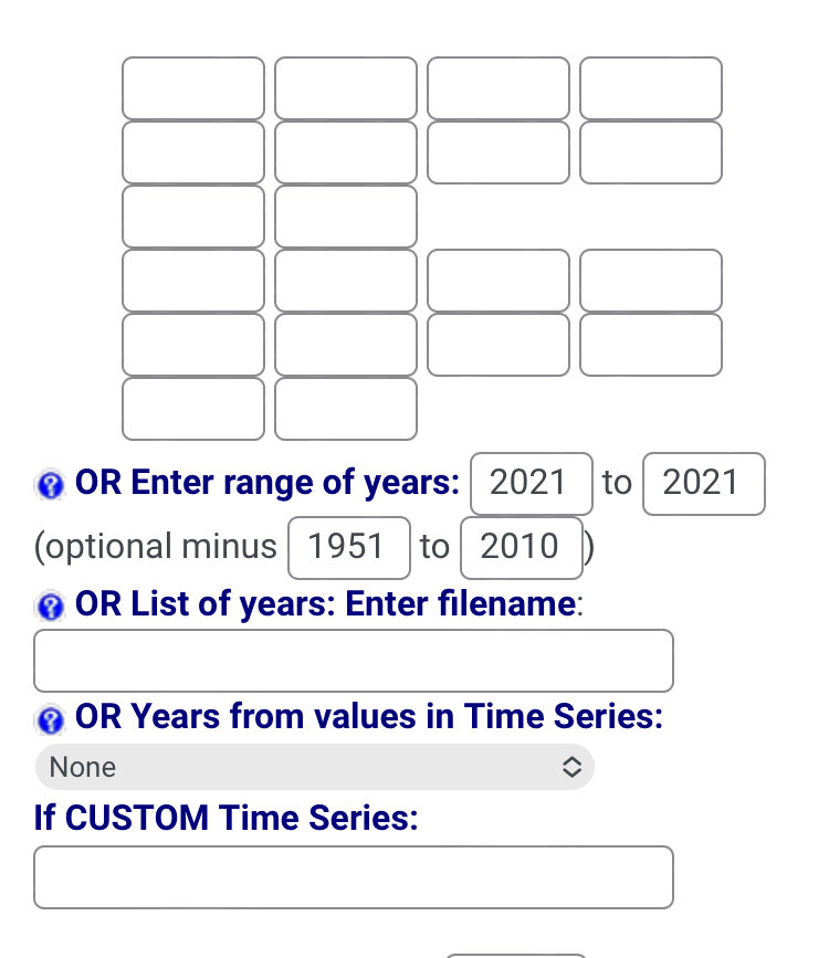
You can use the subtraction comparison feature to regenerate the baselines from earlier. The only drawback is you can’t do a composite unless it’s a range of years in consecutive order. Like for example, if you wanted to compare 2021 to the 1951-2010 baseline, you’d enter it like below: There might be a way to do a composite of years against a custom range….that might be under “custom” time series….but I haven’t tried it before.

-
My guess is it peaks around -1 which is near the line of moderate and weak. I don't think it matters too much whether it's -0.9 or -1.2.....really only if it gets several ticks stronger than that. I wonder if the MEI will rise next update because I have noticed the PDO is rising quite a bit in the past week or two.
-
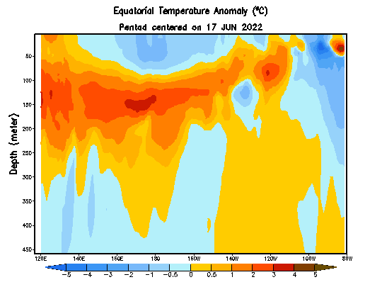
Yes. Only thing that might prevent the really cold stuff from surfacing is that so far the easterlies are having a hard time getting east of 150W or so. But even getting the good easterlies to 150W, that is far enough to cause some good upwelling into Nino 3/3.4 anyway.
-
Update: On 8/21, NSIDC SIA was 3.93 million sq. Here's how other post-2007 years compared on the same date: 2021: -300k 2020: -1.09 million (-1090k) 2019: -870k 2018: -300k 2017: -540k 2016: -820k 2015: -380k 2014: +320k 2013: -30k 2012: -1.18 million (-1180k) 2011: -780k 2010: -100k 2009: +190k 2008: -270k 2007: -900k
-
Yeah that is correct....but those subsurface anomalies are no slouch. They are very cold so I'd expect Nino 3 and 3.4 to really cool over the next month or so barring a reversal in guidance on the easterlies.
-
The only issue I have with the ECMWF forecast is it doesn't look like it's matching empirical reality early on. The Nina is def not going to steadily weaken in the next few weeks. I'd bet on strengthening looking at these graphs

-
You basically had the equivalent of widespread F2 tornado damage between BOS and CT river. That’s catastrophic.
-
If another ‘38 hit, we’d prob be out for a month outside of the densely populated areas right near cities. They’d prob get most of those back within a week or two but far suburbs/exurbs and beyond would take quite a bit longer. The sheer volume of tree damage to clear away would be the biggest limiting factor to restoring the grid.
-
Yeah though my gut says it’s not gonna be weak. We will have a better idea after the winter on how well that warm pool has maintained. But who knows. 1976-77 was a weak Nino and that was coming off a 3 year Niña.
-
That's a good look though at least....we want the western region to warm while eastern region cools. That warm pool out west in the subsurface is probably the fuel for El Nino in 2023-2024....
-
Last two 3rd year Ninas weren't that bad....2000-2001 (which was historic further north in the interior, but still good where you are) and '75-'76 (maybe near avg there, but pretty good further northeast).
-
I did take more time off this summer than usual though....I usually still consistently post in summer, but just a more infrequent rate. I basically went 2 months without posting at all, but it was good for me since work was getting a bit much during late spring/early summer and then we had a busy family vacation schedule mid-summer. There really was nothing to post about either wx-wise most of this summer. I made some posts in the arctic sea ice thread occasionally but not in here. With ENSO starting to become more defined, I started posting in the winter thread earlier this week. But yeah, there was a time back on eastern when many of us would disappear almost the whole warm season.
-
Rubber band snaps and we get a ton of storms in fall and winter.
-
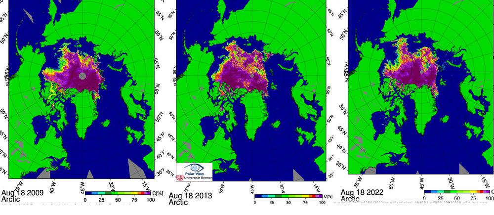
I decided to compare the other 2 closest years to this one to see if we can try and gauge how close we will finish. 2009 and 2013 are both within 10k of 2022 for sea ice area. At first glance to me, I think 2022 has more vulnerable ice than both of those years. 2022 has a more pronounced "arm" of ice into the ESS than those years had and that arm is usually vulnerable to additional melt into September if other years are any gauge. The one offsetting factor might be lower concentration ice really high in latitude near the pole....this will refreeze into 100% concentration ice very quickly in September even as the "ESS arm" continues to melt. So this would help offset the East Siberian losses at least partially. 2009 min was 3.55 million sq km and 2013 min was 3.61 million sq km. My guess is 2022 finishes below both of these, but I think it's very likely we'll finish higher than 2018 which was the 4th highest finish (3.23 million sq km) since 2007 only behind 2009, 2013, and 2014.....btw the latter year, 2014, had a big falloff from it's current position to finish in between 2009 and 2013 at a min of 3.58 million sq km.