ORH_wxman
-
Posts
93,092 -
Joined
-
Last visited
Content Type
Profiles
Blogs
Forums
American Weather
Media Demo
Store
Gallery
Everything posted by ORH_wxman
-
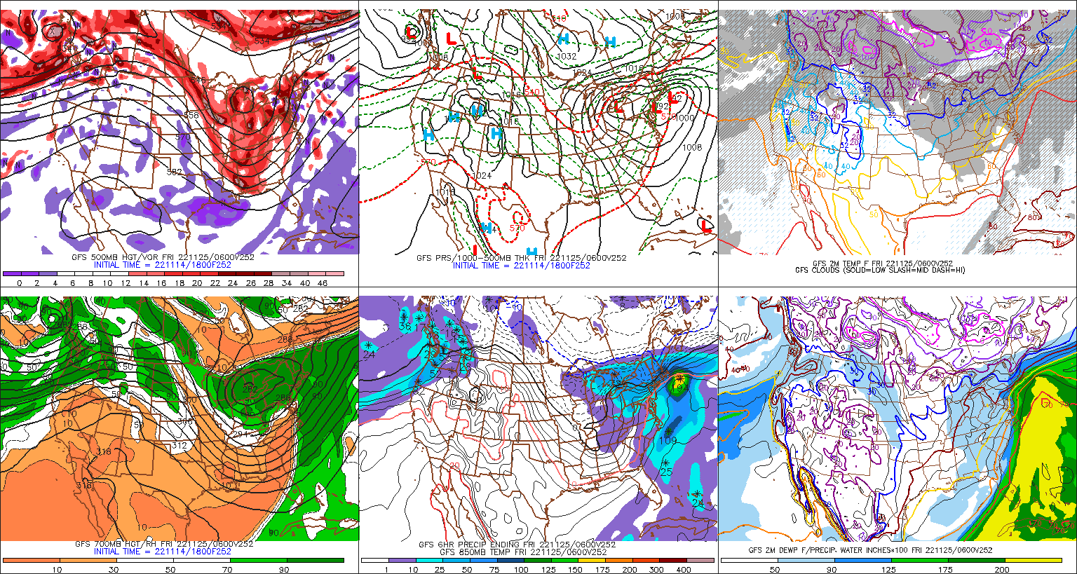
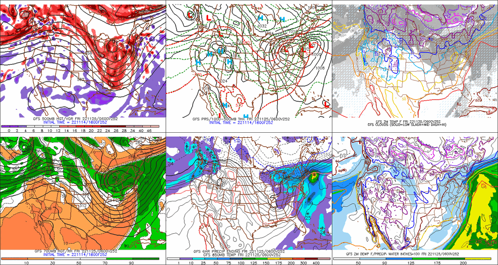
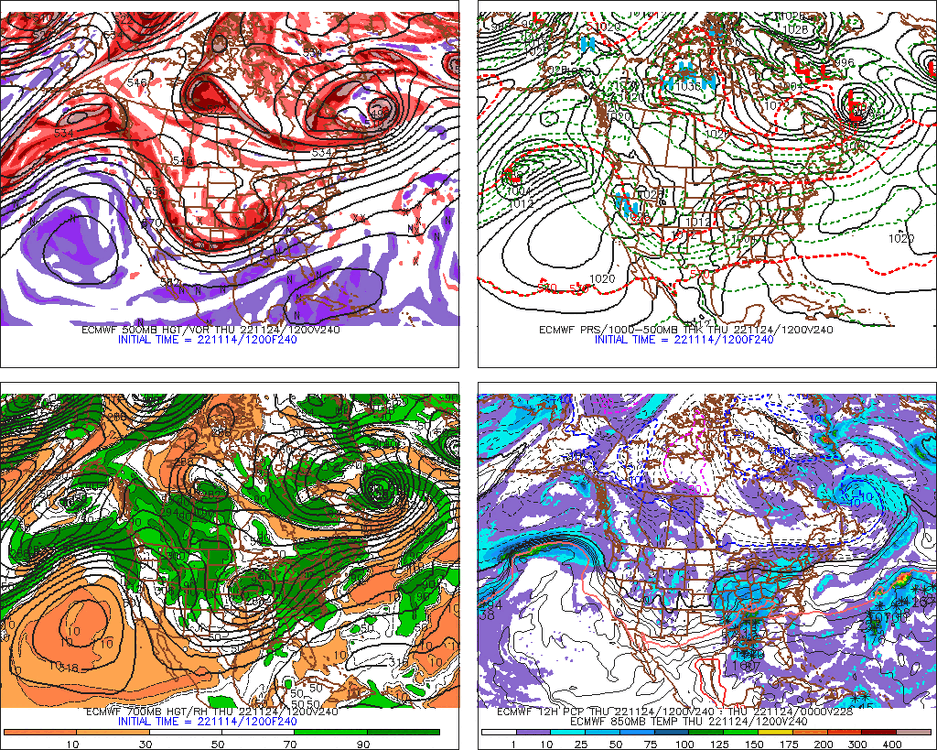
Big model differences between NAM and other guidance for tonight. Most other guidance prob gets like an inch or so (maybe even 2”) down near ORH while NAM would maybe start as a couple flakes before very quickly flipping. 18z NAM gets the mixing north of the VT/Canada border. 18z HRRR and 18z rap are still defying the NAM.
-
Yeah and Killington has already proven it can handle that race for several years now (I think since 2016 or 2017?). From memory, most years have had very good conditions.
-
That average snowfall map is horrific.
-
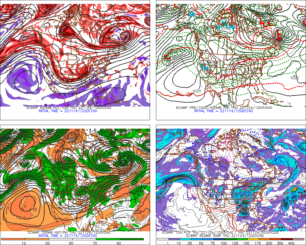
It’s not a super strong block on most guidance right now so I’d probably hedge warmer like the euro look. But can’t rule out the colder scenario. A lot will depend on how the EPO block breaks down…on some of the colder CONUS looks, it pinches off and retrogrades up into the AO region and strengthens the block which would produce a colder look Tday week/weekend.
-
@Damage In Tolland 18z GFS shows how to get it more wintry for Tday. Nice sleet bomb on this depiction
-
More likely to be rain or nothing....but if we're playing devil's advocate, you want that NAO block a bit more stout to push that system underneath us.
-
Oh nice....earlier in this thread there was talk of an "inspection" on Saturday 11/12 by FIS officials, and I was worried it would be so bad they'd cancel without realizing the next 2 weeks looks great for them.
-
Sounds good for retention but pretty terrible for orographics on heavy precip.
-
Weeklies backed off the furnace December....still show a bit of a relaxation in early December but it flips back to a colder pattern for second half of the month. But honestly, they haven't been consistent or skillful at all so far this cold season out beyond week 3 so not gonna put much stock into it....even if we like the holiday period pattern it shows.
-
Lol, ninja'd....your pattern recognition in the last few years has improved exponentially.
-
Prob a lot of clippers and SWFEs....you typically want a big western ridge for large coastal storms....but that type of pattern can also produce some miller Bs (Jan 12, 2011 was an extreme example of one)
-
A good analogy is it's like on a new car where they have the anti-collision system and rear-view camera for backing up....that's what the splitting of the PV aloft is adding. It helps, but there are still a hundred variables more important in being safe on the road than just having those features. All else equal, you'd rather have them than not.....but they aren't going to make a terrible driver safe. The stratospheric PV split just makes resistance to blocking a little less, which is good. But we don't want everyone to start throwing a party just because it shows up. It is still minor in the scheme of things.
-
It has shown up a couple times on various model runs, but it doesn't have anything close to widespread ensemble support. Certainly nothing thread-worthy.
-
All about rates....if it's SN- at 33F for 2-3 hours, it's gonna be mostly coatings to an inch...but if you can sneak in an hour of SN or SN+ at 31-32F, then there will be some 2" amounts prob.
-
I hope they didn't cancel the Cup at Killington because of that.....looks great for them the next couple weeks. Both man made and natural snow should be plentiful.
-
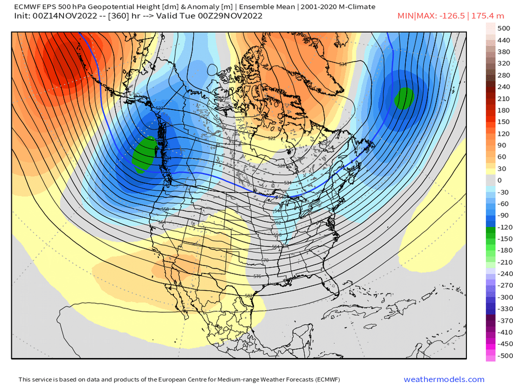
You can see the AO/NAO trying to ramp up on the EPS. We lose the PNA ridging out west but at least we still have cross-polar flow via the -WPO. This pattern isn't super cold, but it's not warm either. Prob a lot of chances in that type of pattern if it holds into December.
-
That sounding looks like the precip is ended.....completely dried out in the mid-levels.
-
Yes. Even back in the day in ORH I sometimes felt a little neglected by Boston Mets but it wasn’t nearly as bad as areas NW of ORH put toward ORE.
-
I dunno, I always had Syracuse at the top of my mind when I made forecasts for interior New England.
-
It probably would’ve helped the artist if they used a map that didn’t cut off a third of Maine.
-
Apparently the monadnocks aren’t interior New England. And all that time when I was issuing forecasts I never knew…..
-
Yeah we’ll see. We still may get a little event. Just because models don’t have one at day 8 or 9, doesn’t mean one can’t pop up.
-
Sure it does normally without any context with it, but his context was “NNE and maybe into interior SNE” which means you’re looking at the northern part of SNE. I really wouldn’t get hung up on it. We might get an event and we might not. But latitude is really favored this early. Even places like CON and southeast NH at lower elevation average more snow in November than ORH hills even though the latter averages more in a season…the interior elevations further south just make up for it later on.
-
You gotta translate DIT posts into his language. If he’s only thinking a 1-3” event might happen, it really means some flurries and maybe a few snow showers.