ORH_wxman
-
Posts
93,099 -
Joined
-
Last visited
Content Type
Profiles
Blogs
Forums
American Weather
Media Demo
Store
Gallery
Everything posted by ORH_wxman
-
Kevin this might be the paster you’ve been waiting for.
-
Def morphing into an interior SNE/CNE deal. You don’t get that second round of deepening that was crushing SE areas on some of the runs yesterday.
-
It was a Flop... February 2024 Disco. Thread
ORH_wxman replied to Prismshine Productions's topic in New England
1958 stayed great almost to the end. The big dog HECS was around the equinox. -
Someone who is not on a phone can prob toggle EPS to see if they moved…but they look really close to 00z just eyeballing…maybe the smallest tick SE


-
Up to 47 here. Might be able to sneak in a warm day today at least in this area though that frontal boundary is lurking not too far north of the pike and it’s going to sink back south at some point.
-
I’m still expecting a push north at some point given it’s a southern streamer. It’s possible we have a bunch of turd southeast scraper solutions and everyone here cancels the threat and then it comes back N….or maybe it starts at 12z.
-
Yeah my confidence in the euro is shook a bit. A few years ago I’d probably be getting pretty gung ho.
-
Yes, it’s pretty rare to see 6”+ that high at d4-5. But I don’t have that type of confidence at all in this one yet like those probs would normally imply.
-
There’s some that would dump 12+ over a good chunk. At least this system has upside. Better than tracking one where we’re hoping for 2-4” like it’s 1988-89 with Bruce Schwoegler honking for 5”+ if you include the squalls the next day.
-
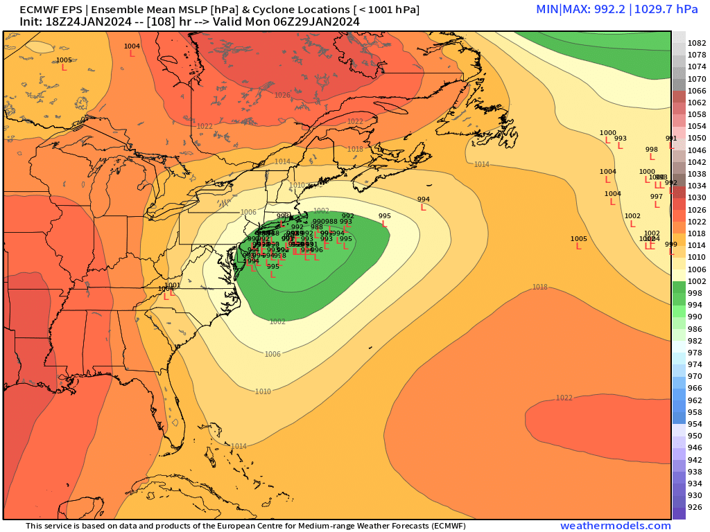
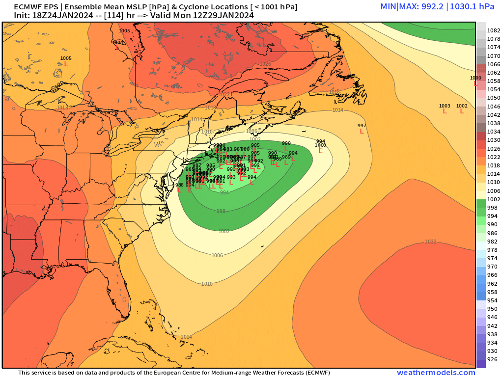
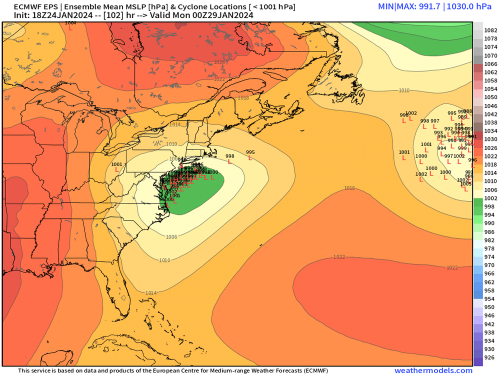
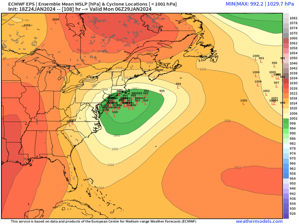
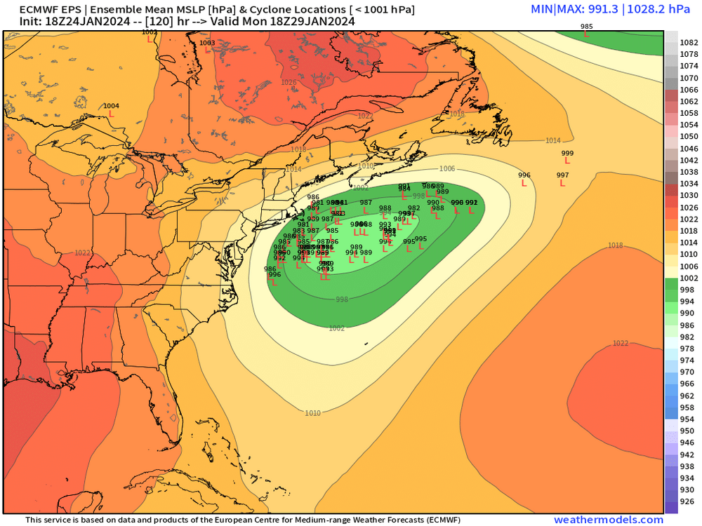
Here’s 18z eps. Getting close enough now that these are going to start being decent to track

-
No he’s in the monadnocks in NH.
-
Charles River actually freezes pretty easily. I saw people out in it even in a moderate winter like 2020-21. But yeah, we’re not getting many 77-78 type temps these days.
-
Anyone with over 4" has a decent chance of keeping it....but this 2-3" of thawing glacier won't survive I don't think...maybe in patches....we're onto 1/29.
-
They’ll slowly climb. But you may have trouble breaking 40 up there even tomorrow. 18z NAM even canceled the 50s for CT tomorrow.
-
33.5 and drizzle. Most of the snow finally gone off the trees.
-
It was a Flop... February 2024 Disco. Thread
ORH_wxman replied to Prismshine Productions's topic in New England
The EPS has been evolving into a psuedo Hudson Bay block....it's still a solidly AN pattern for us, but perhaps not the spring fever preview where we get 60s. We stay on the east side which keeps us colder and it never really gets far enough east to give us the return flow...perhaps cold enough for continued winter threats (ala the Euro and GFS on 2/1-2/2 which are already appearing today)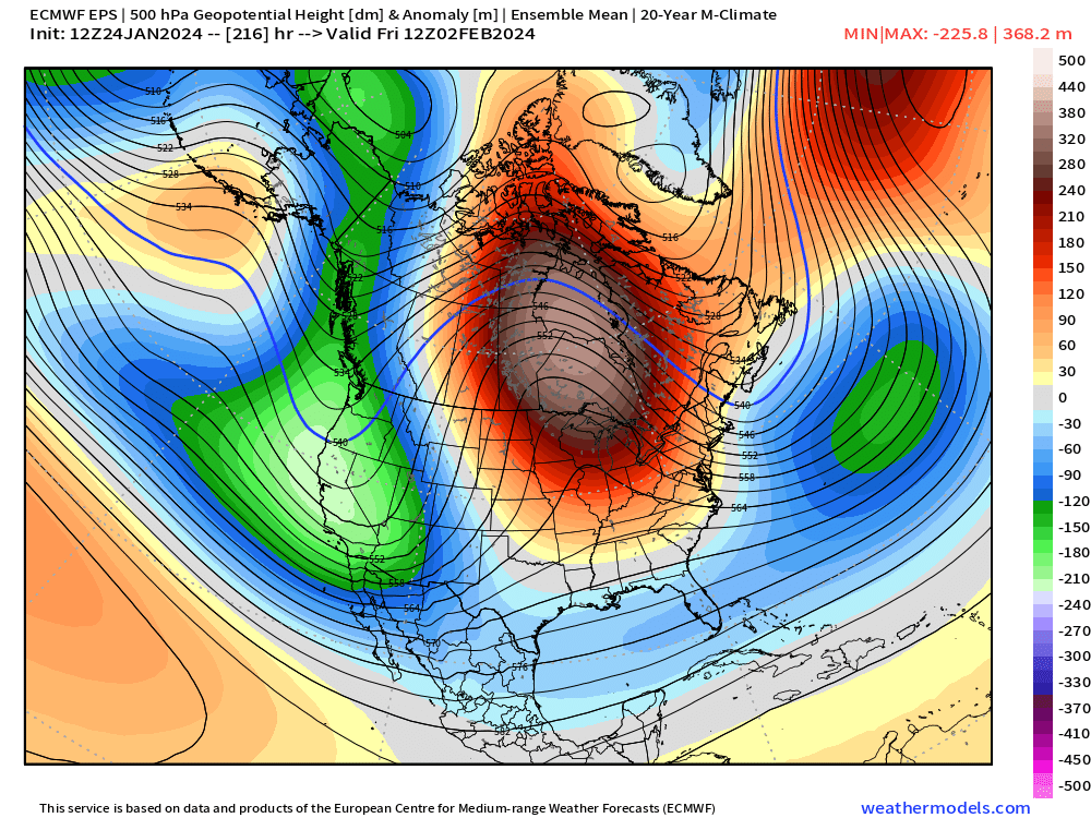
-
It was a Flop... February 2024 Disco. Thread
ORH_wxman replied to Prismshine Productions's topic in New England
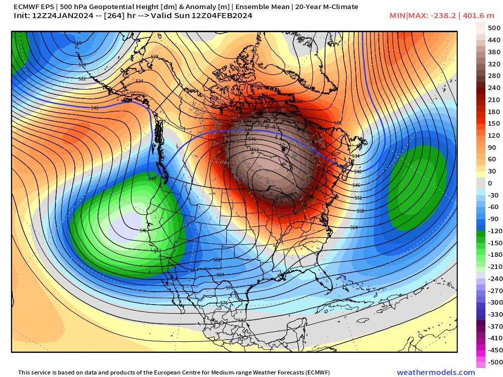
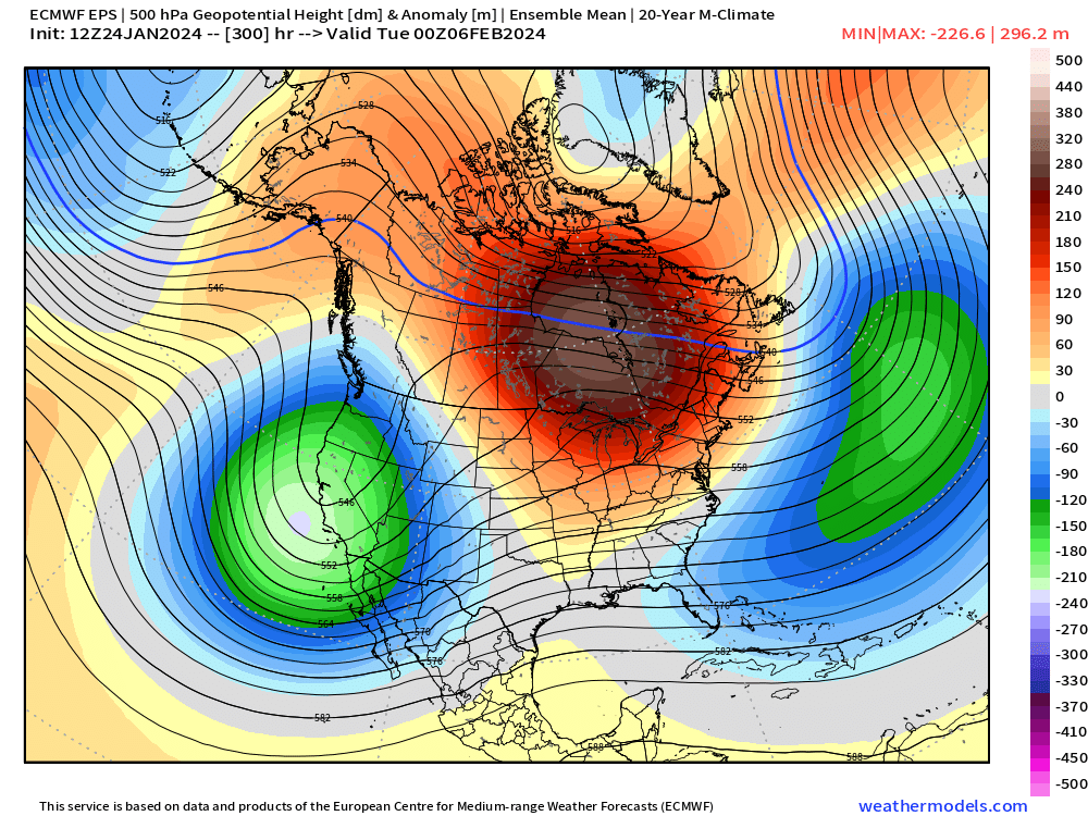
This is the type of pattern where being in a potent El Nino might actually help...we don't have that saturated geopotential medium with a trampoline to our south....so we can dig for oil on the east side of that central CONUS trough. -
It was a Flop... February 2024 Disco. Thread
ORH_wxman replied to Prismshine Productions's topic in New England
Ran from your basement....south shore shlong again on the CCB of that little clipper-redeveloper. -
I'd def want it a bit compressed right now...southern stream juicer coming out of TX/OK. I also don't want any more rain, lol.
-
I think you'd do better with it a bit more amped...all those CCB goods to your SW in PA would get you. OBviously don't need the low crawling into NY/LI, but a bit more N before getting shunted east would prob be more violence for W CT.
-
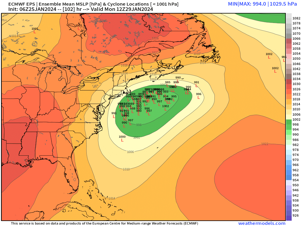
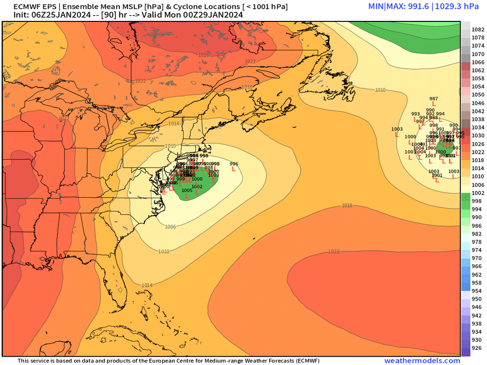
It's fighting the confluence at the end and it gets crunched a bit, but still a very nice event for most of SNE. It's in a pretty good spot at 4.5-5 days out since a bump north is fine from this position.
-
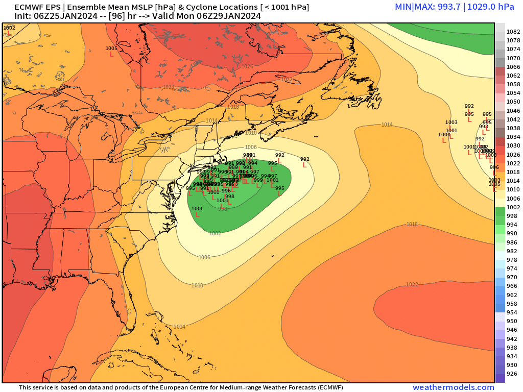
I think this run might be pretty good. If it misses, it's gonna be SE, but I think it might have enough looking at 96-102h.
-
Yeah its a race against the sfc front pressing down tomorrow...we may not win that race here. Maybe we can "score" a few hours of decent weather in the PM if we thread the needle. Friday is awful....typically don't bet against BDF/wedge climo.
-
Ukie is a nice hit for SE MA/RI...Cape really gets it. Advisory back in the interior east of the river.
-
Trees still mostly caked....though a little bit of fall off branches compared to earlier. Everything pasted for most of the morning. Temp has been really slow to climb....32.5F right now.