

ORH_wxman
-
Posts
93,092 -
Joined
-
Last visited
Content Type
Profiles
Blogs
Forums
American Weather
Media Demo
Store
Gallery
Everything posted by ORH_wxman
-
It was a Flop... February 2024 Disco. Thread
ORH_wxman replied to Prismshine Productions's topic in New England
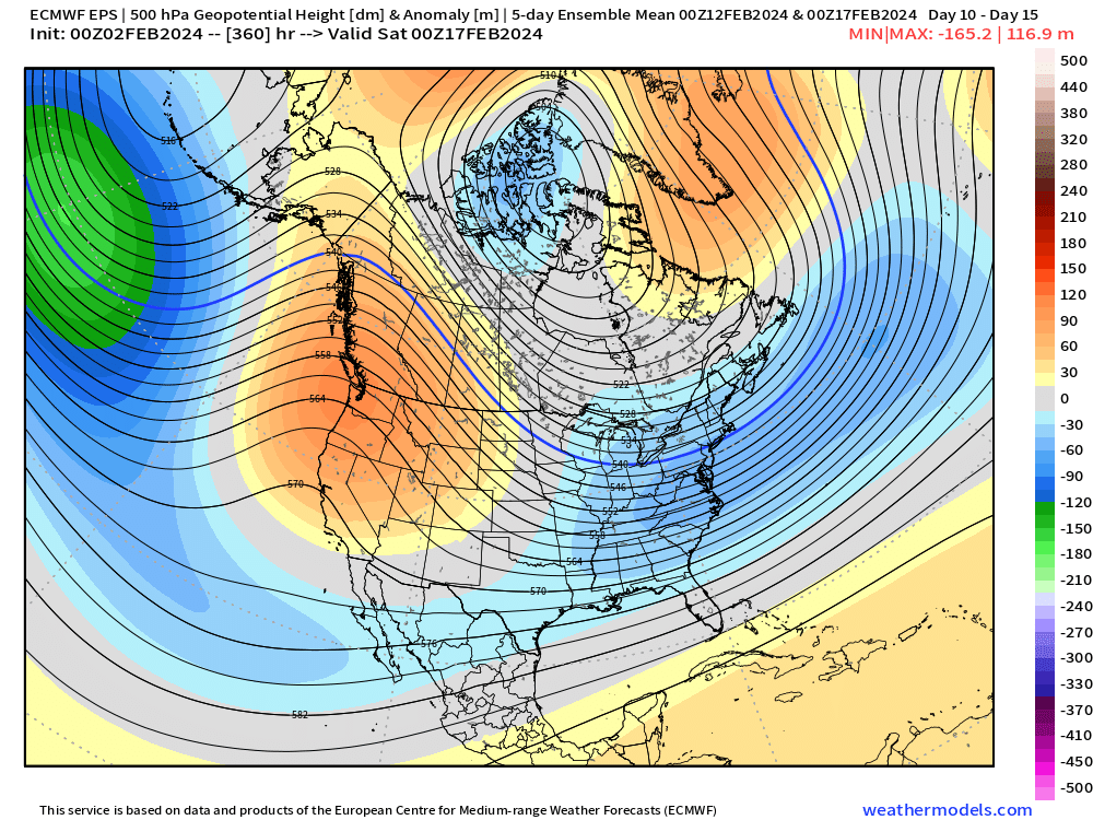
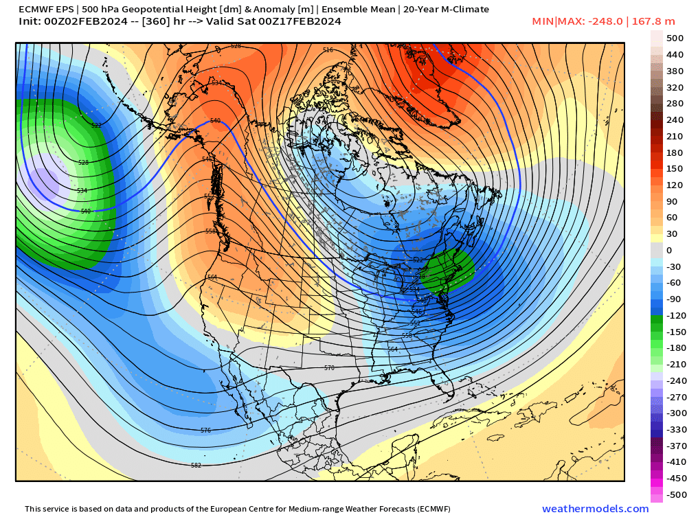
Yeah I do like that it’s not a really fast “in and out” pulse…the longwave pattern is amplifying for most of that week in the middle of the month. It offers a nice background assistance to anything that wants to try and develop to our south. It’s the type of look where you might see a storm on guidance that you can track for over a week. Of course, it could also be the type of pattern where it can’t decide which shortwave to focus on and we end up with another shit sandwich. But I’m hopeful that spacing interference will be harder to achieve because the background PNA ridge is going to try and force the issue more than the baseline would. -
It was a Flop... February 2024 Disco. Thread
ORH_wxman replied to Prismshine Productions's topic in New England
What’s interesting on the 12z GEFS (and EPS was showing this as well) is that the western ridge is amplifying the entire time once it starts around D10-11. So that means you could have any number of shortwaves during this period be prone to big cyclogenesis….that’s a constructive interference look there rather than a de-amplifying ridge providing destructive interference.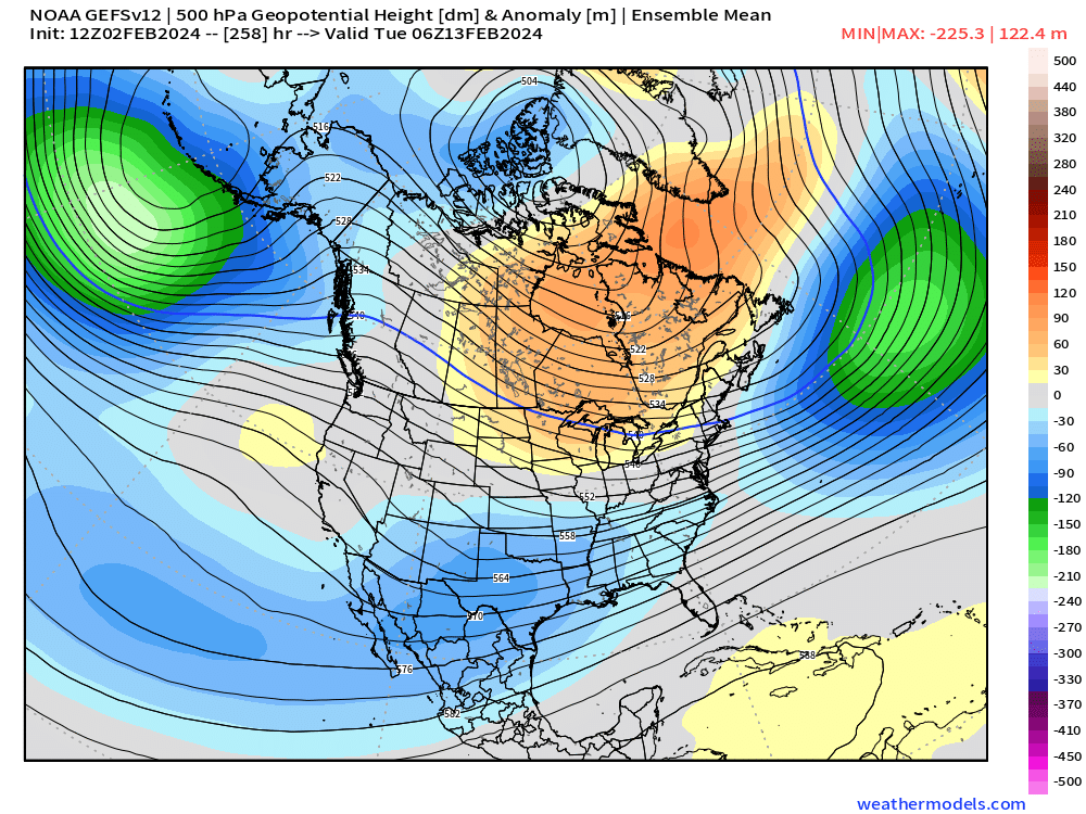
-
It was a Flop... February 2024 Disco. Thread
ORH_wxman replied to Prismshine Productions's topic in New England
Yeah this is typically a massive bright spot on the historical calendar for major snowstorms…esp during El Niño. But we’re going to get zippo over the next 10 days. The irony too is the last week of February is a historical min so we’re going to have to break that trend if we want to play catch-up unless we land a monster in the Feb 13-20 range (entirely plausible). Yeah, there’s been exceptions like the 100 hour storm in late Feb 1969….but it’s surprisingly devoid of major storms considering mid February and early March are hotspots. -
It was a Flop... February 2024 Disco. Thread
ORH_wxman replied to Prismshine Productions's topic in New England
Yes. That’s why I like the look so much…it risks some huggers/inland runners but it has Atlantic blocking to try and counteract that. It’s a very good look. I’m sure we’ll talk about the thousands of ways we can roll snake eyes as we get closer or the pattern progged unravels, but as of now, that’s a look we want. Active/cold/somewhat stable. -
It was a Flop... February 2024 Disco. Thread
ORH_wxman replied to Prismshine Productions's topic in New England
Yeah you could prob push everything out a week now that we have a better idea of what guidance looks like. Biggest unknown left this season (aside from actual snowfall since you can’t predict nuances) is how long does that favorable longwave period last. Is it 2 weeks and then early spring? Or does that blocking developing into a self-sustaining prophecy that takes us to the equinox? Hard to say…maybe it’s in between too and takes us to around 3/10-3/15. -
New England Seasonal Snowfall Historical Records
ORH_wxman replied to weatherwiz's topic in New England
So the problem is snowfall is not a normal distribution. It has a high tail because of the fact we can’t have negative numbers on snowfall. So the easiest way to exclude outliers equally in a fast/crude manner is to put your entire array of values in a column on excel (you prob already did this)….now go to “formulas” tab on the top of the spreadsheet and go to the drop-down menu that says “more functions” and then go to “statistical” and then scroll all the way down to “Percentile.exc”. Once you do that it’s going to ask you select the array of values, so click on the first value of your snowfall total, hold shift, and then select the last value so that it includes all of them in the array. Now, below the array line there is a “K” value. For your 10th percentile value, type in “0.1” and you should see a low-ish snowfall value appear below the K line on the right. That is your 10th percentile snowfall value…write it down or type it someonewhere . Now do the same thing for 90th by inputing “0.9” for the K value. Once you have have your 10th and 90th percentile values, you can toss all values above the 90th and below the 10th if you want to exclude outliers in an even manner. This gets rid of the problem of trying to use methods you’d normally use for a normal distribution. Now you could do this for any percentile value you wanted. If you wanted the 50th percentile, you type in 0.5 into the K line…for 25th you input 0.25….you get the idea. -
It was a Flop... February 2024 Disco. Thread
ORH_wxman replied to Prismshine Productions's topic in New England
Now we know the weeklies are actually going to be correct and we’re gonna rip snow bombs into the equinox like its 1958. -
New England Seasonal Snowfall Historical Records
ORH_wxman replied to weatherwiz's topic in New England
I’m surprised there were no -10 inch snowfall seasons. -
It was a Flop... February 2024 Disco. Thread
ORH_wxman replied to Prismshine Productions's topic in New England
Yeah if we can set up a true blocking episode…it will help prolong the favorable look so that maybe we have longer than just a 7-10 day window. I’m skeptical until it’s right in front of us. Weeklies do try and run with that blocking and take us well into mid-March at the end of their run still with a favorable look. Not that any of us should trust the weeklies. -
It was a Flop... February 2024 Disco. Thread
ORH_wxman replied to Prismshine Productions's topic in New England
Pattern mid-month still looks excellent. But it’s pretty much snoozefest for 10 days before that…only question is whether we can sneak a 60F nape tanner or two in there at the end of next week/weekend. But the pattern beyond that is still about as good as you could draw it up.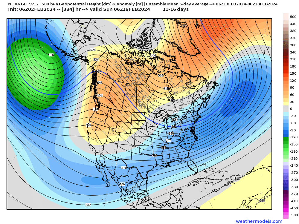
-
It was a Flop... February 2024 Disco. Thread
ORH_wxman replied to Prismshine Productions's topic in New England
Yeah there were three of them that always teamed up and reported totals within an inch or two of eachother in those bigger storms. And they were always higher than everyone else in that area. -
It was a Flop... February 2024 Disco. Thread
ORH_wxman replied to Prismshine Productions's topic in New England
Positive bust too. Was supposed to be like 8-12” and a slot but at the last second the rgem scored the coup on secondary development which prolonged the snow into afternoon and early evening. -
It was a Flop... February 2024 Disco. Thread
ORH_wxman replied to Prismshine Productions's topic in New England
4th biggie kind of missed you too on 2/15 -
It was a Flop... February 2024 Disco. Thread
ORH_wxman replied to Prismshine Productions's topic in New England
Yeah the amplitude on these runs is pretty extreme for a D12-15 ensemble prog and it’s across all guidance too…not just one set of ensembles. I think the pattern shift is basically inevitable at this point but the bigger question is how long it lasts and if it trends more amplified or less. If you only get a 7-10 day period of favorability, then you can more easily whiff on storm chances versus if you get 3-4 weeks…just obvious probability/statistics. -
It was a Flop... February 2024 Disco. Thread
ORH_wxman replied to Prismshine Productions's topic in New England
There is no doubt there is a very strong consensus for a more favorable pattern by mid-February. Details TBD and of course nobody in here cares unless it produces a deformation band over their noggin….but the current evidence is that the pattern will become quite favorable for colder/stormy….it could deteriorate as we get closer but there’s nothing yet that would make me actually predict that outside of “vibes”. -
There’s def a big difference over just 100-200 feet of elevation. The lowest parts of town have less than half of what we have here.
-
Not as much as N ORH county and monadnocks but quite wintry here today still as well.
-
It was a Flop... February 2024 Disco. Thread
ORH_wxman replied to Prismshine Productions's topic in New England
Scooter is full throttle back to shore to set the market with 60,000 pounds of swordfish on board….he doesn’t care if the Perfect Storm is in his tracks. He’s gotten his second wind with the Hail Mary coastal storm on the GFS next week and then the ensemble going full weenie pattern by mid-month….he’s gonna fight and not lay down in the woodshed.
-
It was a Flop... February 2024 Disco. Thread
ORH_wxman replied to Prismshine Productions's topic in New England
Yeah this is a weird temp pattern for a strong Nino January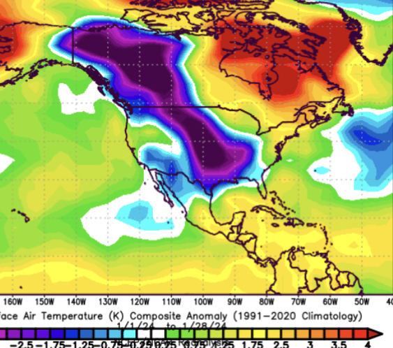
-
It was a Flop... February 2024 Disco. Thread
ORH_wxman replied to Prismshine Productions's topic in New England
Yep. But if the first 10-12 days of the month is bone dry, that wouldn’t be too bad for the second half of the month. If we finished the month an inch below normal on QPF but almost all of the precip falls after the 12th, we’d take that in a heartbeat. -
It was a Flop... February 2024 Disco. Thread
ORH_wxman replied to Prismshine Productions's topic in New England
Seems like next weekend (about 9-11 days out) is the period to watch if we’re gonna sneak in some true torch days in the 50s or higher. At the moment, most guidance seems more muted but could change as we get closer. If that pattern beyond that keeps showing up without degrading, then I’ll become more enthusiastic for a potential larger snow threat. Pretty crazy ridge showing up out west. -
It was a Flop... February 2024 Disco. Thread
ORH_wxman replied to Prismshine Productions's topic in New England
Scooter getting sucked back in. Might be some south shore goodies with that colder airmass and onshore flow next week and then after that the ensembles showing a loaded pattern by mid-month.
-
Yeah Edgemere area is right on the Shrewsbury/ORH line on rt 20 on the southern tip of Lake Quinsigamond. It’s basically the lowest point in Worcester proper.
-
Oh that was the big fluffer bust. Like Walpole to Taunton had 8”+ when the forecast was like 2-4”. A thin band late that evening started from me to Ginxy and nobody else was snowing. Then things finally expanded overnight and it went to town over SE areas with pristine snow growth and it ended maybe middle of next morning. Almost a mini 2/7/03.
-
Holden is a great spot. Retention there is night and day compared to even lower areas of Worcester. It’s why I often say ORH can be sliced in half in the city. The NW side from Indian Hill to Winter Hill on the Holden line over to Salisbury area over to Tatnuck square and ORH airport are way different than downtown to Webster square. You can go even weeks at times where there will be deep pack in that area while Webster square has patches of bare ground.


