

ORH_wxman
-
Posts
92,879 -
Joined
-
Last visited
Content Type
Profiles
Blogs
Forums
American Weather
Media Demo
Store
Gallery
Everything posted by ORH_wxman
-
December 2024 - Best look to an early December pattern in many a year!
ORH_wxman replied to FXWX's topic in New England
12/5 produced a lot of events in the past (2002, 2003, 2009…even 2020 had the interior elevated paste job on 12/5). -
December 2024 - Best look to an early December pattern in many a year!
ORH_wxman replied to FXWX's topic in New England
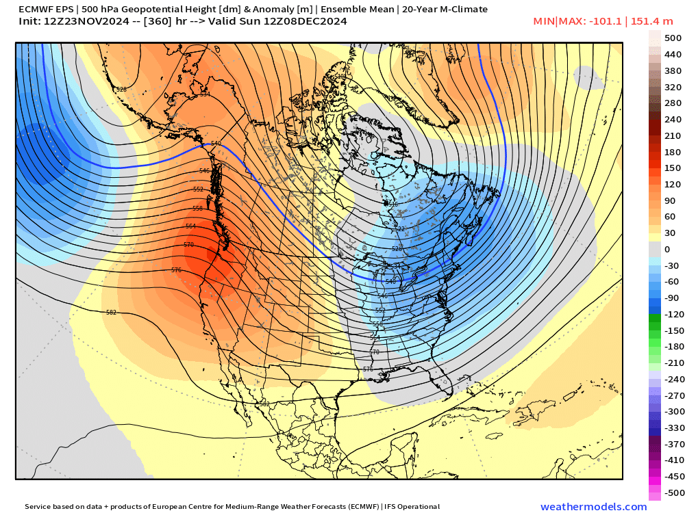
It’s been a long time since we’ve had this type of consistently BN temps showing up on ensembles…esp in December but really anytime winter since prob 2021. EPS really is hammering the cold down. GEFS not quite as hard but still BN for the foreseeable future once we get past Friday. Usually the snow chances start manifesting when we get this type of cold in December. Hopefully that happens this time as well. -
December 2024 - Best look to an early December pattern in many a year!
ORH_wxman replied to FXWX's topic in New England
For selfish reasons, you’d prob welcome some solid cold before too much snow gets laid down in the foothills. Get everything frozen up solid before riding season. Prob the best early-season cold pattern we’ve seen in years…not that the bar has been set very high the last 5 years. But consistent cold in December has been hard to come by since 2017. -
December 2024 - Best look to an early December pattern in many a year!
ORH_wxman replied to FXWX's topic in New England
12/5 period (give or take a day) still the first one to watch for larger chunk of SNE imho. You have a developing PNA ridge that increases in amplitude quite significantly between about 12/3 and 12/6…so that is a potential flag for northern stream digging down into the mean trough in eastern US. Pretty good antecedent airmass would be in place unless the pattern dramatically changes on guidance. -
Blowvember - and not named for wind potential
ORH_wxman replied to Go Kart Mozart's topic in New England
Weak system with bad antecedent airmass. Sell clowns big time. Esp below 1000-1200 feet. TPV got stuck almost due north of us which is not where you want it. You want it east toward the 50/50 region to get a high building in. That is the main change from some of those colder solutions 3 days ago. -
December 2024 - Best look to an early December pattern in many a year!
ORH_wxman replied to FXWX's topic in New England
Yeah the MJO would suggest nothing like we’re seeing on model guidance. There’s a pretty big PNA ridge spike shown at around D11-12 that occurs so I’m wondering if that 12/5 period give or take a day is something to watch for a larger scale system. Much more pronounced on EPS than GEFS but still there on the latter. -
December 2024 - Best look to an early December pattern in many a year!
ORH_wxman replied to FXWX's topic in New England
That WPO has been such a persistent turd and it’s amazing how positive the EPO was last winter too despite it often being progged negative or neutral. It wasn’t as positive as the WPO but that WPO always ended up bullying it so it went positive too…and solidly. Let’s hope this year is different. -
Blowvember - and not named for wind potential
ORH_wxman replied to Go Kart Mozart's topic in New England
I experienced one in the texas panhandle one time. Was up in Dalhart, TX and there was a very strong synoptic wind event and it was relentless. There’s no trees to stop anything out there in the high plains. Just constant battering of 40-50 and gusts way higher. -
December 2024 - Best look to an early December pattern in many a year!
ORH_wxman replied to FXWX's topic in New England
@CoastalWx Weeklies are starting to cave for 3rd week of December. Previously showing a kind of torchy pattern but it’s keeping that ridge in the west now which delays the warmup. Don’t worry, I’m sure it will flip just in time for a grinch cutter. But interesting to see nonetheless given what we see at the end of the ensembles recently. -
Blowvember - and not named for wind potential
ORH_wxman replied to Go Kart Mozart's topic in New England
Often our best wind events over interior SNE are backside CAA in winter/cold season. We can rip on those. -
Blowvember - and not named for wind potential
ORH_wxman replied to Go Kart Mozart's topic in New England
Only chance of that happening is the PV lobe pushing further SE than currently progged and then sharpening that shortwave just enough to bomb it on the coast. Theoretically plausible but very unlikely. -
Blowvember - and not named for wind potential
ORH_wxman replied to Go Kart Mozart's topic in New England
That’s an upstate NY special on GFS. Does match climo a lot better than an SNE snowstorm. Still hope it comes back SE though. Would be nice to even just get on the board with small accumulations. -
Blowvember - and not named for wind potential
ORH_wxman replied to Go Kart Mozart's topic in New England
Yeah that seems the most likely. Though can’t rule out something smaller embedded around the TPV. -
Blowvember - and not named for wind potential
ORH_wxman replied to Go Kart Mozart's topic in New England
Prob need to start a December thread but EPS not backing down on the PAC pattern. Really consistent with holding that ridge axis right over the west coast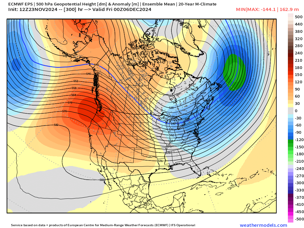
-
Blowvember - and not named for wind potential
ORH_wxman replied to Go Kart Mozart's topic in New England
Last December we were relying on a huge progged NAO block. Those are inherently less stable than N PAC pattern…they have a more stochastic behavior. That’s also probably why you hear a lot of Mets say “I’ll roll the dice with a great PAC look any day”…those tend to verify more than random huge NAO blocks. Of course, if we actually get a great NAO block that pins a TPV in SE Canada, we will clean up, but it’s hard to trust model progs that show that. Right now, we’re relying on an NAO block for next week as we wait for the PAC to improve further. So it’s not surprising to see these shifts in the SE Canada look that make it harder to snow here. Esp in November. I’m cautiously optimistic for the first 10 days of December given the vastly improved N PAC. It’s funny…I went back and looked at some of the progs for last December and even the ones where we had some PNA ridging trying to poke up into EPO domain, we had a vortex over the WPO domain…it was always a turd in the punchbowl lurking beneath the surface. -
Blowvember - and not named for wind potential
ORH_wxman replied to Go Kart Mozart's topic in New England
Esp in November. Lol Even the euro is a decent shot of snow over interior N of pike. It’s hard to snow in the CP and lowlands that early. -
Blowvember - and not named for wind potential
ORH_wxman replied to Go Kart Mozart's topic in New England
Ukie is a total whiff. Flat. Lot of uncertainty around that Tday system. I think one thing is more clear though…the airmass is going to be marginal. A few days ago we had a stronger push SE from TPV which made the antecedent airmass better. We don’t see that as much now. Could still change, but if we do get an event, you’d favor elevations with that airmass. -
Blowvember - and not named for wind potential
ORH_wxman replied to Go Kart Mozart's topic in New England
It’s a mean position…what actually makes it nice is that is a lower risk for cutters. But esp for the coast, you want the trough axis pretty close…esp in December. -
Blowvember - and not named for wind potential
ORH_wxman replied to Go Kart Mozart's topic in New England
That western ridge is pretty pumped in the long range…esp on the EPS. Feel like the pattern is pretty ripe for a good setup on this look…hopefully the shortwaves cooperate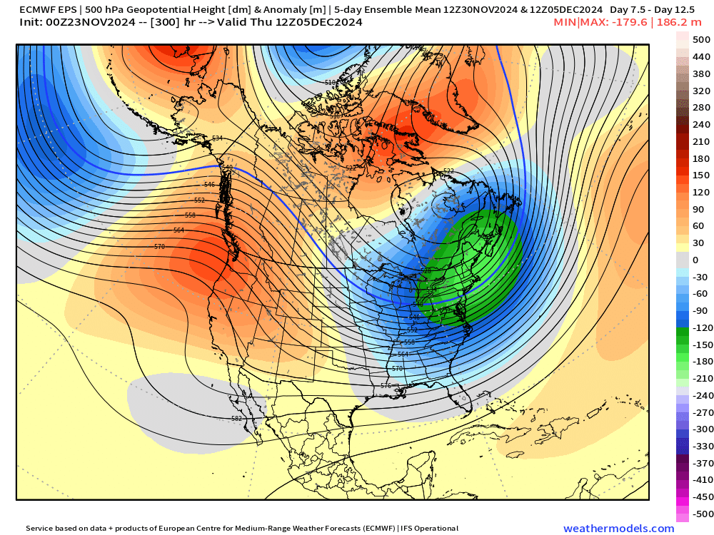
-
Blowvember - and not named for wind potential
ORH_wxman replied to Go Kart Mozart's topic in New England
It is def possible but that’s always a risk when you have arctic cold pushing well south. I’m less worried in early December though when the baroclinic zone is much stronger near the coast and also further north versus, say, mid-January or something. You can’t really predict it very well though since it’s so dependent on individual shortwaves diving into the mean trough and the models can’t see those yet. -
Blowvember - and not named for wind potential
ORH_wxman replied to Go Kart Mozart's topic in New England
18z Euro looks kind of interesting at 144. Antecedent airmass isn’t great but cold enough for wet snow for a chunk of SNE and NY state..esp away from coast. Ideally, we’d like to trend both that TPV push E and SE and the shortwave a bit sharper at the same time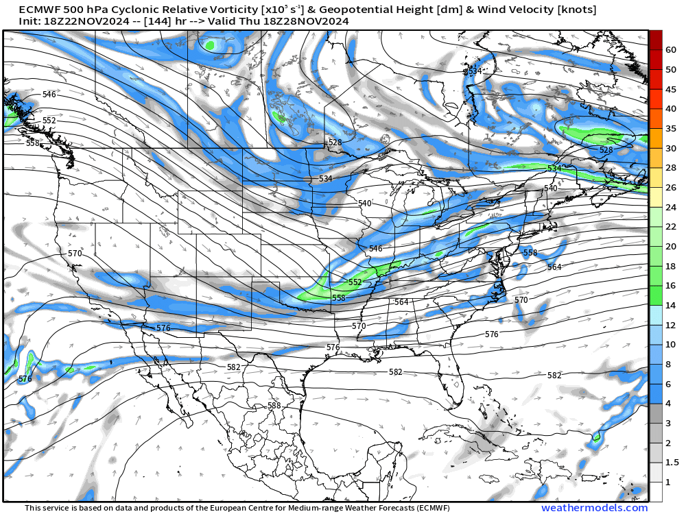
-
Blowvember - and not named for wind potential
ORH_wxman replied to Go Kart Mozart's topic in New England
Early December is going to have a much better antecedent airmass I think for any threats. I think the coast would struggle mightily on these Tday/Friday solutions where the storm gets close enough. Still 6-7 days out though on next week’s threat so too early to be super confident either direction. It was colder this run but also flat…but if you can drive the cold in and then trend the shortwave sharper, then we could end up with a more widespread winter wx solution. -
Blowvember - and not named for wind potential
ORH_wxman replied to Go Kart Mozart's topic in New England
Yeah it should help fill in the huge bare spot in snow cover over Ontario. The extended range almost looks like a cold El Nino pattern with a big Aleutian low and corresponding PNA ridge....couple with a -WPO over the top....we'll see how that actually verifies, but if it's correct, then we're going to be in a cold pattern right through mid-December at minimum....it's not exactly an unstable pattern if it sets up. I'm still skeptical of these amazing N PAC looks on model guidance, but at the very minimum, we're not dealing with overtly hostile variations that we've had over the past couple winters. -
Blowvember - and not named for wind potential
ORH_wxman replied to Go Kart Mozart's topic in New England
GGEM is a pretty significant system Tday night. -
Blowvember - and not named for wind potential
ORH_wxman replied to Go Kart Mozart's topic in New England
Nobody’s getting accumulations in this airmass outside of the highest terrain unless it absolutely rips. Gotta watch it because it’s a bit unstable with that H5 cold pool aloft but you will still need those rates to overcome the BL.


