ORH_wxman
-
Posts
93,099 -
Joined
-
Last visited
Content Type
Profiles
Blogs
Forums
American Weather
Media Demo
Store
Gallery
Everything posted by ORH_wxman
-
Cape and adjacent SE MA gets a grazing blow from the CCB. Prob a moderate event there
-
Oh jeez. Just when we’re trying to let go of the larger solution. This run very well might get the CCB into SE areas.
-
December 2024 - Best look to an early December pattern in many a year!
ORH_wxman replied to FXWX's topic in New England
We develop a defacto west based -NAO though shortly after Xmas, so I wouldn't be shocked to see some blocky/wacky solutions between now and then. Here's today's Euro between D8-11....you can see all those higher heights up in Canada expanding into the NAO domain....its not your classic NAO ridge back building from the Atlantic, but it may still offer some chances for storms provided the colder airmass gets trapped a bit underneath it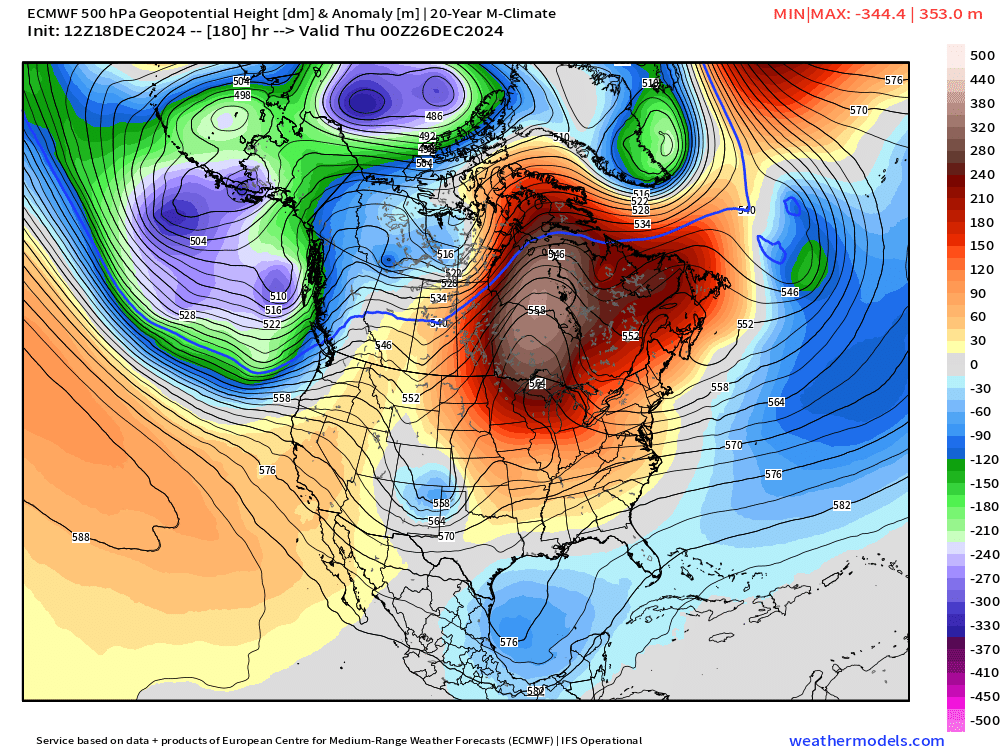
-
December 2024 - Best look to an early December pattern in many a year!
ORH_wxman replied to FXWX's topic in New England
Good luck....I'd prob go a C-1" there....leaning toward C at the moment. -
December 2024 - Best look to an early December pattern in many a year!
ORH_wxman replied to FXWX's topic in New England
Yeah that looks mostly like white rain....maybe if you got above 1200 or 1500 feet it would be better, but that's not what you want to see for accumulations. -
Euro wasn't any help at 12z....it is showing that IVT band from NY moving east during the morning on Saturday though, as some other guidance was showing, so might be a period of light snow for a chunk of SNE from that.
-
December 2024 - Best look to an early December pattern in many a year!
ORH_wxman replied to FXWX's topic in New England
We've been reduced to debating the 200 hour OP GFS run. -
December 2024 - Best look to an early December pattern in many a year!
ORH_wxman replied to FXWX's topic in New England
GEM has the event too...decent snow on Xmas Eve and overnight into Xmas morning. -
Wrong thread for it, but Xmas Eve/Xmas is starting to look more and more interesting.
-
At least we're getting good accurate descriptions of the last few winters in this thread.
-
If this CF sets up with a bit of easterly flow over the top, it might do that from your area to mine....I could see 2-4" happening. The problem is the setup is delicate, so just assume it won't work out until we're closer....but it's a plausible scenario....and yes, a derivative of fraud five, but once in a while they throw you a bone.
-
What a waste of a very healthy shortwave.
-
Yeah I thought it looked better than 6z GFS regardless of sfc low position. I still think this is mostly a tease though...it won't ever get close enough.
-
GFS showing it too now much stronger than before. Shortwave looks better this run too.
-
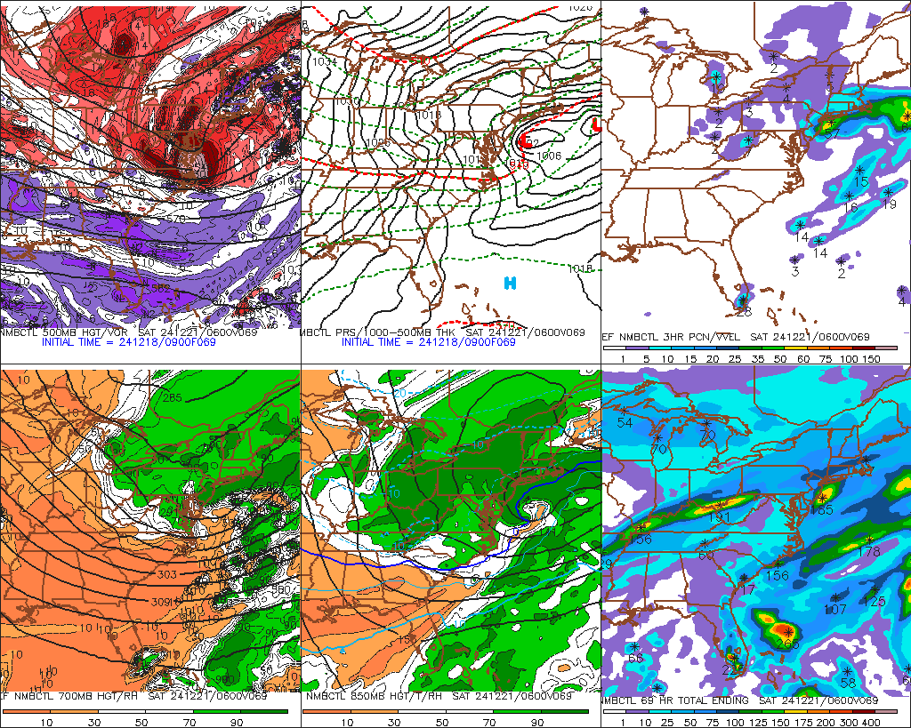
850 temps are like -9C too....so I think we'd have decent low level snow growth if we can get that light easterly flow over the top of the sfc front. This type of setup isn't super common, but we see it occasionally. You can get a surprise 1-3" on the cold side of the front. I remember we had a similar thing happen on 12/15/95 prior to an IVT system that set up later that night....during the day, we had this easterly flow that dropped a couple inches to the west of Boston. Then everyone got a few more inches from the IVT that night as the boundary slide ESE.
-
There's definitely a CF that sets up prior to any coastal approaching the area....RGEM and 3k NAM are kind of similar with it....right over 128 or thereabouts. You can see the onshore flow and then almost northerly or NNE flow on the other side of it with temps 6-8F colder. If things set up correctly, you can get a narrow band of enhanced snow with a few inches on the cold side.... SE MA wants the main CCB to back into their area...if that happened, they would flash to heavy paste.
-
It's that shortwave in the southern stream....so I think it's real. But if it verifies weaker, then we have a chance at something bigger.
-
RGEM was pretty damned close too...actually has decent snowfall in E MA, but not sure I buy it as the main CCB is still a bit east. Almost like a little CF enhanced area from onshore flow.
-
There's always a lot of over-confidence in attribution to failed events on the sub-longwave scale.
-
December 2024 - Best look to an early December pattern in many a year!
ORH_wxman replied to FXWX's topic in New England
Dec '73 had almost 10 inches of QPF at ORH with 0.9 inches of snow....that's about as bad as it gets. It wasn't that cold, but it wasn't a full-on torch either. Just a bit AN....that would usually produce plenty of snow in that. -
Yeah or even if that southern stream would weaken a bit....the NMB guidance actually weakened it enough so that more of the baroclinicty was focused near the main shortwave so it tries to blow up a coastal....still not fully clean, but it would be shovelable snow for most of SNE and prob warning snow for your area. http://www.meteo.psu.edu/ewall/ETAEAST_12z/etaloop.html

-
Yeah its honestly probably costing us double digit snowfall...not an exaggeration. That shortwave is potent....that would be a classic.
-
December 2024 - Best look to an early December pattern in many a year!
ORH_wxman replied to FXWX's topic in New England
I wasn’t. SE NH is unlikely to be a good spot for the upcoming system or any IVT. Best shot at an inch or two is SE MA and then maybe some IVT stuff in CT if you get lucky. I wouldn’t actually count on it though. -
December 2024 - Best look to an early December pattern in many a year!
ORH_wxman replied to FXWX's topic in New England
SE NH is def the pork zone so far relative to climo. Areas like ASH to Derry over to DAW have been screwed pretty bad. They average double digits in December and while there’s still a couple weeks to go, they’ll keep falling behind unless a miracle happens on Friday or that Xmas system delivers. -
December 2024 - Best look to an early December pattern in many a year!
ORH_wxman replied to FXWX's topic in New England
Dec 1968 was pretty brutal. Check out Boston’s F6 data for that month. Very cold month with over 6” of QPF and 5 inches of snow.