ORH_wxman
-
Posts
93,092 -
Joined
-
Last visited
Content Type
Profiles
Blogs
Forums
American Weather
Media Demo
Store
Gallery
Everything posted by ORH_wxman
-
“Cory’s in NYC! Let’s HECS!” Feb. 22-24 Disco
ORH_wxman replied to TheSnowman's topic in New England
The way I know this is a good one is waking up and reviewing all the guidance and saying “I think 15” is the floor here” -
2” of exceptionally dense snow.
-
“Cory’s in NYC! Let’s HECS!” Feb. 22-24 Disco
ORH_wxman replied to TheSnowman's topic in New England
Yeah I remember thinking we were too far west to get the jackpot but then it made it all the way out to ORH -
This is like very thick April sheet drizzle except it’s all garbage flakes. It’s producing a very very dense layer of paste on everything. Temp 31F
-
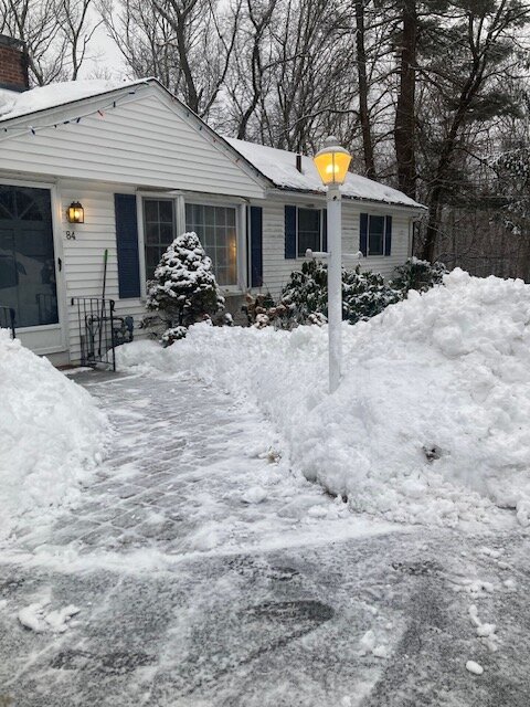
I had already done a pass on the driveway after the first burst that left a little over an inch but I doubt I’ll bother with this current crud unless we redevelop some more and grab a couple inches. I think if it stays below that, we’ll melt it on the pavement tomorrow.
-
Back to all snow here. Crappy flakes though. Almost like it’s low level. But not more pinging or drops.
-
“Cory’s in NYC! Let’s HECS!” Feb. 22-24 Disco
ORH_wxman replied to TheSnowman's topic in New England
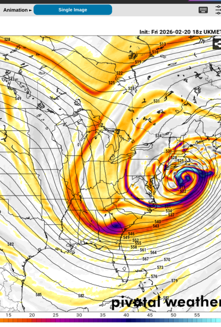
Yeah there's multiple ways to do it, but the most likely is just getting stuck under some bands. It will help if we can advect a MAUL aloft like Tip and I were discussing earlier....as H5 deepens more and more rapidly, that will help. We want it to be deepening very rapidly as it passes just SE of LI and then south of the islands. The other way is if you can get a bit of a stall....even for 4-6 hours as it gets totally stacked. That seems to be happening a bit to our SW making coastal NJ the beneficiary, but these things can change a bit...it's been slowly migrating northeast. -
“Cory’s in NYC! Let’s HECS!” Feb. 22-24 Disco
ORH_wxman replied to TheSnowman's topic in New England
Yeah but when it's email exchanges, it's probably just 3 or 4 emails. Or in Tip's case, he might have finished one. -
“Cory’s in NYC! Let’s HECS!” Feb. 22-24 Disco
ORH_wxman replied to TheSnowman's topic in New England
A little under 2" on the OP run...you're gonna get a HECS there. The only question is how far NW do the HECS numbers get....do they get back to central MA/E CT like 2015 did? Or do the HECS totals stay closer to shore like 2022. -
“Cory’s in NYC! Let’s HECS!” Feb. 22-24 Disco
ORH_wxman replied to TheSnowman's topic in New England
If we don't get a regression on the 00z runs, then I think it's all systems go for most of SNE....it's hard to go low on snow when you have that deep layer easterly inflow aloft of that magnitude. The only thing you rrally worry about at that point is dryslotting but we're not dryslotting with a ULL drilling for oil near ACK. -
“Cory’s in NYC! Let’s HECS!” Feb. 22-24 Disco
ORH_wxman replied to TheSnowman's topic in New England
Getting pretty consistent across guidance with that closed off H5 nuke to the south…the only question left is exactly how close it tracks
-
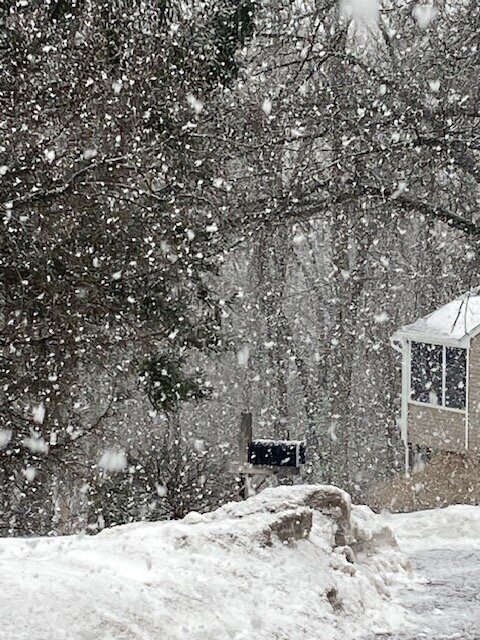
Huge aggies mixed in with these heavier bands.
-
Kitchen sink here now. Mangled flakes, pellets and some ZR thrown in.
-
“Cory’s in NYC! Let’s HECS!” Feb. 22-24 Disco
ORH_wxman replied to TheSnowman's topic in New England
Could be a top 5er on the Cape when you include the wind potential too. If they get 18”+ with hurricane force wind gusts…not too many can match that. Jan ‘05 of course…Feb 1952…Jan 2015…then maybe Feb ‘87. Not sure ‘87 and ‘15 had the winds quite as strong but the snow was epic and it’s not like it was a gentle breeze either. -
Getting a few pellets now.
-
We still haven’t had any mixing here. But snow growth is mostly awful. Very dense pasty snow. Good refresher at least.
-
“Cory’s in NYC! Let’s HECS!” Feb. 22-24 Disco
ORH_wxman replied to TheSnowman's topic in New England
Yep, Reggie is a pretty pedestrian low end warning event for most...except the Cape and maybe south shore. -
Light snow here...been cruddy growth since that 1 hour burst moved through. But no pellets yet. They seem to have trouble getting north of MA/RI border.
-
“Cory’s in NYC! Let’s HECS!” Feb. 22-24 Disco
ORH_wxman replied to TheSnowman's topic in New England
Prob some terrain enhancement when 850 is ENE at 80 knots and 925 is out of NE at 60+ knots -
“Cory’s in NYC! Let’s HECS!” Feb. 22-24 Disco
ORH_wxman replied to TheSnowman's topic in New England
-
LR is showing some sneaky ridging over pole area becoming more amplified which is stretching the PV in Canada a little and pressing it south....we could have another shot of arctic cold, though obviously not as stinging as we get in January or early Feb. Also probably additional snow chances. Definite gradient pattern though...so cutters are a risk too.
-
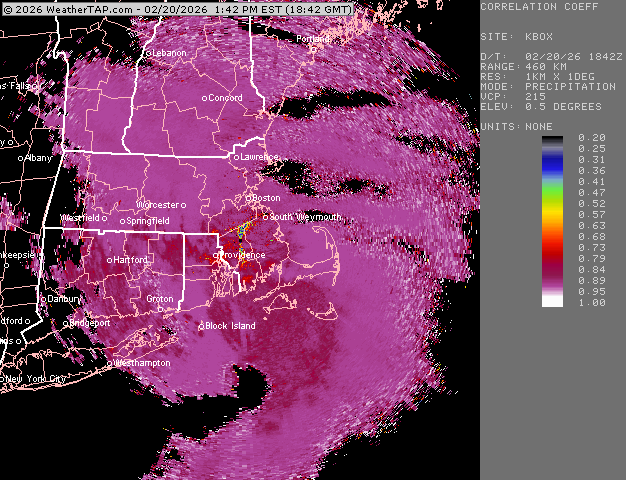
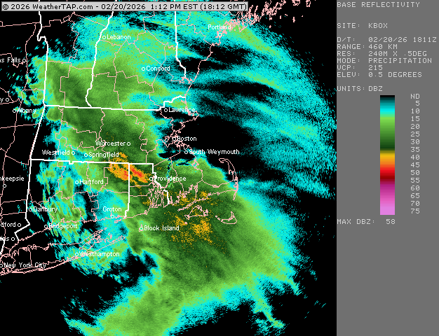
Still absolutely pounding here. About an inch so far. CC shows sleet line sort of hanging near MA/RI border at the moment
-
Poundage
-
Now we're pounding as these better echoes move in.
-
Steady snow has commence here. Light but steady. Heavier echoes about to move in, so maybe we can grab a quick 1-2"....not expecting much though.