baltosquid
-
Posts
1,236 -
Joined
-
Last visited
Content Type
Profiles
Blogs
Forums
American Weather
Media Demo
Store
Gallery
Everything posted by baltosquid
-
slowed it
-
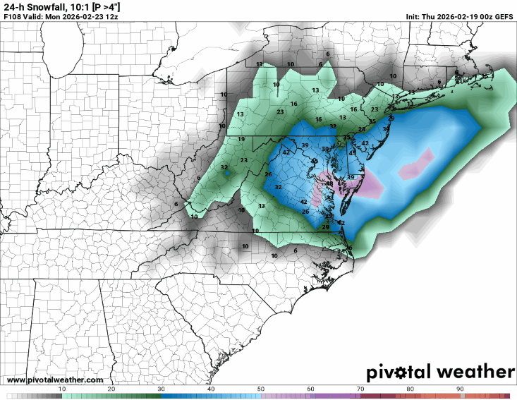
Big jump in probability for >4" 10:1. We're shedding bust members. Edit: slower
-
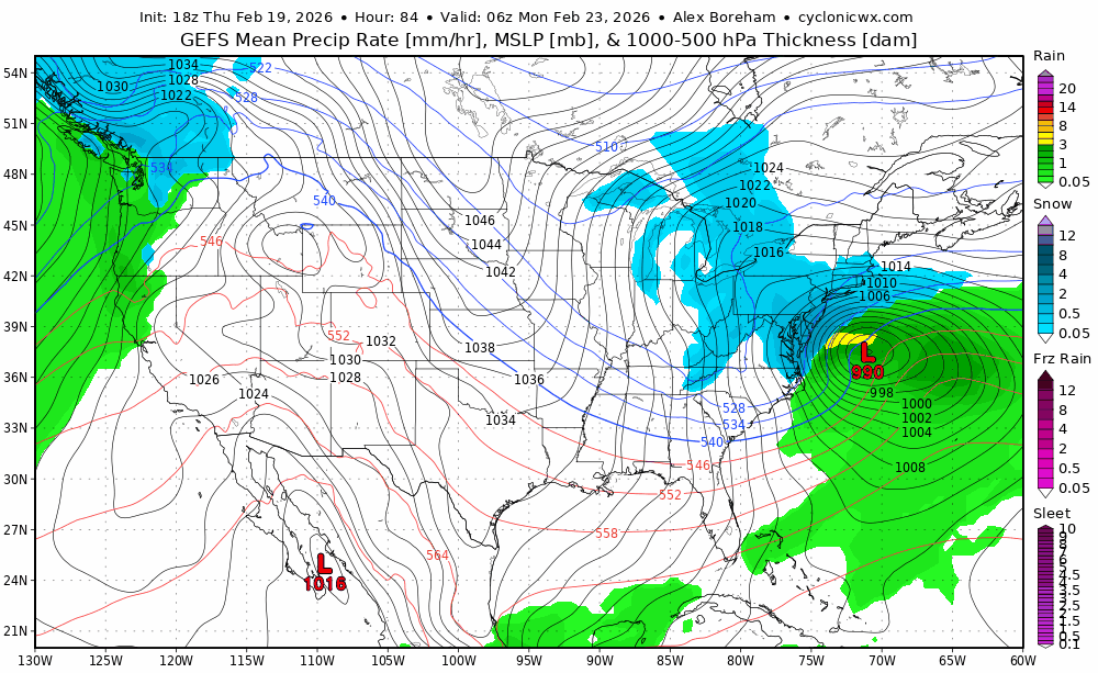
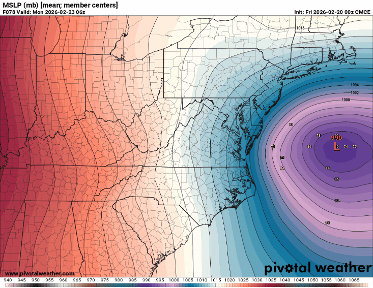
UKMET not much different than 12z, maybe norther, rather than west/east changes. Low center is a tick W/NW and 986->981mb at hr57 but the precip isn't doing it for us.
-
in case the classic rhyme is a jinx, I'll just say the trend is our amigo
-
Keep it coming
-
Give the h5 another nudge like that at 00z and I think we won't have to worry about the surface presentation responding. On to the Ukie.
-
Wait til it captures... then I think we know the word
-
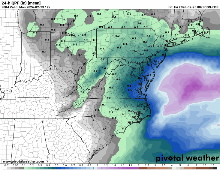
ICON ensembles bringing precip NW.
-
We got the one Canadian shortwave to trend better and play nice, now we need the other one to back off. This had more potential than the improvements we're already seeing imo with the heights ahead being that much better.
-
It has room to amplify but it isn't tilting any faster than 12z, probably because of the trailing wave and it might be a little messy itself. But no change to tilt and better heights is still a good change on balance, of course.
-
Yeah it is a hair more negative at 42. And the ridging is so clearly better. Don't even have to look at the surface to see it's getting development going much further west... but I did peek at the surface earlier and there were showers/snow in TN/KY.
-
I actually think it's pretty similar or maybe slightly more negative but maybe my eyes are broken... it's bigger though. But only to the west... way less broad up front and lots more ridging, which should be good. I hope.
-
hmmmmmmm

-
Also, the base of the trough is more north, not as deep, but hasn't consolidated fully yet. So we'll see what happens in a few frames.
-
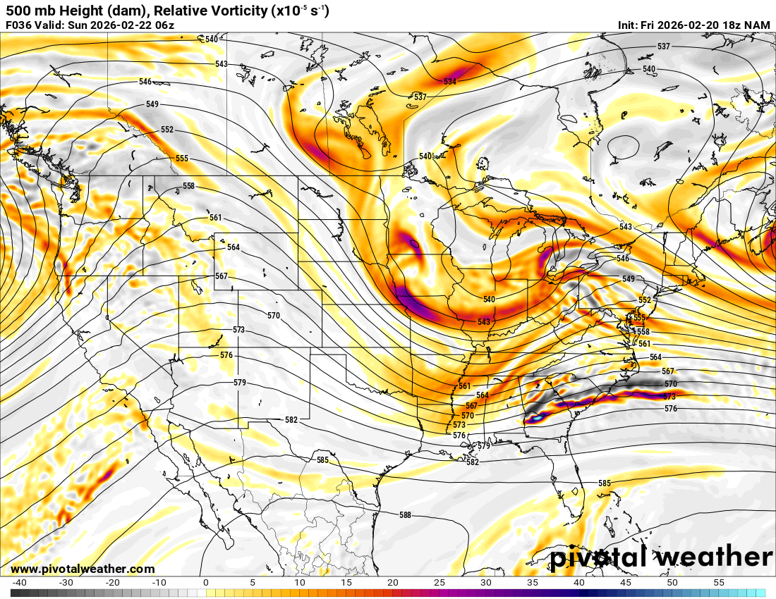
NAM, At 30, heights ahead of the wave are obviously higher, and steeper. It looks like it has more room to amplify. It might be a little messier with the pieces though. Hopefully it can turn the corner.
-
Only maybe notable changes on the NAM through 18 is the higher heights in the west, and the Canadian shortwave is coming more south. Otherwise, very similar, maybe the trough is a hair narrower or perhaps west. Can't draw any conclusions.
-
Sorry if GEPS was already posted but damn that's a good jog west!
-

Feb 22nd/23rd "There's no way..." Storm Thread
baltosquid replied to Maestrobjwa's topic in Mid Atlantic
Wall to wall improvements at h5 for 12z. Do we get the extra nudge or two that makes the models more GFS like? Unlikely, but to be fair, even getting to this point was unlikely. -
Feb 22nd/23rd "There's no way..." Storm Thread
baltosquid replied to Maestrobjwa's topic in Mid Atlantic
Hopefully it's too aggressive with temps. I recall it wasn't the greatest with the snowcrete storm? Also maybe another jump like that and the rates pull through. -
Feb 22nd/23rd "There's no way..." Storm Thread
baltosquid replied to Maestrobjwa's topic in Mid Atlantic
Temps on the UKMET are just so bad lol. Anyway the H5 is better and coastal comes further west. Not GFS at this point. But a step. -
Feb 22nd/23rd "There's no way..." Storm Thread
baltosquid replied to Maestrobjwa's topic in Mid Atlantic
Looks like the peak probs of >1" QPF have dropped but they are moving more inland. Probably less clown 3 footers lol. Edit: switched to a later hr.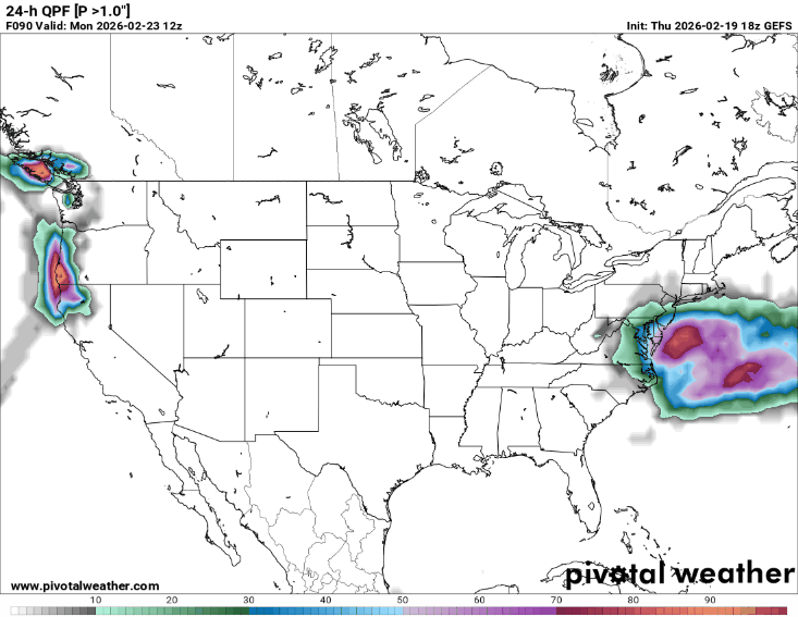
-
Feb 22nd/23rd "There's no way..." Storm Thread
baltosquid replied to Maestrobjwa's topic in Mid Atlantic
12z GEFS at 60 ticks west. Edit: Though it may be a tick drier, we'll see. Not anything major. -
Feb 22nd/23rd "There's no way..." Storm Thread
baltosquid replied to Maestrobjwa's topic in Mid Atlantic
No surprise with the CMC as it's basically the RGEM. It is trying so hard to bring in the low but it's just got too much pulling it out. Give me another shift like that at 18z on the RGEM and we'll see. -
Feb 22nd/23rd "There's no way..." Storm Thread
baltosquid replied to Maestrobjwa's topic in Mid Atlantic
Honestly... the changes in the Ohio Valley are a little eyebrow raising. Since yesterday's 12z, the GFS had been going with a sort of three piece look (which other models had believed in) where the main wave is actually two pieces close together trying to phase, followed by a separate one further NW. This run mostly consolidates the main wave into one, and the trailer is still up NW. As long as that trailer gets close enough to bring the storm up, rather than just hinder the tilt, I don't see a reversal of the ticks NE as too crazy... -
Feb 22nd/23rd "There's no way..." Storm Thread
baltosquid replied to Maestrobjwa's topic in Mid Atlantic
ICON-EPS ticked west with member lows.