

Torch Tiger
-
Posts
13,471 -
Joined
-
Last visited
Content Type
Profiles
Blogs
Forums
American Weather
Media Demo
Store
Gallery
Everything posted by Torch Tiger
-
This is epic! Year without a summer they said
-
.. LFG.
-
It's rough out there, especially 12-3pm.. but lots of able-bodied people also complaining/whining. same ones who probably work indoors most of the day and shut-in at home
-
dozens
-
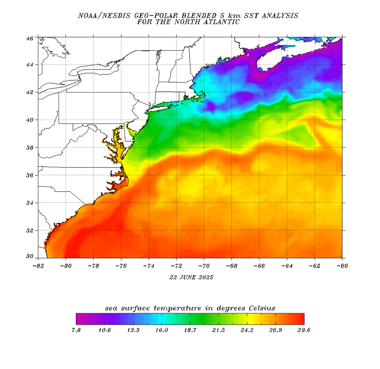
Impressive to see Cape Cod and even MVY mostly low 80's for highs. Surrounded by 50's to low 60F's F (generally) ocean chill. It'll be fun to watch SST's respond
-
This is a SC heater day but nothing crazy. Agree
-
This is up there with the gulf coast Houston to Lake Charles heat all day. I know it when I feel it. In addition, the very long daylight hanging on so we extra enjoy that last swim or BBQ on grill
-
sitting out for a half-hour in carhartts and two layers/flannel, whew! breathaking in the best way possible! Going back out, so perfect outside
-
73 inside and after an hour of shut-in, I'm freezing cold.
-
I notice car thermo will be higher with engine heat contamination. Like that 109 earlier ...lol...I was idling for 5 minutes with no breeze. If you are cruising on I93 it should not be wildly high, maybe a few degrees.
-
Stein on it
-
Worked in and out of the heat from 5:30am to 2:30pm. Sensational day, everyone outside enjoying the weather. Another reason the heat is great; can fast for 18/24 hrs., and just drink water without being hungry!
-
Yes! Yes!!!
-
98 on car therm in Arlington lol
-
Gooooood morning! Beautiful day in Arlington MA!
-
So dumb
-
good eye
-
18z gfs gone wild for July 4th-5th.
-
Torch!
-
hope that HI hits 120!!
-
Gorgeous evening sitting on the patio, listening to the Sox lose!
-
That man-made or natural?
-
Yeah, furnaced tomorrow after the early morning crap/clouds. Hopefully we recover fully
-
Yeah much more notably dry here, 50's. Sucks


