

Ruin
-
Posts
918 -
Joined
-
Last visited
Content Type
Profiles
Blogs
Forums
American Weather
Media Demo
Store
Gallery
Posts posted by Ruin
-
-
Went from 33 to 36um ok precipitation falling thought temps would go down
-
Is it me or are the radar returns way more juicy the models suggested? I heard no talk of heavy rain downpours thunderstorm etc a bunch of deep greens yellows just down to out south
-
Powers out
-
31 now pretty heavy mix/sleet?
-
Im bouncing between 27-28
-
just thought if we do get above freezing we are not going to be dry slotted that fetch of yellow and dark greens off the ocean could cause some flooding ground still rock hard frozen then snow and ice on top of the snow no where for run off the go from dirty grassy areas
-
3 minutes ago, Voyager said:
If Accuweather's future radar is to be believed, I'm going to see some HEAVY sleet here once it flips. There's a lot of yellow and orange colors in the radar presentation aimed right at eastern PA.
I posted about this a bit ago a good fetch off the cold ocean right back into south central PA
-
Back down to 25 and snow
-
Just now, KPITSnow said:
I certainly don't blame mets, and certainly 2-3 days out I know things can change, but we are going from a forecast of 12 inches here to possibly not even meeting warning criteria.
yes but most of the public dont have the time nor the interest to plot models and track storms
-
 3
3
-
-
2 minutes ago, KPITSnow said:
This was another major model fail, at least out our way. We went from deform band last night here to having Cleveland, who wasn't even warned till a couple hour ago, getting 20 inches potentially.
this is why the public miss trusts weather forecasts. look what happen to i95 up till a day or 2 it wasnt suppose to be so bad. then bam hell people stuck in snow banks going hungry no one helping them no plowing before hand.
-
26 and mix
-
I questioned if the models didnt get storm right cause of the odd track they gave it. makes me wonder if its no longer following the track or its moving slower. edit im talking about how much cold air is still sticking around
-
11 minutes ago, pasnownut said:
every hour more is a win for many

very true
-
still mod snow here big flakes 23 first inch upward in temps in about 7 hours
-
1 minute ago, medmax said:
Changeover has pushed an hour on the hourly forecast with TWC FWIWmy temps have stayed steady im talking local forecast abc27 said change over to rain around 930. its 8:08 I dont see it happening till later if it does go to rain before we get dry slotted.
-
Just now, medmax said:
Snow/Sleet and up to 23F in Hershey/Hummelstown area (3 miles up the Swatty from MDT)
oh its gonna be a nasty ice storm then for the next few hours
-
Im still at 22 digital says 21.8 I cant see us changing over to rain tonight at this rate the way they said. rain by 930/10 abc 27
-
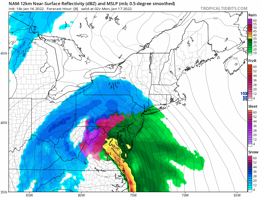
Just now, Voyager said:
The banner says MLK Day, so I'm assuming today. I do believe they're going to bust badly. It looks like they have the Selinsgrove/Sunbury area in the 12-24 range and that just isn't going to happen.
yeah we always have busts highs and lows but none of the models saw this amount of cold sticking around
-
6 minutes ago, mahantango#1 said:
About 40 min ago.
nice so the map says 4-8 and right at the line 8-12Now I have to ask is this for tonight's event or next weekend sorry dont wanna be confused. whats the source from this post twitter?
-
1 minute ago, mahantango#1 said:
Good Ole S&S forecast!
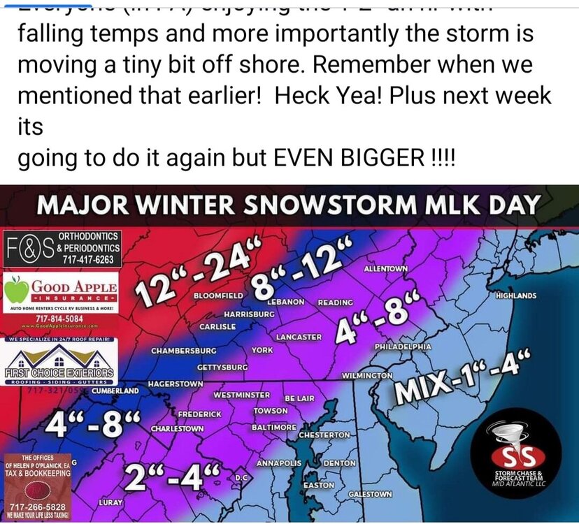
um since half the page is cut off is this a older post from earlier this week? or is it new?
-
1
-
-
1 minute ago, mahantango#1 said:
WHTM 27 just said another 2-3 hrs of snow before changeover.
thats what they said for the original forecast 9:30 10:30 I feel its gonna bust tho maybe go to 1am i hope temps just are staying frosty
-
1
-
-
Steady to heavy wind driven snow at times temp bounding down to 20 back up to 22. was forecasted to be at 29 at this point tonight
-
has any been bumped up from a wwa to a wsw?
-
mod snow temp down to 19
-
1
-

Central PA - Winter 2021/2022
in Upstate New York/Pennsylvania
Posted
Welp its dead in here heh. My temp is now up to 38 temps were fore cast to go down. front passed 2 ish hours ago this is kind of sad lol.