

Ruin
-
Posts
1,519 -
Joined
-
Last visited
Content Type
Profiles
Blogs
Forums
American Weather
Media Demo
Store
Gallery
Posts posted by Ruin
-
-
10 hours ago, SnowenOutThere said:
In the nicest way this is the mid atl forum, so I’m sure south central PA has a different weather experience the past few months. For 90% of us we have not had such luck.
I drive a lot between both jobs and I like to go on trips just day ones when im off just to drive. I havent seen 1 area in PA that was dry as in brow grass or not as green grass except philly. Ive been all over the state too.
-
On 5/26/2026 at 11:43 PM, JenkinsJinkies said:
Why do I get the feeling that this was yet another one off that tricked us into thinking it’s the start of a sustained wet pattern…
Then again those dry maps stop mid next week and it’s just a relax before a reload.
I keep hearing its dry and we are in a drought but wee have been very rainy last 3 months maybe a dry week every so often. I have water in my back yard 1 to 2 days after it rains anywhere over .25 that means that the water table is high due to it being rainy. I dont even live at the bottom of a hill I live on top of one in fact. I travel every week north east south in the state only place I see even a hint of brown grass was near phily. even during that crazy hot weather we had for a few days this month and earlier this spring didnt see it.
-
14 hours ago, WmsptWx said:
Yes, I'm sure you know more than subject matter experts...
when we have weeks of wet weather and even have water pooling on my grass in my back yard for a day or 2 after the rain. esp when the map hardly changes at all or stays the same.
-
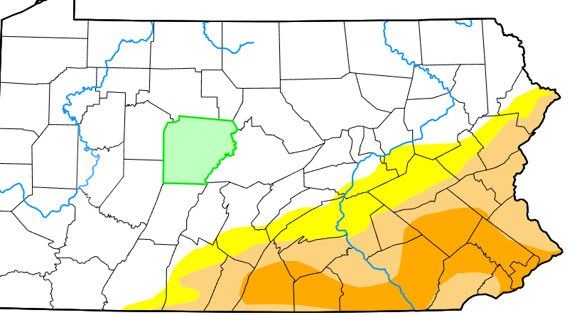
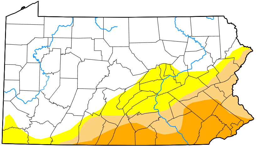
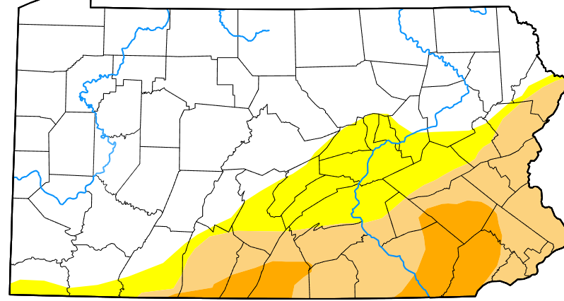
Again this map is no way near accurate im sorry its changed a bit but no way we should still be in the orange color
-
this is from 6 hours ago but how on earth does that part of lancaster county have no damn rain? this is how inaccurate weather reporting is imo.
-
15 hours ago, Blizzard of 93 said:
It’s ridiculous that I need to have heat on in the house this Memorial Day weekend, but here we are…
yep they dont talk about how cold it is and hype it up as much they do when its 95 in may lol
-
had .30 yesterday last night the collector fell over so no reading.
-
On 5/15/2026 at 8:44 AM, Jns2183 said:
Haha, it might be because people are still below the 40th percentile for ytd rainfall. Honestly unless we get area wide coverage of 25" from now till end of August I'd expect this map will be there the entire summer. Add in the fact that many have not had an above normal season in 3-4 years I'd be more worried if the map showed nothing.
Sent from my SM-S731U using Tapatalk
when I had the landscaping crew putting in the trees they did a test and the moisture in the ground was like 46%-48%
-
15 hours ago, Jns2183 said:
Haha, it might be because people are still below the 40th percentile for ytd rainfall. Honestly unless we get area wide coverage of 25" from now till end of August I'd expect this map will be there the entire summer. Add in the fact that many have not had an above normal season in 3-4 years I'd be more worried if the map showed nothing.
Sent from my SM-S731U using Tapatalk
we had above precip the last few months and this map hasnt changed. winter was a tad dry but I feel like they just keep releasing the same map cause they dont want to make a new one cause not many people even care about it. no way we are even close to any of this drought color.
-
Yep its way off it hasnt really been updated in like 2 months at least. I got close to 1.00 of rain in the last week that would put us even for the year.
-
another week we had a good amount of rain but still this map hasnt changed
-
7 hours ago, WmsptWx said:
It has barely rained in those areas.
I live in the orange area and we have had rain the last month like 2-3 days a week. while some of it was showers and was only .20 we had other rain events 1.24 1.01 .86 .66.
May 5, 2026, Harrisburg has experienced rainfall total of 11.56 inches, which is a deficit (departure) of -1.39 inches compared to the 13.95 inches average typically seen by this date. we are only down 1.39 This update doesnt even include the thge last round of rain where we picked up about .40 so that means we are about a 1 inch down. no way we should be in the orange color of drought
-
still the same bs map they havent updated it tho they claim they have
-
-
On 5/4/2026 at 2:44 AM, Jns2183 said:
It's a lot more than rain goes into that. You have to look at absorption vs run off vs evapotranspiration. We have baked all April. I only got about 55% of normal preceiptitation. Go look at the PEMN sites on pa climate website. They have soil moisture at 3-5 different depths. That really tells the story. This super El nino building is not good either
Sent from my SM-S731U using Tapatalk
I did some stuff outback ground is pretty green and wet dug down a bit to plant a new tree in the back yard and moisture content was very high. the landscaping crew told me only to water it a little after planting since the ground lvl water table is high. So yeah we had a short period in april where we got way hotter then normal. but last 2 weeks aside from this tuesday we have been very cool to cold over night. 3 times last week I had frost on my car at 530-6am getting out of work.
-
 1
1
-
-
26 minutes ago, Voyager said:
I didn't know it was going to rain all night. Picked up another .17" from this little event.
last 3 days Ive picked up 1.21
-
No way this is accurate we have been the same color since late jan we have had so much rain for a month plus.
-
Forecast high today 83 still 55 lol
-
this is fake spring atm temps to go back down but its nice to have some warm weather. bee's were out in force today but no flowers just yet blooming for them to gather any honey.
-
5 hours ago, Blizzard of 93 said:
Yes, I would sign for the 12z AI.
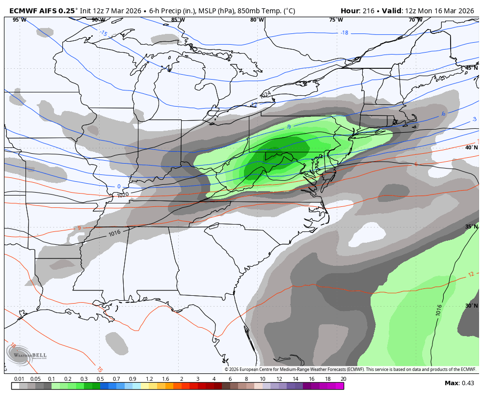
A nice & simple moderate wave with a good non complicated slug of precip this run.

in time they will all loose it then the ghost of the storm will show for a run or 2 then vanish its how it works
-
9 hours ago, Itstrainingtime said:
Endless drought talk? What?
I haven't said a word in months. Literally.
I have seen a ton of talk about this all the time if we are just a inch down they talk about this on the local news weather. infact last spring was very wet we were up like 4.00 inches for the year it didnt rain for a week and we were down like -1 inch for the year? they honestly havent relaly stopped talking about it even during the cold snap
-
12 hours ago, pasnownut said:
Yeah this weeks "warmup" so far has been an epic fail. Just looked and NWS has me in upper 40's today and tomorrow. i memory serves a week ago I thought I'd be in the 60's and some said ticklin 70. Regardless this is typical spring weather and while I HATE mud....we need the rain and looks like plenty of chances to suppress the spring wildfire worries.
Why i always bitch they can't get most things right jist 3 days or so out
-
2 hours ago, Blizzard of 93 said:
More on the Winter comeback potential from @bncho in the Mid Atlantic thread…
Euro AI has back to back hits.
Ill bet a chick fil a meal this will be cut in half in a few days then turns into a apps runner
-
7 hours ago, ChescoWx said:
This Winter Season (December thru February) of 2025-26 here in the philly burbs of Chester County PA finished as the 14th coldest winter across 133 winter seasons since 1893-94. Below are the top 20 coldest winters. Of note 4 of the coldest have occurred since Y2K.
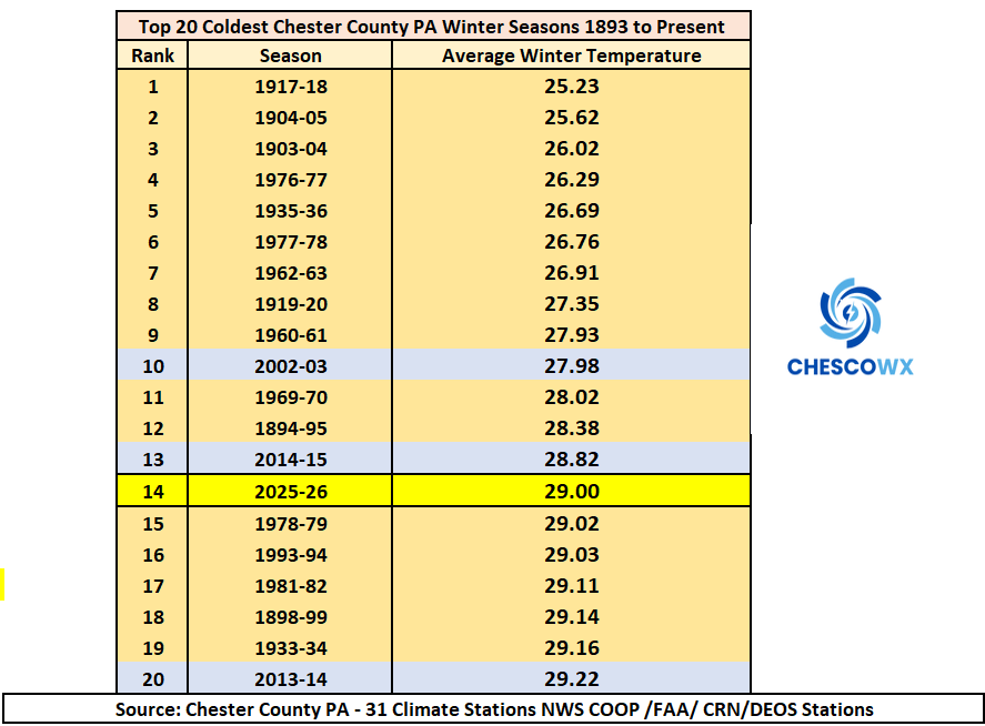
I kind of feel it was way colder then this
-
1
-


Central PA Spring 2026 Discussion/Obs Thread
in Upstate New York/Pennsylvania
Posted
Im not saying I know more but I know what I see on news reports when they claim we only got .75 of rain but the collector at my house which is near the reporting station they use has 1.33 inches. I know because I have seen how rainy the last few months have been. sure not every rain even is a downpour some days its just light rain all day but that adds up. Wed we just had .29 inches of rain and abc27 said only a trace? I had to cut my grass like 5 times in the last month its growing like crazy cause all the rain we have had. the th river has been hovering around 5-6.4 feet for most of the spring thats pretty healthy water lvl considering they say we are in a drought. The average water level (or gage height) of the Susquehanna River in Harrisburg during the spring typically ranges from 3.5 to 7 feet.so this is a average water depth.
I also go fishing a ton with a group of friends streams and creeks water lvls are pretty healthy for this time of year. ive see way lower water levels in the past with less of a drought. so this is why I quesiton. I see what they say but I use my eyes to see as well and frankly its not mathing.