

Ruin
-
Posts
918 -
Joined
-
Last visited
Content Type
Profiles
Blogs
Forums
American Weather
Media Demo
Store
Gallery
Posts posted by Ruin
-
-
9 minutes ago, winter_warlock said:
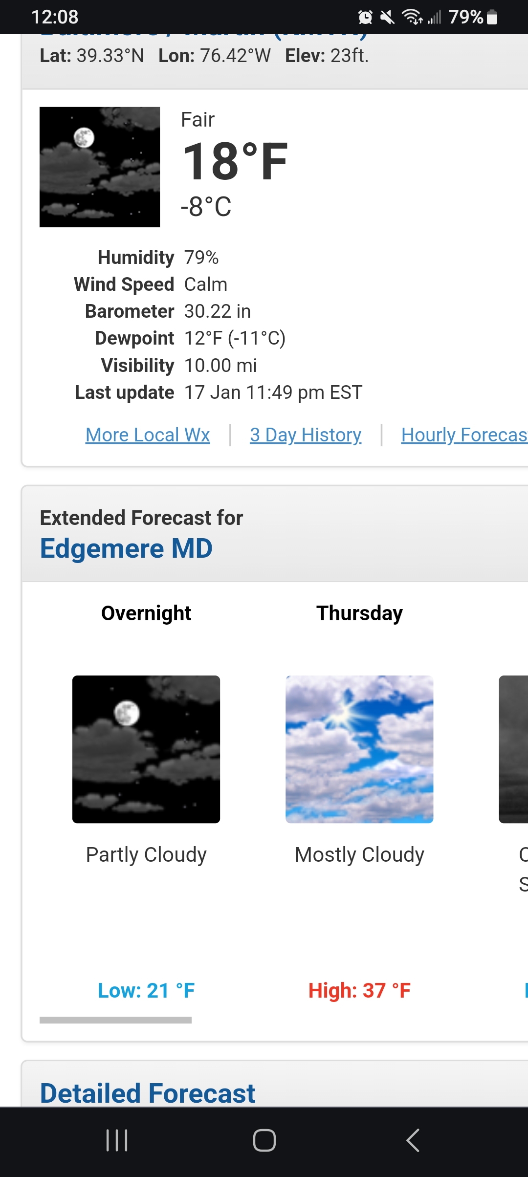
This is funny. Notice the NWS forecasted low of 21 tonight yet my temperature is already below that at 18 lol.
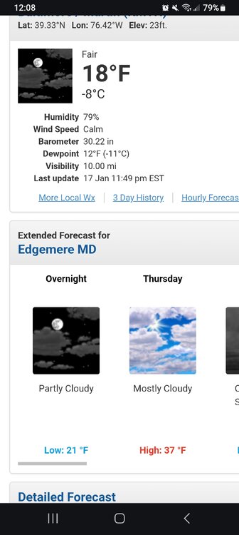
this happens in my area very often. then you watch the weather news and they give you a low thats a few degrees higher then what you got.
-
Posting these pics for a big snow luck charm the big snowstorm in 2011


-
 3
3
-
-
18 minutes ago, Bubbler86 said:
I thought you were near MDT. I just did a point and click and it says high of 29 which is in line with most models....maybe a degree or two low.

thats where my dad lives. I visit him often but im about 20 mins north.
-
1
-
-
Snow during the morning will give way to lingering snow showers during the early afternoon. Temps nearly steady in the low to mid 20's. Winds N at 5 to 10 mph. Chance of snow 80%. Snow accumulating 1 to 3 inches. So my forecast for friday they only have snow in the morning giving way to snow showers in the early afternoon. still going for a 1-3 inch ball park but temps either are an error or this storm brings its own cold and with the clouds for thursday it just cant get up to the 30s
-
Ty for the replies on the namming
-
1
-
-
I forget does getting named mean the rug gets pulled out from under us less snow. Or does it mean over performing
-
14 minutes ago, Bubbler86 said:
Just one model but 25 seems dubious at this point.

Well that's what my local forcast shows
-
48 minutes ago, Bubbler86 said:
It is not going to be that cold down our way per progs. Near 28-32.
for me is 25 for the high
-
Still odd with cold temperatures we can't score a higher snow rate
-
Be careful rapid freeze tonight temps to go to low teens
-
 1
1
-
-
Not sure where the radar that is out is located but since 6am the lightest is snow ever maybe .10 since only cause it's still so cold. Forecast temp today was 34 surprised me. Temp ATM 27
-
If it were to fill back in what time would it be? on model runs I saw non dry slotting at this time I heard between 4-7 would be the best time to pick up amounts.
-
1
-
-
sadly no back filling at all back edge got here way faster then many thought.
-
7 minutes ago, eddygeeme said:
LP is still onshore down in SC/NC West of Wilmington. Back filling would come from that as it passes by. What you see is just a dry slot or a lull.
I know but so many times it doesnt do what it should imo. it just dry slots us to death and we go from a promising over performing storm. to the local mets pounding chests saying they were right. id say its 50 50 on times it back fills precip vs it doesnt.
-
29 minutes ago, Stormchaserchuck1 said:
Moderate snow here for the last 15 minutes, bigger flakes. 4" total. It looks like radar is backbuilding still! Both the 6z Hrr and RAP had no more than 1/2" to southern PA..
edit: tiny, nice flakes again. lots of them! The coastal must be developing.
looks like the back end is moving in faster then forecasted? unless we get some back end filling in thought it was supposed to go until 10am
-
maybe 2 inchs so far

-
1
-
-
snow rates went from no snow starting my drive home. too moderate by the time I got home. accidents all over but highways had almost no snow cover. most likely just dummies speeding
-
With how broken up the precipitation field is I guess We get about two inches and I'll be happy with that. At the moment snow stop and what snow did lay is now melting
-
 1
1
-
-
1 hour ago, Blizzard of 93 said:
ABC -27 is really going low with 1 to 3 & said most should end up with 1 or 2….but he’s been “watching it closely”!
They always low ball then claim they are right lol
-
Very confused a few Said most likely 4 to 5 start time on here and still nothing. Now we did have a line go through around 2 laid down such a light dusting but that's it
-
Radar broken and dry south west
-
start time looking past 4pm?
-
finally got power back 4 homes in my town had none all night. im so glad it was single digits last night. good luck with the snow all. hope to get a hot shower before work
-
Only 6 homes without power nmfkr last for hours. Site says ain't very reatore till 11pm 1/16

Central PA Winter 23/24
in Upstate New York/Pennsylvania
Posted
im down to 11 forecast was for 14