

Ruin
-
Posts
918 -
Joined
-
Last visited
Content Type
Profiles
Blogs
Forums
American Weather
Media Demo
Store
Gallery
Posts posted by Ruin
-
-
woot snowing pretty good
-
 1
1
-
-
1 minute ago, jayyy said:
NE MD into extreme SEPA and interior NJ potentially. Let’s see how it plays out
any hope for south central PA harrisburg area Lancaster? Id like another inch or 3 lol
-
1 minute ago, jayyy said:
Clear signs that the 500mb low is rapidly closing off. Should occur around NoVA w/ current trends. The 500mb low is the KEY factor in capturing the storm and pulling the precip shield west. Unfortunately, this occurs too late for Baltimore proper

what areas north of balti could benefit from this
-
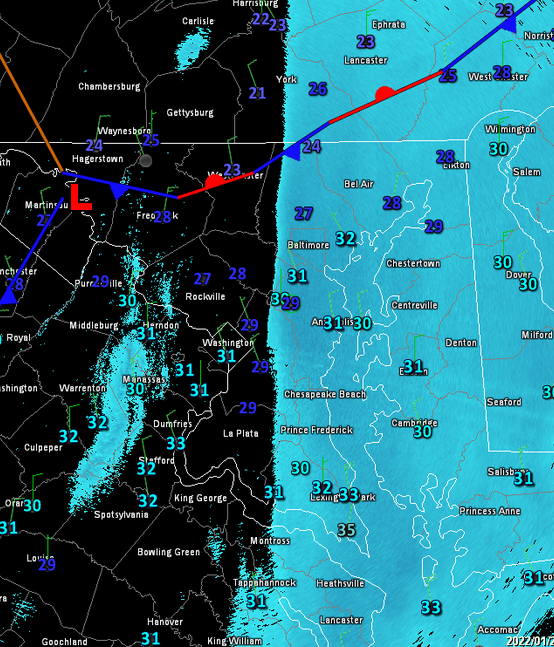
also a question on this pic showing the front still alive and didnt wash out like forecasted? will this benefit us if its stalled like this?
-
8 minutes ago, KAOS said:
Don't worry it is back building...
I love back building but so many of us on the edge. id rather be in the snow as it back builds if you get what im saying. normally after it back builds it normally goes up in smoke sooner then id like.
-
1
-
-
snowing again in harrisburg area very lightly but bigger flakes looking out side every thing looks like Diamonds
-
8 minutes ago, losetoa6 said:
Best pixie rates currently of the day

Who needs radar
same in southern PA no snow on radar current conditions say cloudy but a light snow starting to coat roads been coated side walks and grass as soon as sun went down
-
1
-
-
55 minutes ago, canderson said:
No this was never our storm.
Not our big storm no but plenty of model runs days ago showed 6 inchs
-
16 minutes ago, Itstrainingtime said:
CTP just dropped my forecast from 1-3" to "an inch is possible."
Like always lol
-
3 minutes ago, CAPE said:
Pretty much all guidance has shifted the coastal low more westward to some degree. The NAM and GFS have an impressive 700 mb low moving right along the coast. Coastal NJ gets hammered on those runs. Coastal DE and MD would also get in on the impressive snow rates just to the left of that h7 vort max, and with the advertised wind, no surprise to see the Blizzard warning.
right along the coast maybe we can see some snows then?
-
going into work for ot tomorrow I may leave early since its Kind of on a summit and tricky hills
-
13 minutes ago, Roger Smith said:
That is a superstorm whether it happens or not, it's certainly the way things have been trending all day and night, but confidence in it remains sketchy until at least one of the other models duplicates it.
Much further west at initiation, and deepens continuously from east of Hatteras to near Nantucket where it reaches 957 mb with a very tight circulation.
Verbatim would probably give much of the Delmarva 15-25 inches, most of NJ 20-30 inches, NYC 18-24, LI 20-30 with monster drifts, CT 20-35 and parts of MA 30-40.
Puts BAL in the maybe zone for marginal blizzard and 5-8 inches, DC maybe 2-4? But it's all speculation until we see the goods.
I understand about having a tight storm and tight circulation. but the same time its a huge storm and the moisture field early on like 6 days ago was huge even the sub 960 L. Ive seen so many storms that have been sub 960 all these mets were shocked by it and were saying no way thats a cat 2 hurricane etc. I chuckled cause in the last 20 years Ive seen so many.
-
12 minutes ago, jayyy said:
At least what were rooting for — a slightly further west track than what’s being modeled - is a fairly common occurrence. Better digging out west, a slightly earlier phase, the trough a bit sharper, etc. in order to keep the storm relatively close to the coast despite a lack of blocking. The problem is the setup. The lack of any semblance of blocking is the thing leaving me pretty skeptical, but I guess we’ll see if there’s any surprises in store come tonight.
I was shocked on a few model runs it was at the bench mark and southern PA north MD VA hardly got anything or nothing. I cant remember the last time a bench mark snow gave so many around i95 nothing esp north and west. tho most of the time we have low going north from the south then transferring off the coast.
-
wouldnt it be nice out of all the times the models took away our storms that this time we get a storm back from the jaws of defeat
") just 50 miles more west and so many of us will be happy with our few inchs
just 50 miles more west and so many of us will be happy with our few inchs
-
1
-
-
Honestly would be nice for all the storms models took away if this trended another 100 miles west or so and gave us close to 4 to 6 inch's
-
-
1 minute ago, mahantango#1 said:
Wouldn't be awesome if we all wakeup tomorrow and have Winter Storm Watches for eastern Pa? But I'm dreaming again.
jinx I said Maybe ill wake up to a diff forecast lol
-
I thought the one over night model was still out to the east? from the things I read at least I hope to wake up to a diff forecast lol
-
23 minutes ago, Festus said:
Priceless AFD from Mount Holly. So you want to be an NWS forecaster...uh, well,
SHORT TERM /FRIDAY THROUGH SATURDAY NIGHT/...
...Major winter storm possible for much of the region Friday
night and Saturday...

It has been a live-or-die-by-every-model-timestep sort of night here
at the office. And what the models give, they also take away, which
basically describes the model variability we have seen the past
couple of days with the potential winter storm for our region Friday
night and Saturday. The 00z suite has made a notable consensus shift
westward with the low tracking just off the coast, but the high
volatility/variability remains. The 00z GFS is a far-east outlier
solution and basically brings little snow to the CWA for the whole
event. Meanwhile, the 00z NAM returned the snow to our area, in a
large return of departure from the 18z NAM no-show (no-snow) event.
The 00z CMC brings a blockbuster storm to the area, with widespread
warning criteria south and east of the Fall Line; the 00z ECMWF is
only somewhat drier than its 12z predecessor run. The 00z UKMET went
sharply west, with meaningful QPF/snow for much of the area.

The model volatility with this system has been something to behold.
Such run-to-run spread is typical/expected for these types of
events, given the highly complicated interdependent phenomena
involved. However, simple analysis of the spread in the National
Blend of Models is enlightening; the 04z NBM V4.0 (V4.1) 50th
percentile storm total snow for the Philly area was around 1.5 (1)
inch(es). The 75th percentile storm total snow was around 8 (10)
inches, or roughly an order-of-magnitude difference between the
median and the upper quartile. Bottom line here: the storm total
snow forecast remains highly uncertain and subject to large changes
in subsequent forecasts.

Observation-wise, it will be critical to assess three
regions/phenomena as the event unfolds: (1) the strength/depth,
orientation, and speed of a northern-stream digging vort max through
the Midwest on Friday morning, (2) the orientation and speed of a
southern-stream vort max in the southern Plains around this same
time, and (3) the low-level response to the phasing trough near/off
the Southeast coast Friday night (e.g., the 850-mb heights and
winds). The progressive solutions have a more compact and faster
northern-stream vort max and a slower southern-stream vort max,
which results in upper low development farther east (and generally
too far east for our region to see substantive snow); the snowier
solutions acquire phasing and neutral to negative tilt of the large-
scale trough more quickly (and thus, farther west). Trends in the
low-level response are obvious Friday night -- the NAM/CMC (aside
from the errant 18z NAM simulation) are positioning the 850-mb
low/trough farther southwest. The GFS is much noisier, exhibiting
little trend. Notably, the 00z GEFS featured unusually low spread,
which makes me wholly suspicious of the deterministic and ensemble
output from its suite.

With the model camps making the GFS more and more of an outlier,
tonight`s forecast is generally a non-GFS consensus blend. This
preserves a considerable amount of continuity to fields of
importance such as PoPs, QPF, and snow amounts. The main changes
were to sharpen the gradient of snow totals near/northwest of the I-
95 corridor, with 1-3 inch totals northwest of the Fall Line, 3-6
inch totals in the urban corridor and immediately adjacent areas,
and 6-12 inch totals roughly from Easton, MD, to New Brunswick, NJ.
Again, there is enormous uncertainty with these forecast totals. If
the more progressive solutions pan out, very little snow may occur
in a large chunk of the area. If the slower/stronger solutions pan
out, heavier totals would occur at least to the Fall Line. Continue
to monitor the forecasts, as large changes may occur leading up to
the event.

Based on the forecast totals, we have issued a winter storm watch
for all of Delmarva, far southeastern Pennsylvania, and most of
central and southern New Jersey from 7 pm Friday to 7 pm Saturday.
Will fine-tune the timing once warnings/advisories are issued, but
this is the general time window of concern for our area.
any idea how far went any snow comes? reading harrisburg etc
-
8 minutes ago, CAPE said:
Have you been paying attention? You could have simply read the post that preceded yours to gain a little insight.
Im on my phone atm not going to scroll forever to read posts from a few hours ago. if the post was right before mine maybe I wrote this as the post your referring to was posted I was also talking about how the models just changed in one run thats a valid point. If thats due to feedback problems the models not seeing something or the models seeing something now they didnt see the run before none the less my point of view remains and is valid.
-
the giant spread of models jumping all over the place just adds to how much models cant latch on to some energy blocking etc. Its hard I know but it feels that these models are getting worse esp in the winter.
-
1
-
-
From where it started to where it's going. We shouldn't get overly hyped over models from 5 6 7 days out
-
-
2 minutes ago, DDweatherman said:
Everyone stay awake its okay, relax folks

All relaxed here
January 28-29 2022 Miller abcdefu Storm Obs/Discussion
in Mid Atlantic
Posted
whats funny what the radar had nothing over me it was snowing pixie flakes to small to pick up I get it. now radar returns shows greens over me but yet nothing is falling lol dewpoint is higher then it was lol