

Holston_River_Rambler
-
Posts
6,206 -
Joined
-
Last visited
Content Type
Profiles
Blogs
Forums
American Weather
Media Demo
Store
Gallery
Posts posted by Holston_River_Rambler
-
-
I think this will be a good run.
-
 1
1
-
-
Looking good through hr 231

-
2
-
-
Yeah, its got some room to grow.
-
Just now, Carvers Gap said:
I was about to say...when you get a robust EPS snow mean like that(and that far south), pretty good signal even if I hadn't seen any other modeling today. And if it falls in the Jan 7-20 window, it likely isn't going anywhere.
We're the Keys source region!
-
 5
5
-
-
First 12z Ensemble means:
EPS:

GEFS:

Canadian ENS:

EPS members:

EPS members (2):

GEFS members:

CMC members:

-
4
-
 1
1
-
-
Euro wasn't too far off IMO, suppressed, but not as bad as the GFS dropping a TPV over the outer banks. There have been some wild ensemble runs lately, I'll post once EPS members are in and we'll see what that looks like.
-
2
-
-
Well, Euro is running on Weatherbell, let's see what the wheel of NWP spins out for us now.
-
1
-
-
29 minutes ago, Carvers Gap said:
I kid you not, the 12z GFS is cold enough to snow in Florida if it can get some precip in there.
There's a frame with ocean effect snow in the middle Keys.

-
4
-
 1
1
-
-
6 hours ago, John1122 said:
The GFS fully recovered (for this run) from its 18z Pac ridge displaced way East. Cold and snowy til the end.
6z was even better.
-
4
-
 1
1
-
-
Kind of a non sequitur from me this AM but we finally have the MJO as plotted on the RMMs moving out of 6:

I don't really put a ton of stock in the RMMs alone, but from the perspective of model watching, I think they can kind of give us a plotted idea of the "numerical" part of Numerical weather prediction, i.e. models and where they're coming at the pattern from.
I just found it interesting that whatever slew of variables it looks at had the value stuck in 6 for almost 10 days, despite model forecasts consistently trying to move it out and now it is finally chugging along.
-
5
-
-
32 minutes ago, Carvers Gap said:
Merry Christmas to the best weather forum on the planet!!
That reminds me, I found something up in Kingsport yesterday:

-
5
-
1
-
-
-
2
-
1
-
 1
1
-
 1
1
-
 1
1
-
 1
1
-
-
1 minute ago, Carvers Gap said:
Right now it is just the GFS…..which has had problems of late.
Just looked at the 12z Euro and that looked nice.
-
4
-
-
Definitely quite a spread with tropical Pac convection, but it does seem to be trying to glacially slide eastward.

First thought when I saw this was Darwin looks less stormy than Tahiti and sure enough we have a rare (for this fall and early winter) negative SOI today. Pretty good drop over the past few days too, relative to recent trends:

-
2
-
-
The only thing I can think to add is that the MJO RMM plots and whatever combo of factors that go into giving any individual day a place on the plot (OLR, wind anomalies, etc...) have been really stuck in low amp 6 for a few days now. I've not really posted much since I don't know what I can add at this time, but I have been watching the MJO and even though it's been slow it hasn't really gotten stuck over the past few weeks. It is now firmly stuck.
Maybe those same "stalled" anomalies are competing with each other in how the OP GFS model resolves and propagates their influences them and causing some western trough tendencies? Feels kind of like I'm grasping at straws, but western troughs... ugh.
-
1
-
-
-
2
-
-
Right now it feels like watching another record -PDO.
-
1
-
-
That was some '96 like weather at the end of the 12z GFS.
-
1
-
1
-
-
Also, it is still "slikerin' owl snot" on my deck this AM.
-
1
-
2
-
-
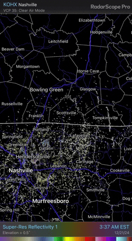
Some interesting radar obs this AM. Ft. Campbell snow band overnight:
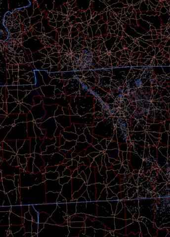
A streamer off of Lake Michigan kinda sorta held together to make it to N. TN east of Nashville this AM:
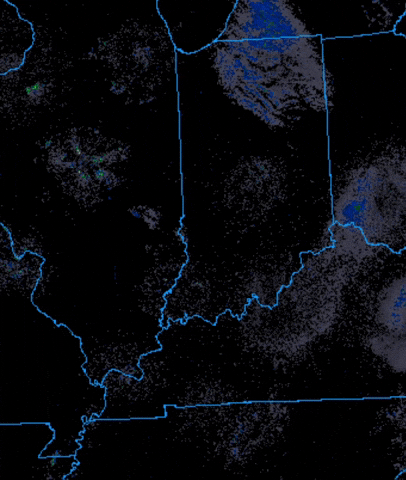
ZOOMed in:
-
2
-
-
1 hour ago, John1122 said:
The moisture isn't reaching high enough into the dz for snow here so I'm getting freezing drizzle with an occasional nickel sized flake. It's 30.6 degrees and there's a light glaze on everything.
Just walked out and same here, minus any flakes.
-
2
-
-
Flurries up here in MoCo now and a howling N wind.
-
3
-
-
Just now, Holston_River_Rambler said:
Yeah that trough hung up over the SW doth maketh me a bit nervesome.
We're firmly in MJO 6 after having spent several weeks in 4/5 and I always feel like there is a lag in the pattern over North America. I think we've seen this so many times though we're a little "once bitten twice shy" any time that trough starts to set up in the southwest.
I also don't like to to see BAMWX chest thumping on X. Bad sign.
Totally unscientific to let that to worry me, but it is what it is.
-
3
-
2
-
-
28 minutes ago, Carvers Gap said:
Crazy to see how differently the EP/GEP and GEFS are right now after d10. They converged a bit yesterday, and have diverged again overnight. Even the GFS operational is on an island. The GFS really struggled with the cold during the past few weeks. If it gets beat this time, I am going to have to retire it for a bit. OTH, if it wins....big win for American modeling. I won't say it isn't right - I learned a long time ago not to discount outliers in weather modeling. However, it looks really off. The 6z GFS is certainly plausible given climatology, and is one scenario we need to guard against....that the warm isn't just a 7 day warm-up. FTR, I do think it is wrong, but I do consider it nonetheless. Sometime in science evidence is presented which asks us to consider another solution.
Yeah that trough hung up over the SW doth maketh me a bit nervesome.
We're firmly in MJO 6 after having spent several weeks in 4/5 and I always feel like there is a lag in the pattern over North America. I think we've seen this so many times though we're a little "once bitten twice shy" any time that trough starts to set up in the southwest.
-
3
-

Winter 2024/2025 January Thread
in Tennessee Valley
Posted
At least it kicks it out and doesn't totally cut it off, but yeah it could be in error. Kind of hope it isn't though lol.