

Holston_River_Rambler
-
Posts
6,206 -
Joined
-
Last visited
Content Type
Profiles
Blogs
Forums
American Weather
Media Demo
Store
Gallery
Posts posted by Holston_River_Rambler
-
-
Finally got some really nice thunder here! Make of that what ye will for the pattern.
-
 7
7
-
-
HRRR has a pretty helicity swath over the current warned storm and paints another one over my head, later today! Joy

-
2
-
-
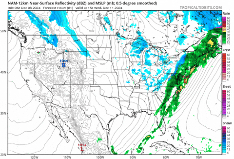
Tornado warning SW of Nashville and East of Jackson:

-
 2
2
-
-
MRX mentions possibility of a tornado tomorrow. This seems like the sort of conditional set up that has surprised us the past couple of years. I am by no means a severe enthusiast, but time of day and any potential clearing, relative storm motion, yada yada just strikes me as having some sneaky potential.
We need some thunder either way.
-
5
-
-
-
Deck measure pic, taken of course on the most elevated surface in a shady spot:


Heavy wet snow stuck to everything, especially windward:


-
3
-
-
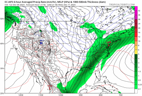
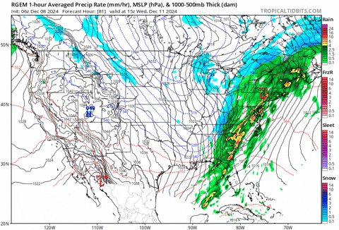
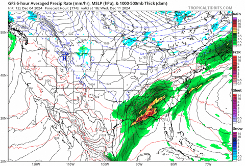
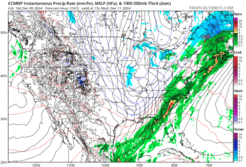
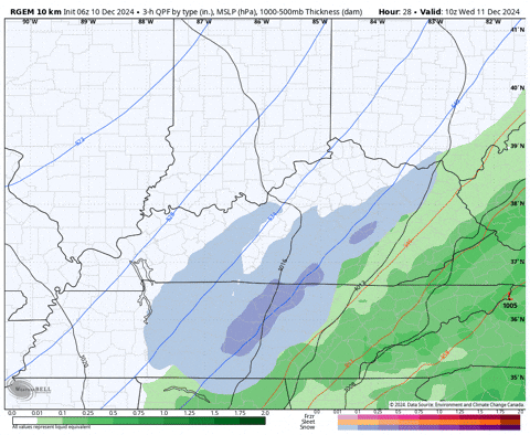
RGEM and Euro AIFS for the win in my book with this one.
Euro AIFS, last 26 runs, starting 186 hours out:
RGEM's runs, starting 80ish hours out:
Compare to the GFS 180 hours out:
Euro from 140 hours out (couldn't get a gif further than that)
and NAM from 84 hours:
Looks to me like there was a progressive bias with this particular system. RGEM I think does better with big picture stuff, NAM and HRRR are better for localized precip. type issues and convective processes.
0z Euro AIFS is still trying to honk on the system Carvers noted:
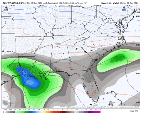
It is still bouncing around a bit though, but hey its 10 days out.
-
3
-
 1
1
-
-
-
Just now, Save the itchy algae! said:
36 and rain leaving Farragut this am. Feels close to snow!
.That was about the temp I started to turn over.
-
5
-
-
11 minutes ago, Knoxtron said:
Pouring snow on the plateau, have about a half inch currently.
I was wondering how you were doing. I actually am pretty close to your total somehow. Absolutely exceeding my expectations. As we get some daylight it is beautiful here.

-
6
-
-
Moderate snow now. A dusting for me:

-
3
-
-
Mostly snow now. I bet Knoxtron and John probably have a dusting or more lol.
-
1
-
-
Rain/snow mix for me now.
-
Cold rain here this morning. I’d say about an hour until I switch over to snow. 40 and a howling NNW wind.
-
If I could transport myself anywhere in our area tomorrow AM it would be High Knob, VA.
-
2
-
 2
2
-
 1
1
-
-
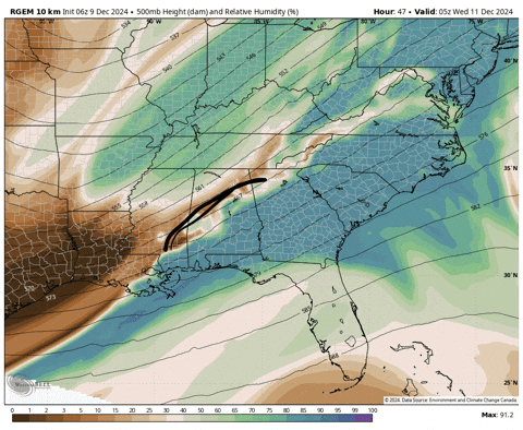
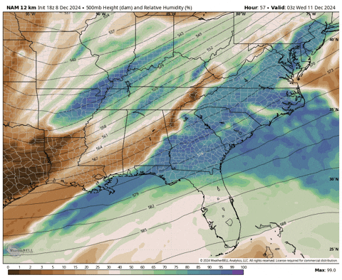
RGEM is getting even more moisture back across the Apps for tomorrow AM now, but seems to see the cold air struggling to make it over the plateau. NAM was trending toward more moisture, but is keeping the deep stuff east of Morristown at 6z
I think RGEM and Euro AIFS win this one wrt moisture. Both were going to town on this idea for a while.
Biggest problem I see now is that we're pretty deep in mild, moist air right now so I think the wait and see for cold air game is, as usual, a real threat.
 Not pretty for a "waiting on the cold air" situation.
Fortunately timing is about as good as it can get, early AM Wed, so the sme model above, shows the below:
The Bastardi algorithm is much more optimistic for MBY than the Levi Cohen algorithm:
Luckily all I have to do is wake up at my usual time and look out my window to see which turned out right.
I think Cumberland county, John, anyone up near Wise or Harlan, KY have the best shot as of now. 100% chance John and Cumberland Co change over to snow at least 45 minutes before me lol.
-
5
-
1
-
-
Honestly, IMO we are just now getting into the warmer MJO phases and figured we would have an uphill battle from here until the first week of Jan. More optimistic for me are the patterns we've had the past couple of weeks. How long has it been since we had not one, but TWO clippers slide over the Mountain Empire? Frequently in the past few years when we get a cold shot it's like a week or even 3-4 days. This one has at least lasted a couple of weeks.
Just giving it the the eyeball test, MJO seems near phase 5 to me.

I guess we'll see what happens. If we get to like Jan 1 and it looks like it will just reload into 4/5/6, probably looking at atypical (aka recent) La Nina.
-
2
-
1
-
-
This kind of reminds me of the Christmas Eve 2021 strom:
I think the above is probably the highest end this Wednesday is capable of though.
-
3
-
1
-
-
Morning RGEM holds steady. NAM continues to trend more negative and sharper with the trough.
Looks like most of this is driven by jet dynamics? I mean yeah there is def. a opportunity for some upslope after as cold air slides in, but I think what we are rooting for is a sharper, more negative trough to help draw moisture west to be lifted in the right entrance region of a strengthening jet.
NAM trend for the 500 mb trough:
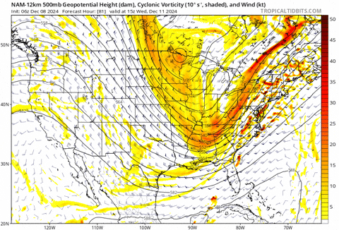
NAM jet trend: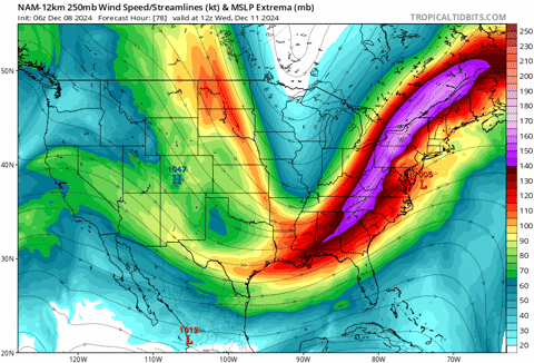
RGEM able to get more moisture backing:
 \
\
NAM is trying, but so far not as much makes it west:
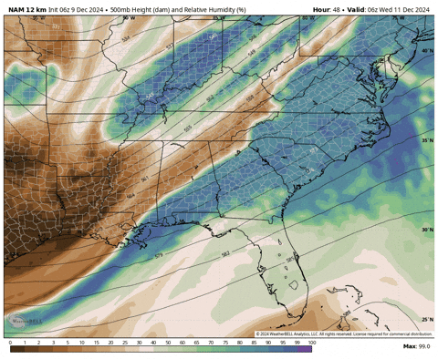
But.... the NAM looks much better this AM (above) than 18z (below):
-
3
-
1
-
-
22 minutes ago, Carvers Gap said:
SLP or wave riding a cold front.
We seem to do pretty well with these during Decembers lately.
-
5
-
-
Pretty nice burst now! Woot woot!
-
6
-
-
Still getting virga’d here
-
1
-
 1
1
-
-
30 minutes ago, John1122 said:
Sky has lowered and the temp has dropped 5 degrees in the last 45 minutes. Flakes should be reaching here soon. Had some virga so far.
Same boat here. Still virga, but a cold wind is blowing and the skies are lowering.
-
1
-
-
19 minutes ago, Carvers Gap said:
Thunder in the mountains....
I noticed some strikes last week in the middle of the night on the radar app near Clinton and Knoxville. Hopefully that portends well for this evening. Sadly one on the most important indices is not looking good. The ELK index is heretofore absent.
-
4
-

Winter 2024/2025 December Thread
in Tennessee Valley
Posted
MRX has modified their expectations: