

Holston_River_Rambler
-
Posts
6,206 -
Joined
-
Last visited
Content Type
Profiles
Blogs
Forums
American Weather
Media Demo
Store
Gallery
Posts posted by Holston_River_Rambler
-
-
A few flurries here in Morgan County with this clipper
-
 2
2
-
-
GFS and Euro have ye olden clipper around hr 130. Maybe we can get the +TNH to make clippers work again for the TN Valley?
-
4
-
 1
1
-
-
We got snow here in MoCo
-
4
-
-
If the radar is right it should start up here in a few. I’m pretty far SW relative to this system so we’ll see how it goes!
-
4
-
-
Fog rolling over the mountains near Frozen Head state Park this AM:

-
4
-
 1
1
-
-
Some huge trees floating down from the N fork of the Holston and I’ve actually seen a few otters out swimming on the Hawkins county side of the river.
-
2
-
-
Just drove up to Kingsport from Morgan county. A few small trees down on roads in my neighborhood near Coalfield, but nothing blocking the roads. Looked like a tree was down near the ridgefields market in Kingsport, but someone had cleaned it up. A lot of tractor trailers were taking a break on exit ramps on 81. Fortunately it was mostly a head wind driving up 81 so it wasn’t too bad of a drive.
-
Was just reading in the main tropical thread that recon had to abort from the eye due to an extreme updraft. Apparently similar wording was used for Hugo? Of course extreme updrafts in hurricane eyes may be pretty normal too.
https://x.com/erin_kwx/status/1839453447902433339?s=46&t=KMZWtmm9xSWkLJtvZXn39g
edit to add the link to that x post
-
2
-
-
Just now, Carvers Gap said:
@Holston_River_Rambleranother interesting analog might be the superstorm of ‘93. Similar origin, track, and strength. Wonder if it had a low to the west?
I think that one just formed and raced poleward. But yeah maybe a similar track. May be driving to Kingsport tomorrow AM. Could be fun. Hopefully I survive if I end up going!
-
1
-
-
Yeah I wasn't necessarily trying to make people think it would be the same, just that Fujiwara getting it inland quickly was the similarity I was looking at. Sorry of that came across wrong.
One thing in the NWS Hugo site shows is a compilation of what locals remember as the worst tropical system and oddly enough there was a similar situation to Hugo (with regards to flooding I suspect because of the SLPs recorded) in 1940 in the NC mountains:


-
2
-
-
Did Hugo have a upper low slinging it inland too? I was just looking at a model for Helene and the long outflow cloud deck aiming at the upper low seems to remind me of Hugo:
Helene:

Hugo:

Color schemes aren't the same, but the long outflow upper cloud deck kind of seems similar to me.
Actually, I just realized I could go look at reanalysis and yeah, Hugo had a deep south upper low:

-
3
-
-
-
Woo hoo, actual rainfall on the plateau this AM! Hope everyone who has a chance can get a shower!
-
5
-
-
16 hours ago, nrgjeff said:
You drove the Million Dollar Highway? No guard rails it's white knuckles.
We did. First time for me. What an amazing drive! Started snowing around Silverton and it was 29 with a nice dusting above Ouray. We were worried we might have to drive 8 hours back to Durango via Grand Junction and Moab, lol. There was a persistent snow band on that pass and while the students we take on the trip were relaxing in the hot springs, I was frantically checking the satellite since there was some clearing over SW Utah. At 5PM we attempted the pass. The snow had stopped but the roads were wet and it was in the upper 20s above 10000'. There were motorcycles and a semi that we met near the top of the pass, so that gave us some confidence. Made it back to Durango by 7!
Here is a pic coming down into Ouray for those who haven't seen this drive:

Luckily it was foggy and we couldn't see the 1000' drop off to the left. If any of y'all ever have the chance to do that drive and go to the Ouray Hot springs, I highly recommend!

-
2
-
 1
1
-
-
Hope everyone had a good summer!
Occasional cold fronts and football have prodded me out of my AMWx estivation.
Here are some sky photos from my annual May trip to the SW:
Mts above Flagstaff, AZ:

AM snow over the Grand Canyon:

PM storms over the grand canyon:

The aurora from Mather campground:

fun sunrise clouds over southern Utah:

distant virga storm as seen from around 11,000 feet near Brian head in Utah:

first time I've seen differential heating storms growing with a foot plus of snow on the ground (also Brian Head):

Kodachrome basin sky:

Golden hour over the La Sal mts near Moab, UT:

same spot but at night with fullish moon and an iphone:

late May snow over Silverton, CO:

occasionally tornadic storm in Oklahoma near Lake Eufaula:

-
2
-
1
-
-
It's been pretty sad watching the precip chances slowly ebb for plateau areas as Francine has moved toward us. Had a 20 second decent shower and that's about it. Some Hires models showing some storm chances this PM. MRX also notes the non 0 tornado risk in southern plateau and valley areas.
-
2
-
-
Worst possible sky cover here in Harriman that I could imagine, lol.
-
Found a Facebook video with the Sunbright tornado
https://www.facebook.com/justan.spurling/videos/1654843611997812
-
2
-
1
-
 1
1
-
-
Tornado warning north of me near Sunbright.
-
1
-
-
Sadly everything looks too progressive for my storm early next week. Euro AIFS was the first to wash it out, so maybe its on to something with the next one.
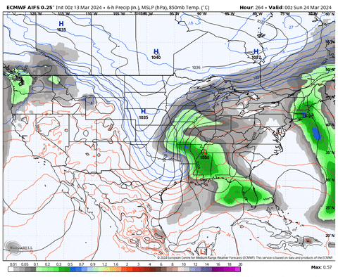
At this point, I'd just like to see a strong storm north and east of the Missouri/ Mississippi rivers. I think all string storms have to for the lee of the Rockies and aim at the lakes recently.
-
1
-
-
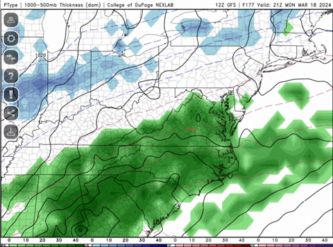
12z GFS = yum
-
3
-
-
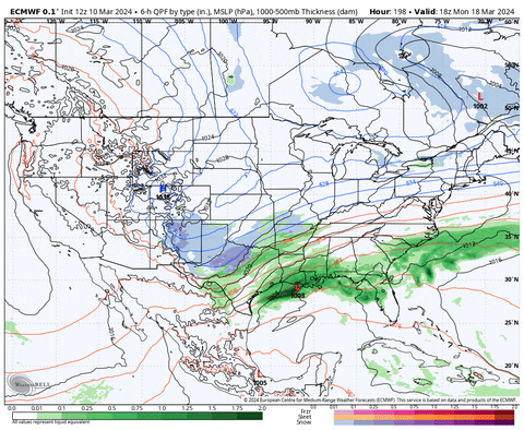
Not there yet, but some improvement:
-
3
-
-
Found this in the main ENSO thread:

I could be reading it wrong, but it looks like SST anomalies by year and latitude. Looks like something tipped around 2003 and again after the super Nino in 2015-16. I'd love to see that chart going back another 100 years, but that could also be more depressing, lol.
-
1
-
-
GFS has some deep troughs this morning and the Euro control (basically the new Euro now) has clipper after clipper after clipper. If I was above 3500 feet WV, VA, or NC mountains, I'd love the Euro's look.
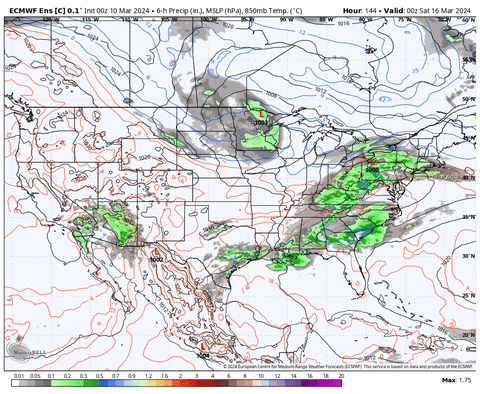
Now that is finally a pattern look that matches the developing ENSO state. Exactly what you'd expect from a Nina.

Maybe that is an indication we get some nice MCSs by June? I love me some MCSs, lol.
-
2
-
1
-
Winter 2024/2025 December Thread
in Tennessee Valley
Posted
Sorry for your loss Dan.
NAM is getting pretty enthused about the next clipper early next week. The current one seems to be slightly outperforming wrt precip on the southern edge. I was wondering how it might verify.