purduewx80
-
Posts
1,705 -
Joined
Content Type
Profiles
Blogs
Forums
American Weather
Media Demo
Store
Gallery
Everything posted by purduewx80
-
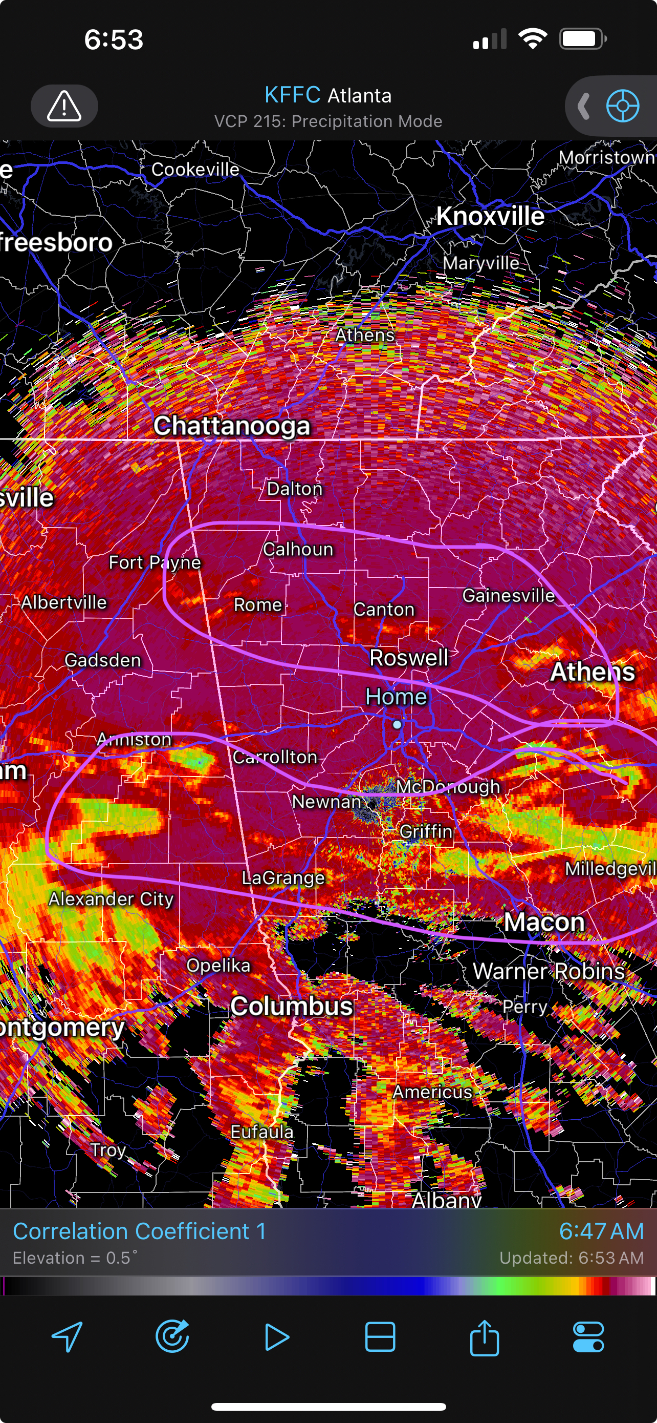
Easy over. That’s a band of 1-2”/hour moving across south Fulton now.
-
1/10-11 super awesome winter SE OBS thread
purduewx80 replied to strongwxnc's topic in Southeastern States
Can see the delineation in precip types quite well on CC. Precip is sleet or mixed at first prior to saturation occurring and then flips to snow (N/E of ATL now), with the warmer air aloft evident in the south metro and along/S of I-20 in AL.
-
1/10-11 super awesome winter SE OBS thread
purduewx80 replied to strongwxnc's topic in Southeastern States
Mixed at first but all wet snow in West End ATL now with massive aggregates ~2” across -
Temps aloft aren't going to verify cold with the strong LLJ, but surface winds probably will with the damming setup. Northern Gwinnett is likely to be front and center for the worst impacts from the ice storm. Yes, there will be snow longer there, but it will almost certainly switch over to FZRA for the duration.
-
Exactly right. Ridge-top winds will be ripping out of the S/SW, which is downsloping and drying off the Blue Ridge/Mt. Pisgah.
-
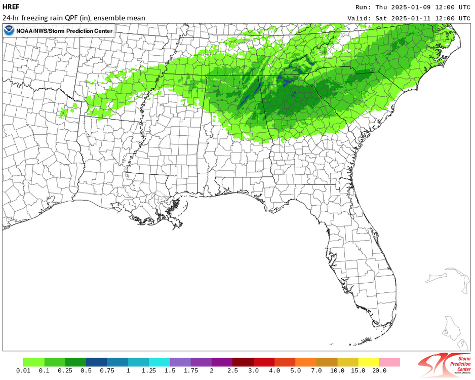
The HREF is pretty scary in terms of the ice storm potential, but the CAMS may be too cold with too much QPF, though props to the Canadian if it occurs. Will have to watch trends HREF guidance on the 00Z and 12Z runs. Have also noticed stronger SE surface gusts showing up tomorrow, in addition to what was already expected Saturday morning (NW). Some downslope enhancement could occur tomorrow northwest of terrain features with the strong E/SE flow just off the surface. Sig impacts seem pretty likely along and especially north of I-20 in GA and adjacent areas. 12Z Fri-Sat totals below, using the FRAM algorithm.
-
Looking at soundings, its wetbulb temps are mostly near to below freezing, with a warm nose around 700mb, implying sleet may occur at onset in parts of S GA. The snow depth and Kuchera maps are much lower.
-
Flurries in Sandy Springs
-
2024 Atlantic Hurricane Season
purduewx80 replied to Stormchaserchuck1's topic in Tropical Headquarters
Curious to see how the next western Caribbean system plays out with a strong sub-tropical ridge over the Bahamas and a stout -NAO potentially developing. The Pacific pattern is what ends up being important for a northward track due to how it affects the breakdown of ridging from the Yucatan channel into the western Gulf.
-
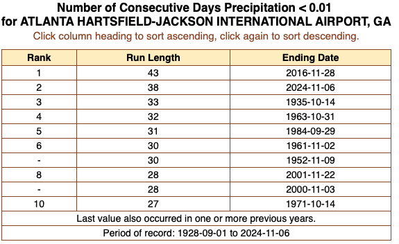
ATL is closing in on its longest stretch of no measurable rain. Trace amounts have been reported 6 of the last 7 days. Seems like the streak will end this weekend or ahead of the front early next week, but I'm not counting on much.
-
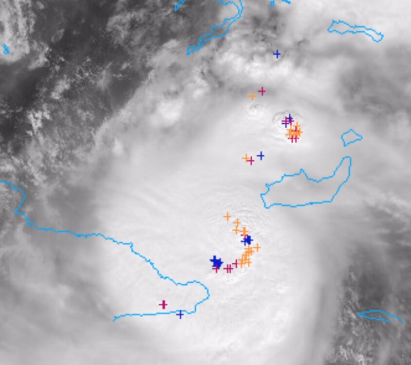
There is evidence of northwesterly shear on water vapor imagery this evening. I see the 18Z ECMWF and GFS both show an increase for an ~18 hour period before it abates late tomorrow. Seems like all that dry air over the Gulf would interrupt the convection further, but there may be room for another round of deepening on the more southerly track the Euro is showing if the circulation isn't fully disrupted.
-
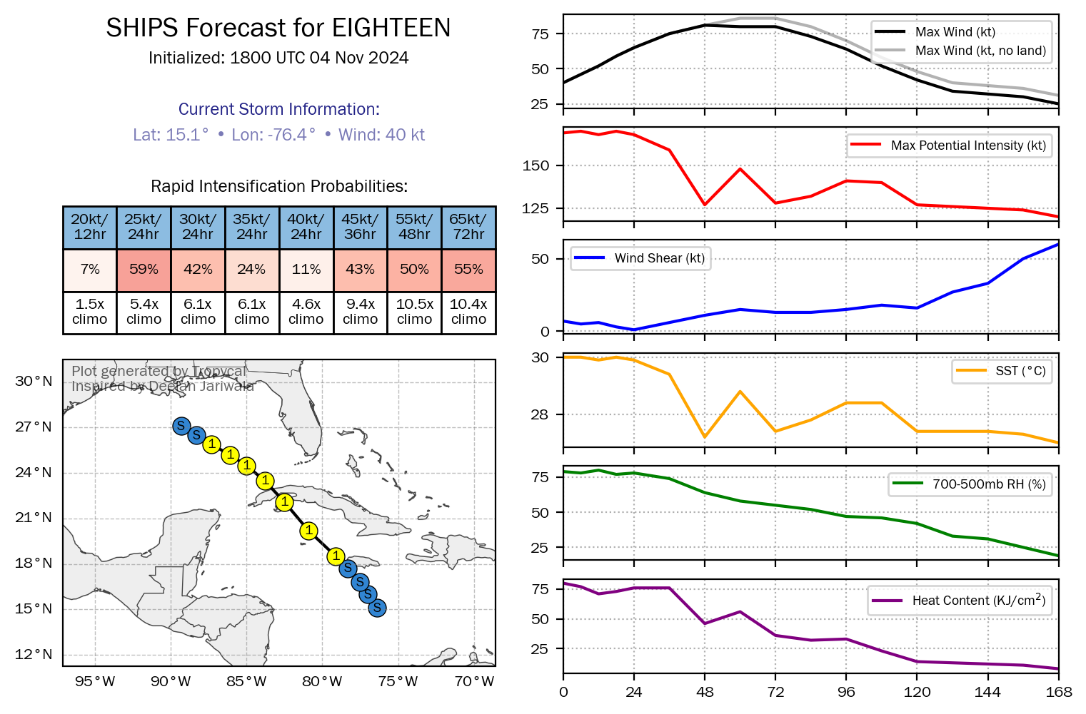
RI probs are exceedingly high from the 18Z SHIPS.

-
The 12Z hurricane regional models probably aren't to be trusted without a well-defined center yet, but they do show how the vortex missing Jamaica could result in a stronger system over Cuba and/or the Gulf. Would be wild to get another RI major this year.
-
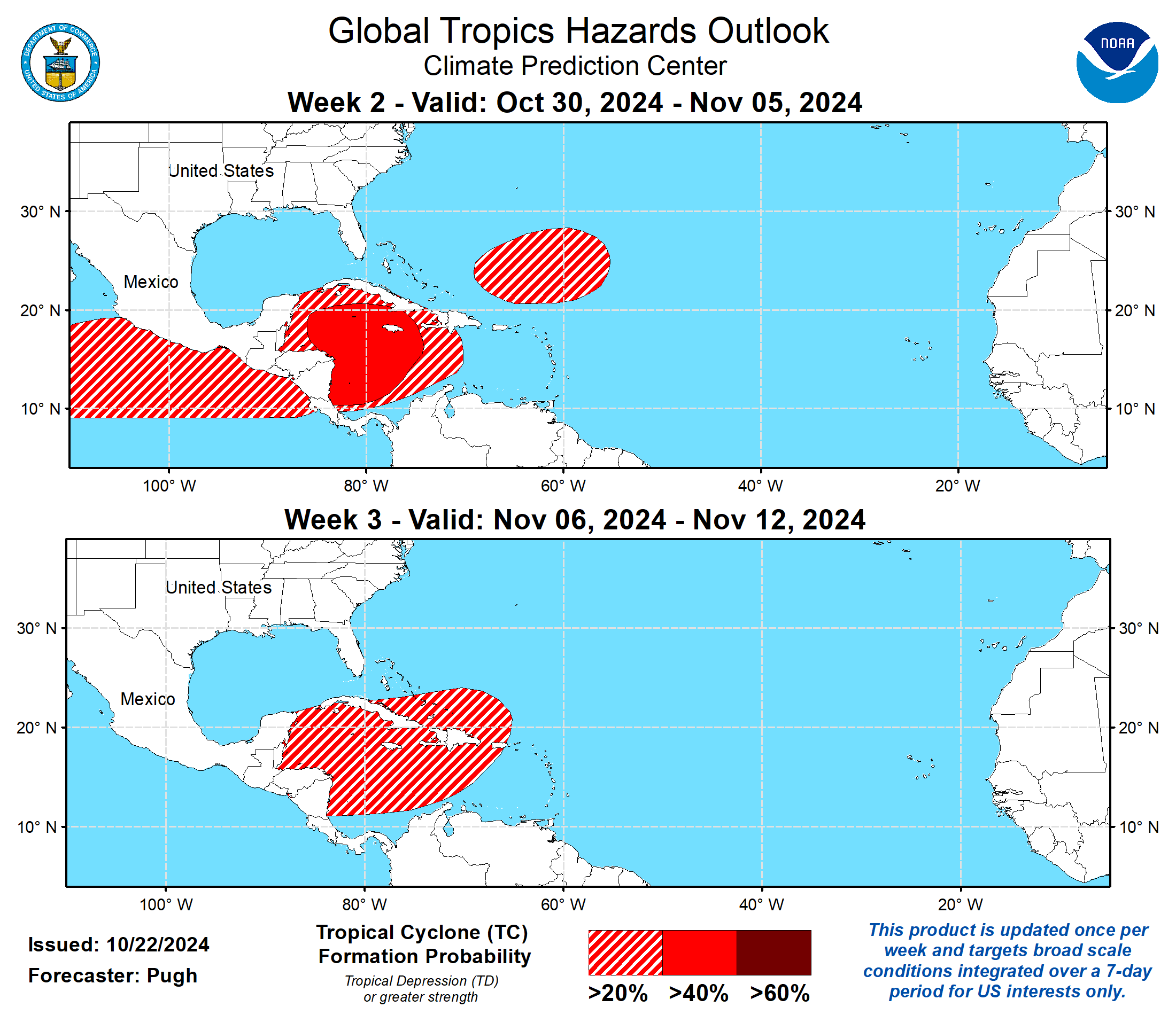
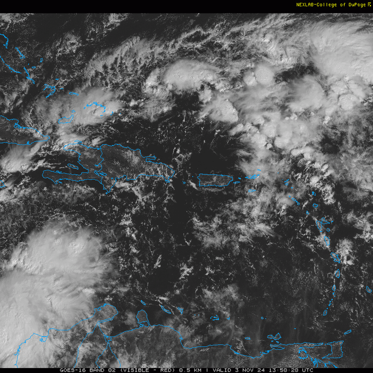
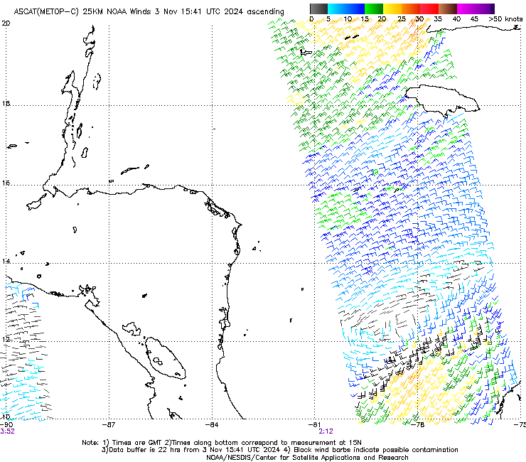
Will be curious to see how quickly it tightens up today. Looks increasingly organized on satellite, but ASCAT is still an elongated mess. The low north of DR is what is forecast to evolve into an inverted trough that effectively focuses a PRE in the Southeast mid-week. There may be a sharp cut-off between minimal rain and significant flooding in parts of GA and SC. Rain in Florida would certainly be unwelcome with lingering flooding there from Milton, as well.
-
2024 Atlantic Hurricane Season
purduewx80 replied to Stormchaserchuck1's topic in Tropical Headquarters
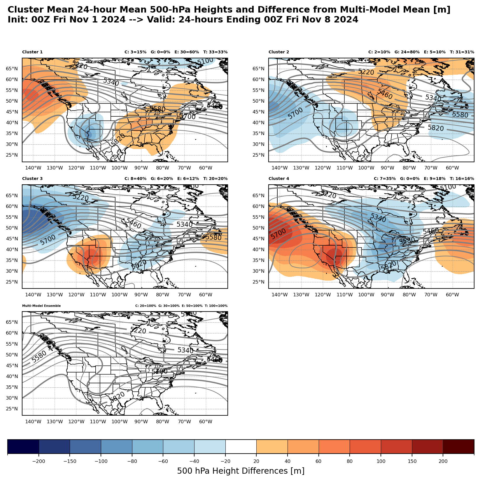
There are wild differences with how this impacts weather in the Southeast next week. GEPS and increasing EPS members are as bad as another PRE and follow-up TC in some areas impacted by Helene, but GEFS are much drier with stronger ridging. Aside from not knowing where the Caribbean system eventually develops and tracks, the Pacific pattern and wave cutting off in the Southwest are the other parts of the uncertainty.

-
2024 Atlantic Hurricane Season
purduewx80 replied to Stormchaserchuck1's topic in Tropical Headquarters
CPC’s update picks up on the enhanced odds for development down in the western Caribbean.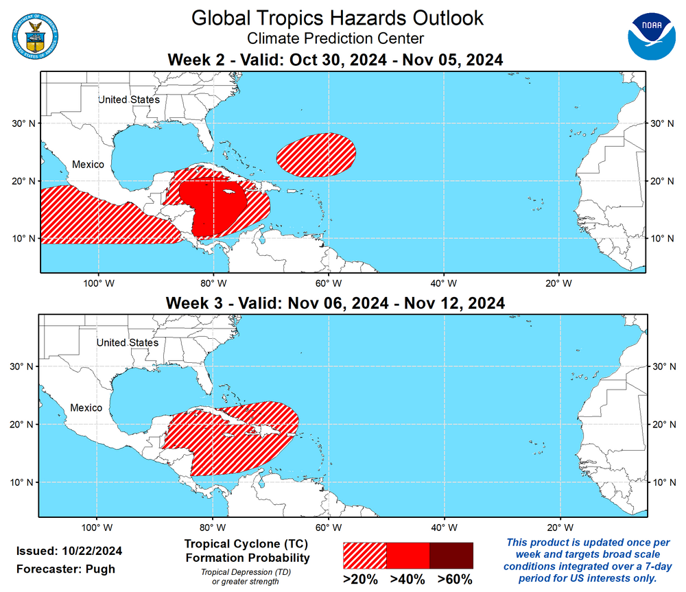
-
2024 Atlantic Hurricane Season
purduewx80 replied to Stormchaserchuck1's topic in Tropical Headquarters
Sure looks to be trending down from where it is now, with a handful of sharply negative members by early November. CFS and last night’s weeklies take it there, as well. Not saying whatever develops in the Caribbean makes it into the US but it can definitely not be ruled out.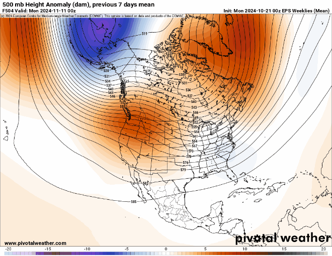
-
2024 Atlantic Hurricane Season
purduewx80 replied to Stormchaserchuck1's topic in Tropical Headquarters
12Z GEFS has a lot more members coming up into south FL late next week. Gotta watch NAO trends later in November, as any Greenland block could send something into the East Coast, too. -
Yup, the other one coming out of Biloxi turned back. Probably too deep in Cuban airspace now.
-
Semantics maybe, but I see it as a list of reasons there was insufficient data to classify it.
-
Looks like the AF will be in it a good part of the afternoon. I imagine there’s some concern at GTMO. Lightning taking off in line with the radar@NorthHillsWxposted.
-
The HWRF had it as a cat 2 or 3 around this time off and on since early last week, but it was very inconsistent.
-
Kinda hard to say NHC dropped the ball with minimal model support the last few days and all scatterometer data showing an open circulation. HWRF was the only model really showing much coming out of it. Even when it looked like a TC on satellite Thursday, recon found no westerly surface winds as ASCAT showed. Chalk it up to being a tiny circulation, I guess. Suspect we get RI into a hurricane today looking at the outflow in a light shear and warmer oceanic environment.
-
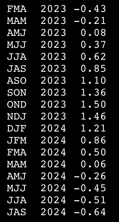
And yet the updated RONI moved deeper into Niña territory. Still not seeing AS numbers for the MEIv2.

-
2024 Atlantic Hurricane Season
purduewx80 replied to Stormchaserchuck1's topic in Tropical Headquarters
Most of the MJO plots are putting the Atlantic back in play around the first of November. Not sure about CONUS threats, but the Caribbean sure could get busy for a couple of weeks.