

OrdIowPitMsp
-
Posts
2,769 -
Joined
-
Last visited
Content Type
Profiles
Blogs
Forums
American Weather
Media Demo
Store
Gallery
Everything posted by OrdIowPitMsp
-
Minneapolis finished with 0.13” of precipitation for the month of January with 2.0” falling as snow.
-
Diurnal swings are impressive this time of year. After a high of 55 yesterday we got down to 28 with heavy freezing fog overnight. Roads are slippery.
-
New record high of 55 in Minneapolis smashing the old record of 46. We missed tying the all time January record by 1 degree. I was working outside in a t-shirt today.
-
Woohoo 1st place!! February 1878 is the 6th warmest on record for Minneapolis, so that’s the number to beat.
-
I am starting to really believe 1877-78 is going down this year, or at least we get close. It’s a similar setup with AGW and UHI boosting things a bit. The lack of any snowpack up north after this warmup will only hamper the ability to see normal wintertime temps moving forward. The main difference is the lakes have actually held some ice this season, versus 77-78 when there are many reports of lakes never icing over completely.
-
Closing out January with record high temps across Minnesota today. The all time January record of 56 in Minneapolis might be in jeopardy today.
-

Winter 2023/24 Medium/Long Range Discussion
OrdIowPitMsp replied to Chicago Storm's topic in Lakes/Ohio Valley
Wake up > check 384hr GFS > less then 0.10” precip for Minneapolis wash rinse repeat -
Winter 2023/24 Medium/Long Range Discussion
OrdIowPitMsp replied to Chicago Storm's topic in Lakes/Ohio Valley
We’ve got a long way to go. It can snow here into May, and April 2018 saw over 25” of snow, but the trends this winter are undeniable. I’m more concerned if we don’t see any precip versus it falling as snow. Don’t want a 4th straight summer of drought and smoke. -
Winter 2023/24 Medium/Long Range Discussion
OrdIowPitMsp replied to Chicago Storm's topic in Lakes/Ohio Valley
Warmest winter on record is gonna be locked up by mid month for mby. Might as well make it the least snowy as well and hit the futility daily double. -
Temps have way overachieved today in Minneapolis. It’s currently 48 breaking the old record of 47 from 1892.
-
High of 33 today with freezing fog. Coolest day in the next 10.
-
The spread in monthly precipitation across the subforum is impressive. Minneapolis is sitting at 0.13” month to date with nothing on the horizon.
-
Winter 2023/24 Medium/Long Range Discussion
OrdIowPitMsp replied to Chicago Storm's topic in Lakes/Ohio Valley
Wildfire season will be rocking with full run GFS precip maps like this for MN and points NW. -
Winter '23-'24 Piss and Moan/Banter Thread
OrdIowPitMsp replied to IWXwx's topic in Lakes/Ohio Valley
The great upper midwest snow hole of winter 23/24 is very evident on the total seasonal snowfall map. Most of northern Minnesota is around the 5th to 10th percentile for current average snow depth.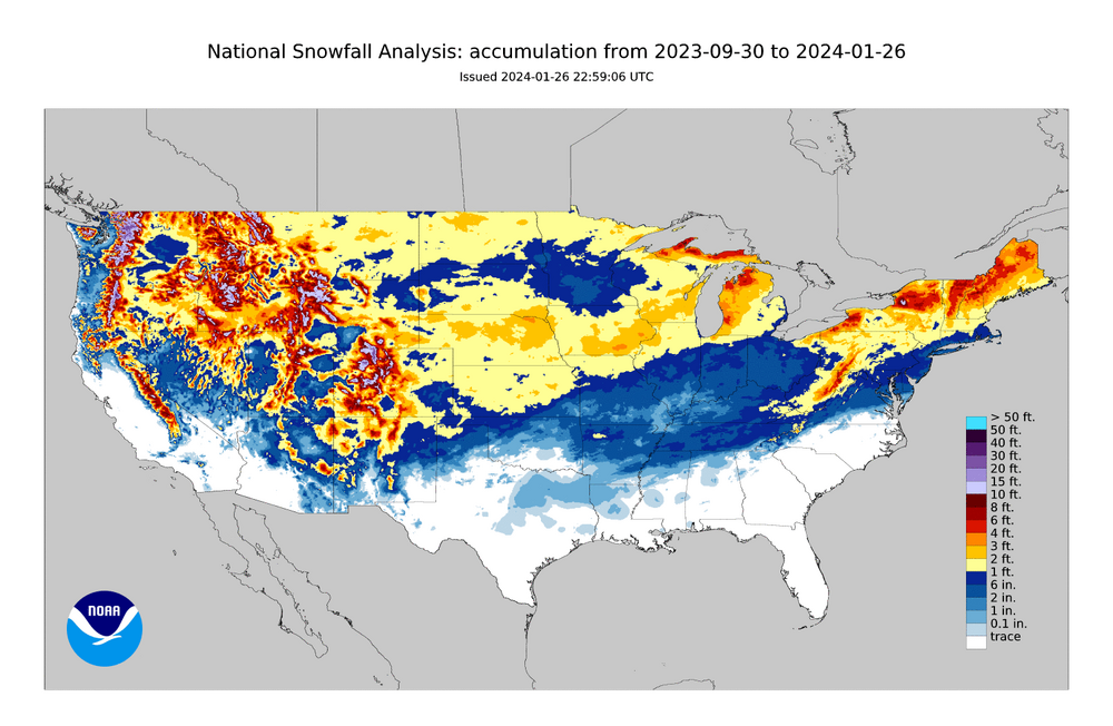
-
Winter 2023/24 Medium/Long Range Discussion
OrdIowPitMsp replied to Chicago Storm's topic in Lakes/Ohio Valley
Yes you are correct. Off by a mere decade. February 1878 is the 6th warmest all time for Minneapolis. We need to aim for a top 5 warmest February to have a shot at the record. -
Winter 2023/24 Medium/Long Range Discussion
OrdIowPitMsp replied to Chicago Storm's topic in Lakes/Ohio Valley
Chasing the ghost of winter 1887/1888 for warmest on record. Would be pretty cool if April and May end up our snowiest months this winter. Right now the 2.7” in October takes the top spot. -
Winter 2023/24 Medium/Long Range Discussion
OrdIowPitMsp replied to Chicago Storm's topic in Lakes/Ohio Valley
Starting to feel more confident that a top 5 warmest and least snowy winter might be in the cards here. -
Thank you Iowa for the dense snowpack, letting us get in on the freezing fog too. Almost busted my ass walking in the parking lot this morning.
-
Winter '23-'24 Piss and Moan/Banter Thread
OrdIowPitMsp replied to IWXwx's topic in Lakes/Ohio Valley
Ugh wtf. Throw the book at them. -
Winter 2023/24 Medium/Long Range Discussion
OrdIowPitMsp replied to Chicago Storm's topic in Lakes/Ohio Valley
Looks pretty typical for the lower arctic to me. -
Winter 2023/24 Medium/Long Range Discussion
OrdIowPitMsp replied to Chicago Storm's topic in Lakes/Ohio Valley
Yeah nothing you can do but marvel at how drastically things can change YOY in our region. I’ve still had (scant) snowcover imby longer then most in this subforum, haven’t been above freezing since January 5th. It’s still winter here. -
Winter 2023/24 Medium/Long Range Discussion
OrdIowPitMsp replied to Chicago Storm's topic in Lakes/Ohio Valley
Smokey skis are the new normal in the summer around here. It stinks (literally) but 20th century style fire suppression might be partially to blame. -
Winter 2023/24 Medium/Long Range Discussion
OrdIowPitMsp replied to Chicago Storm's topic in Lakes/Ohio Valley
Extended looks very dry in Minnesota. Top 10 driest January is closing in on a lock. Typical of a nino around here. -
Winter 2023/24 Medium/Long Range Discussion
OrdIowPitMsp replied to Chicago Storm's topic in Lakes/Ohio Valley
Great skiing weather. Winter isn’t going anywhere. -
Winter 2023/24 Medium/Long Range Discussion
OrdIowPitMsp replied to Chicago Storm's topic in Lakes/Ohio Valley
Got a lot of time to make new accounts with frozen palms huh?


