BTRWx's Thanks Giving
-
Posts
3,332 -
Joined
-
Last visited
Content Type
Profiles
Blogs
Forums
American Weather
Media Demo
Store
Gallery
Everything posted by BTRWx's Thanks Giving
-

Jan 24-26 Weekend Snow and Sleetfest Model Thread Part Tres
BTRWx's Thanks Giving replied to H2O's topic in Mid Atlantic
That's the lower resolution NAM. -
Jan 24-26 Weekend Snow and Sleetfest Model Thread Part Tres
BTRWx's Thanks Giving replied to H2O's topic in Mid Atlantic
They look pretty similar to me at that hour. -
January 24-26: Miracle or Mirage JV/Banter Thread!
BTRWx's Thanks Giving replied to SnowenOutThere's topic in Mid Atlantic
Watch DCA get above freezing tomorrow. -
Jan 24-26 Weekend Snow and Sleetfest Model Thread Part Tres
BTRWx's Thanks Giving replied to H2O's topic in Mid Atlantic
Any word if the 1km NAM will be run over us? -
Jan 24-26 Weekend Snow and Sleetfest Model Thread Part Tres
BTRWx's Thanks Giving replied to H2O's topic in Mid Atlantic
2mb stronger high compared to a couple runs ago and slightly slower progression on the 18z 3km NAM. -
Jan 24-26 Weekend Snow and Sleetfest Model Thread Part Tres
BTRWx's Thanks Giving replied to H2O's topic in Mid Atlantic
The only difference I see is the radar penetration into sw WV. -
Jan 24-26 Weekend Snow and Sleetfest Model Thread Part Tres
BTRWx's Thanks Giving replied to H2O's topic in Mid Atlantic
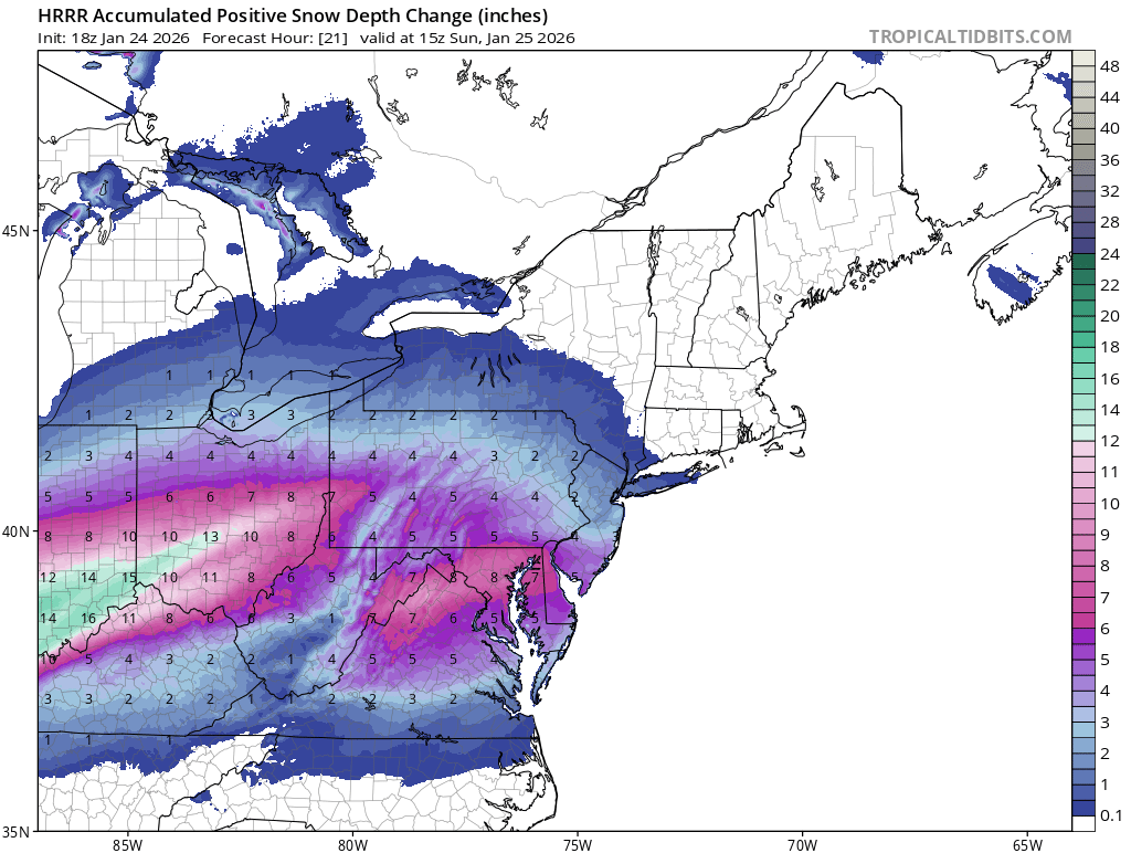
ttb has 6-7" as of 15z. Not bad
-
January 24-26: Miracle or Mirage OBS Thread!
BTRWx's Thanks Giving replied to Jebman's topic in Mid Atlantic
Please move to Alexandria. -
Jan 24-26 Weekend Snow and Sleetfest Model Thread Part Tres
BTRWx's Thanks Giving replied to H2O's topic in Mid Atlantic
This is a really interesting read about sleet! https://www.accuweather.com/en/weather-blogs/weathermatrix/incredible-sleet-stories-vol-i/46374 -
Jan 24-26 Weekend Snow and Sleetfest Model Thread Part Tres
BTRWx's Thanks Giving replied to H2O's topic in Mid Atlantic
I'm expecting 3-6" snow, 1-3" sleet, .10" freezing rain DCA. -
Jan 24-26 Weekend Snow and Sleetfest Model Thread Part Tres
BTRWx's Thanks Giving replied to H2O's topic in Mid Atlantic
2 more runs -
Jan 24-26 Weekend Snow and Sleetfest Model Thread Part Tres
BTRWx's Thanks Giving replied to H2O's topic in Mid Atlantic
Heavy too! -
Jan 24-26 Weekend Snow and Sleetfest Model Thread Part Tres
BTRWx's Thanks Giving replied to H2O's topic in Mid Atlantic
It's okay, but we don't have a lot of room for another nudge in the wrong direction. -
Jan 24-26 Weekend Snow and Sleetfest Model Thread Part Tres
BTRWx's Thanks Giving replied to H2O's topic in Mid Atlantic
Sorry, that's 18z. Pivotal doesn't have 15z. -
Jan 24-26 Weekend Snow and Sleetfest Model Thread Part Tres
BTRWx's Thanks Giving replied to H2O's topic in Mid Atlantic
It definitely trended north since 0z. -
Jan 24-26 Weekend Snow and Sleetfest Model Thread Part Tres
BTRWx's Thanks Giving replied to H2O's topic in Mid Atlantic
Hr24 looks a nudge warmer, but also appears to be heavier with snow for D.C. -
Jan 24-26 Weekend Snow and Sleetfest Model Thread Part Tres
BTRWx's Thanks Giving replied to H2O's topic in Mid Atlantic
The sounding at 15z will be very important. -
Jan 24-26 Weekend Snow and Sleetfest Model Thread Part Tres
BTRWx's Thanks Giving replied to H2O's topic in Mid Atlantic
Slight nudge north at hr12 compared to 0z. -
Jan 24-26 Weekend Snow and Sleetfest Model Thread Part Tres
BTRWx's Thanks Giving replied to H2O's topic in Mid Atlantic
Now she's running! -
Jan 24-26 Weekend Snow and Sleetfest Model Thread Part Tres
BTRWx's Thanks Giving replied to H2O's topic in Mid Atlantic
My bad, I think Pivotal just added the 12z tag without any maps. lol -
Jan 24-26 Weekend Snow and Sleetfest Model Thread Part Tres
BTRWx's Thanks Giving replied to H2O's topic in Mid Atlantic
Euro is starting. -
Jan 24-26 Weekend Snow and Sleetfest Model Thread Part Tres
BTRWx's Thanks Giving replied to H2O's topic in Mid Atlantic
Valentine's Day 2007 is the top second analog for 24h. Could this actually not become as intense now? https://www.eas.slu.edu/CIPS/ANALOG/Event.php?reg=EC&fhr=F036&rundt=2026012412&dt=2007121612&HH=0&map=SYN1 -
Jan 24-26 Weekend Snow and Sleetfest Model Thread Part Tres
BTRWx's Thanks Giving replied to H2O's topic in Mid Atlantic
Are there any historical records of sleet alone? -
Jan 24-26 Weekend Snow and Sleetfest Model Thread Part Tres
BTRWx's Thanks Giving replied to H2O's topic in Mid Atlantic
It better resembles the terrain and elevation. -
Jan 24-26 Weekend Snow and Sleetfest Model Thread Part Tres
BTRWx's Thanks Giving replied to H2O's topic in Mid Atlantic
Isotherms trended north.