Thinksnow18
-
Posts
4,144 -
Joined
-
Last visited
Content Type
Profiles
Blogs
Forums
American Weather
Media Demo
Store
Gallery
Everything posted by Thinksnow18
-
Upstate/Eastern New York
Thinksnow18 replied to BuffaloWeather's topic in Upstate New York/Pennsylvania
So a miss??? -
Upstate/Eastern New York
Thinksnow18 replied to BuffaloWeather's topic in Upstate New York/Pennsylvania
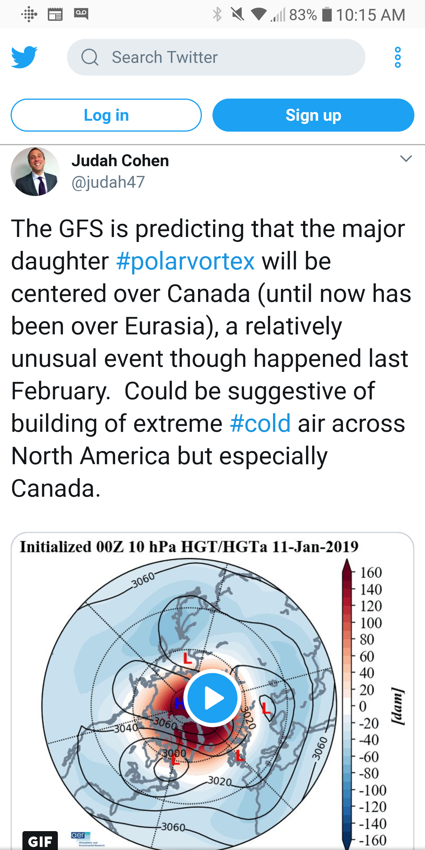
This is going to be a very exciting period for sure...all models showing the PV right above the upper great lakes in Ontario with WSW winds in the mean most of next week. It's hard not to get over excited at this point...but I'm trying to keep it in check!!! -
Upstate/Eastern New York
Thinksnow18 replied to BuffaloWeather's topic in Upstate New York/Pennsylvania
Mike was adamant. I think this next 6 to 8 weeks has the chance to be epic. -
Upstate/Eastern New York
Thinksnow18 replied to BuffaloWeather's topic in Upstate New York/Pennsylvania
Just caught the weather on WIVB in buffalo...the met is Mike Cejka, decent enough but never seems to over hype, in fact I used to call him conservative Mike (amongst other things, local folks know what I'm referring to) because he would wet blanket everything...well, he just showed a weather map/graph that he believes this upcoming pattern will last about 60 days and the worst is coming by end of month and all of February. He also has the area for a very impactful storm on Saturday followed by bitter cold there after. -
Upstate/Eastern New York
Thinksnow18 replied to BuffaloWeather's topic in Upstate New York/Pennsylvania
So the 0z and 6z Goofus has the weekend system much more suppressed leaving WNY with a few inches...on the other hand the EURO (per mid-Atlantic blog) still looks great for all upstate. My money in a medium range is on the EURO, not because I want it, but it had the track if this storm that just hit MA sniffed out 2 days before GFS came around to it. -
Upstate/Eastern New York
Thinksnow18 replied to BuffaloWeather's topic in Upstate New York/Pennsylvania
I think we're over thinking this coming event. It is a good match for the trough that pushes through on Wednesday and stalls the front just to our east allowing the LP system from the south to push NE along that front. I think we are in store for a good old fashioned snowstorm with L. Ontario enhancement. -
Upstate/Eastern New York
Thinksnow18 replied to BuffaloWeather's topic in Upstate New York/Pennsylvania
That run would satisfy me for the rest of winter. -
Upstate/Eastern New York
Thinksnow18 replied to BuffaloWeather's topic in Upstate New York/Pennsylvania
So the really strange part or fascinating part is the date of the 85 Blizzard and the timeframe we are watching...just saying... -
Upstate/Eastern New York
Thinksnow18 replied to BuffaloWeather's topic in Upstate New York/Pennsylvania
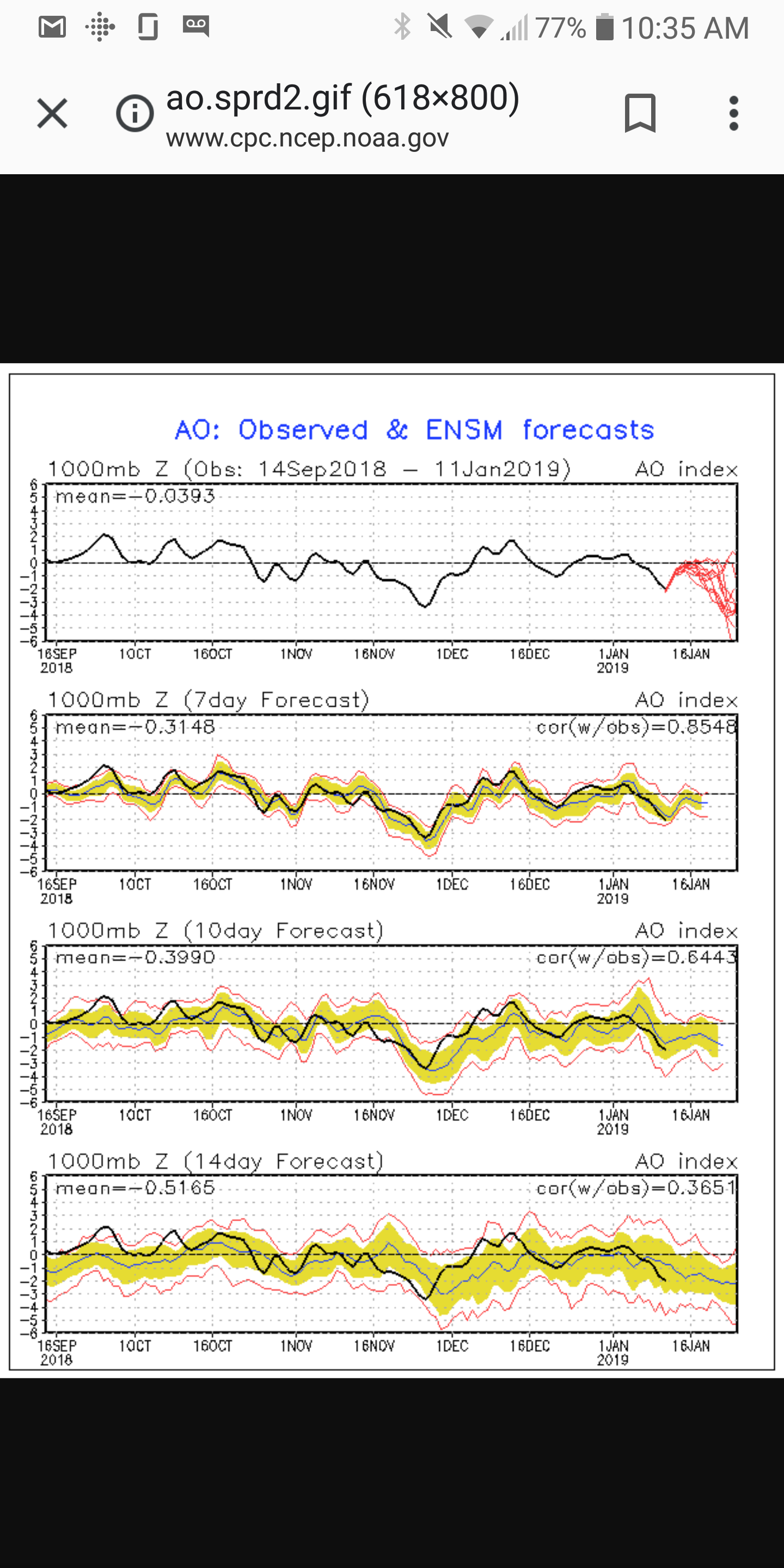
Good thing that model is as reliable as a broken compass... -
Upstate/Eastern New York
Thinksnow18 replied to BuffaloWeather's topic in Upstate New York/Pennsylvania
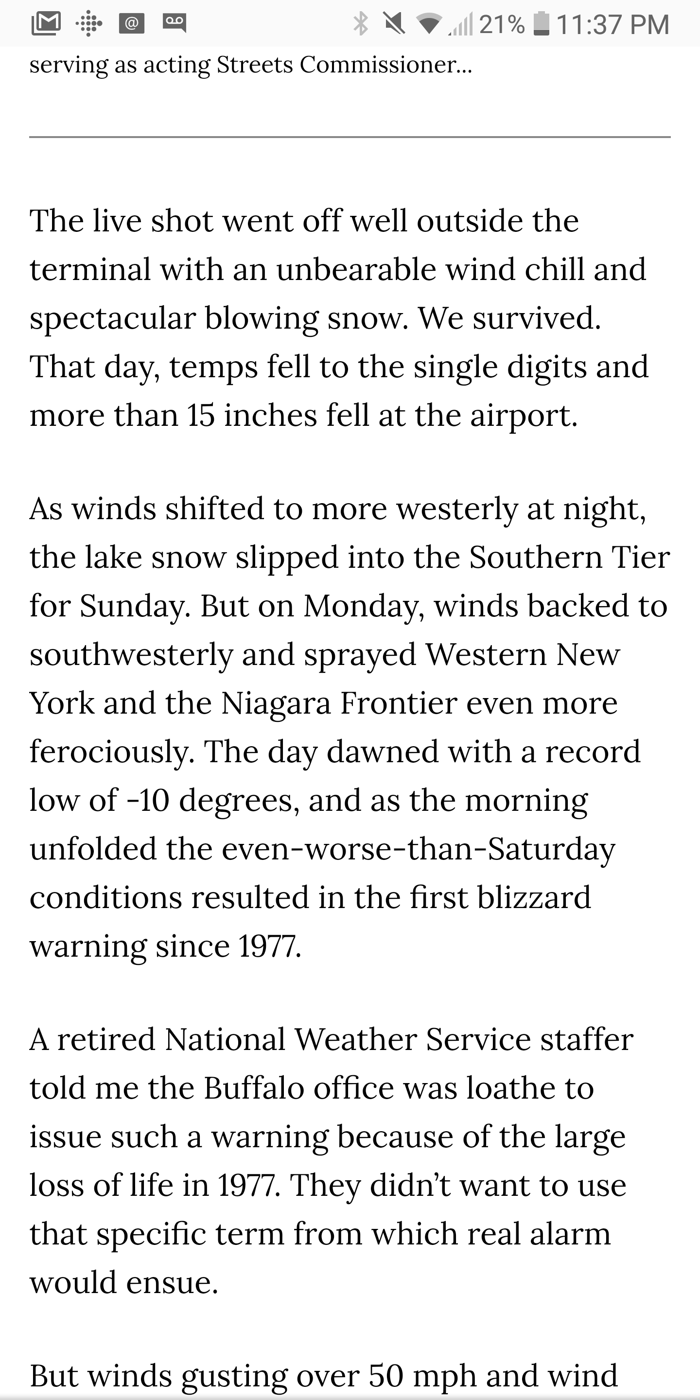
BW check this out...its an excerpt from Don Paul on the Blizzard of '85...check out those temps!!! How did snow flakes even form in cold air like that?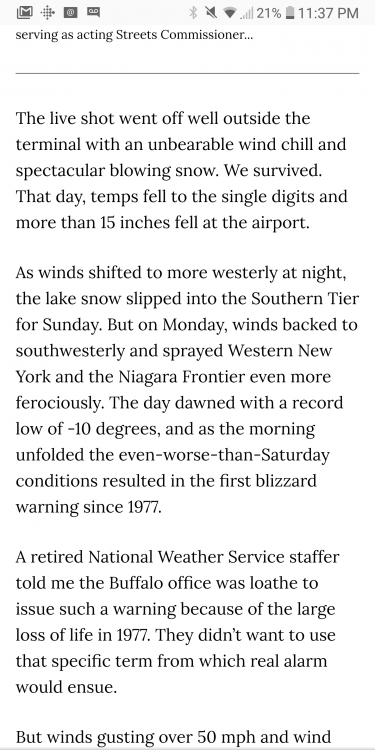
-
Upstate/Eastern New York
Thinksnow18 replied to BuffaloWeather's topic in Upstate New York/Pennsylvania
Can I like this 50 times?! I made mention of this earlier...hey look at some point history repeats or closely resembles itself so I'm going with like 1 in a million...so your saying there's a chance... -
Upstate/Eastern New York
Thinksnow18 replied to BuffaloWeather's topic in Upstate New York/Pennsylvania
There would be a week long west/SW flow in the median with that setup. Oddly it also lines up with the Blizzard of 85. -
Upstate/Eastern New York
Thinksnow18 replied to BuffaloWeather's topic in Upstate New York/Pennsylvania
I just reached for the AED... -
Upstate/Eastern New York
Thinksnow18 replied to BuffaloWeather's topic in Upstate New York/Pennsylvania
I saw that map and the 12z Goofus and I must admit I'm having a hard time concentrating on, well, anything at this moment -
Upstate/Eastern New York
Thinksnow18 replied to BuffaloWeather's topic in Upstate New York/Pennsylvania
Reminds me of the sabres a few years back...tanking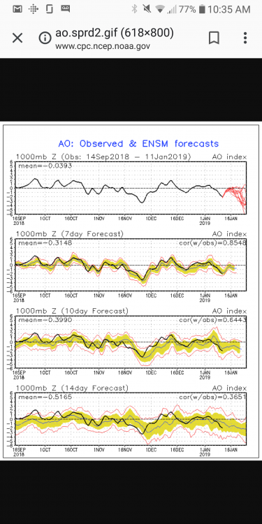
-
Upstate/Eastern New York
Thinksnow18 replied to BuffaloWeather's topic in Upstate New York/Pennsylvania
To piggyback off what you said and I'll add the BOOM!
-
Upstate/Eastern New York
Thinksnow18 replied to BuffaloWeather's topic in Upstate New York/Pennsylvania
That's at 10:1 ratios!!! If it's 15:1 which is more likely with the much colder weather that's been predicted, especially February, those totals will be between 40 and 50". Starting to resemble both Feb 2014 and 15. In fact I think KBUF in 15 had 48" that month. -
Upstate/Eastern New York
Thinksnow18 replied to BuffaloWeather's topic in Upstate New York/Pennsylvania
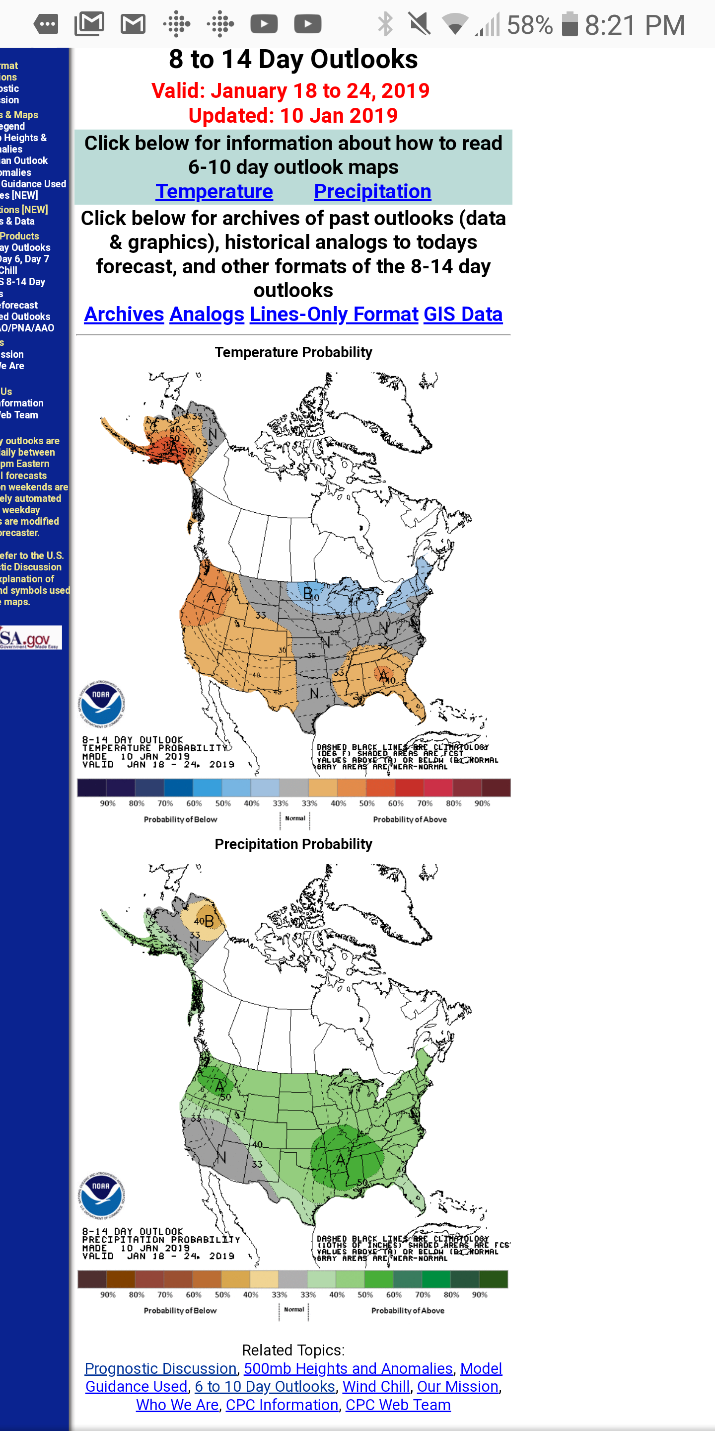
This map is remarkably different from yesterday in the same 8 to 14 outlook. Yesterday had AN Heights all the way to Michigan and almost on our doorstep, today that has been shoved far west. But what really has my attention is the amount of the conus with AN precip chances...BN temps AN precip...thats a recipe I like.
-
Upstate/Eastern New York
Thinksnow18 replied to BuffaloWeather's topic in Upstate New York/Pennsylvania
Was just going to post that!!! I think the models have finally caught up to the effects of THE SSWE that happened 2 weeks ago. Several chances for all. -
Upstate/Eastern New York
Thinksnow18 replied to BuffaloWeather's topic in Upstate New York/Pennsylvania
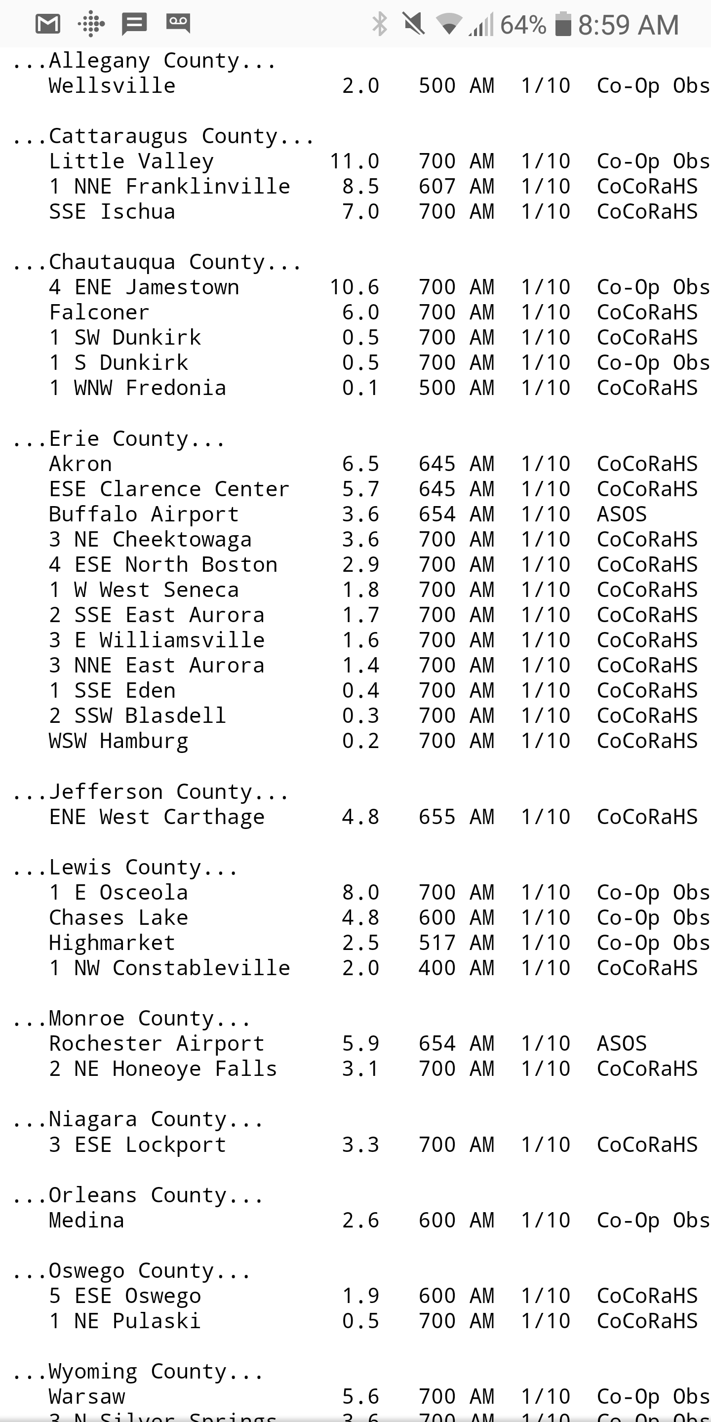
Seriously, someone's gotta explain the E Williamsville thing... -
Upstate/Eastern New York
Thinksnow18 replied to BuffaloWeather's topic in Upstate New York/Pennsylvania
Regardless of the exact number the area ski resorts needed this in a bad way...not to mention all the snowmobile trails across the state that might be able to open now. -
Upstate/Eastern New York
Thinksnow18 replied to BuffaloWeather's topic in Upstate New York/Pennsylvania
LMAO the spotter from E Williamsville might need to re-check their measurements, especially when the sites all around them are between 3 and 6 inches of snow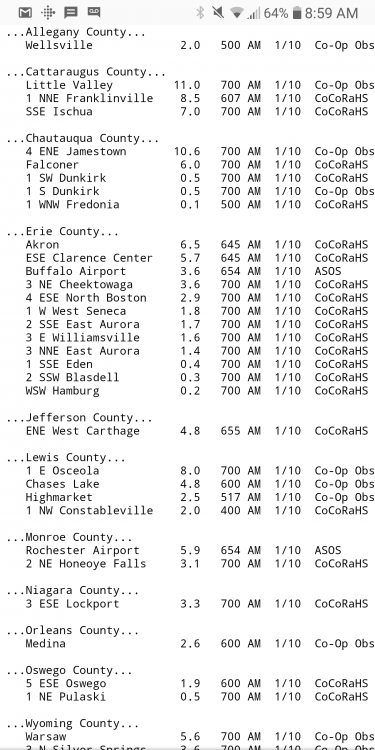
-
Upstate/Eastern New York
Thinksnow18 replied to BuffaloWeather's topic in Upstate New York/Pennsylvania
I'm kinda surprised to be honest. I remember as a kid that whenever we got NW winds it was eastern Niagara and Orleans counties that would jackpot. I almost feel nowadays we get quite a bit up north here now from Huron, Ontario and Georgian Bay. -
Upstate/Eastern New York
Thinksnow18 replied to BuffaloWeather's topic in Upstate New York/Pennsylvania
4.3" in Williamsville for the event, basically snow has stopped. I'll take it. -
Upstate/Eastern New York
Thinksnow18 replied to BuffaloWeather's topic in Upstate New York/Pennsylvania
No doubt whatever accumulates will be around for some time and with the 3 unicorn storms on the GFS and one on the euro it might actually resemble winter in Western and Central NY