Thinksnow18
-
Posts
4,144 -
Joined
-
Last visited
Content Type
Profiles
Blogs
Forums
American Weather
Media Demo
Store
Gallery
Everything posted by Thinksnow18
-
Upstate/Eastern New York
Thinksnow18 replied to BuffaloWeather's topic in Upstate New York/Pennsylvania
Long range not looking as promising this morning, as BW noted it will be marginally cold only and any precip could be rain or snow during that time. Hopefully this us just a few runs and we see better continuity as we near that timeframe. -
Upstate/Eastern New York
Thinksnow18 replied to BuffaloWeather's topic in Upstate New York/Pennsylvania
Nailed it. Dusting at best on the grass and the lake Erie band looks weak. On to the end of the month!!! -
Upstate/Eastern New York
Thinksnow18 replied to BuffaloWeather's topic in Upstate New York/Pennsylvania
In fact after next Monday it's cold, per GFS 18z, right through the end of the run and a couple opportunities. -
Upstate/Eastern New York
Thinksnow18 replied to BuffaloWeather's topic in Upstate New York/Pennsylvania
Yeah the potential is always there...lake effect, in my unprofessional opinion, is harder to nail down than the path of a hurricane. So there is always the "lake effect does what lake effect wants to" montra...still liking the end of November early December timeframe for an ec storm with retro LP. -
Upstate/Eastern New York
Thinksnow18 replied to BuffaloWeather's topic in Upstate New York/Pennsylvania
I honestly would not be shocked at a coating at best in northern Erie...ground is still relatively wet/not frozen couple with the band's movement means less than anticipated. Will probably have to wait until end of November early December for a big snow in the Niagara Frontier -
Upstate/Eastern New York
Thinksnow18 replied to BuffaloWeather's topic in Upstate New York/Pennsylvania
Impressive to me is the white Thanksgiving the majority of upstate New York will see. Sure we've had lake effect storms this time of year but those were localized...this is pretty significant that the area as a whole will share in this. Not very common. -
Upstate/Eastern New York
Thinksnow18 replied to BuffaloWeather's topic in Upstate New York/Pennsylvania
That bullseye is right over the metro northeast. -
Upstate/Eastern New York
Thinksnow18 replied to BuffaloWeather's topic in Upstate New York/Pennsylvania
Seriously starting to really imitate 76-77 -
Upstate/Eastern New York
Thinksnow18 replied to BuffaloWeather's topic in Upstate New York/Pennsylvania
Winter weather advisory for Erie, Chautauqua, cattaraugus, Genesee and Wyoming co's for tomorrow morning, 3-5" from tomorrow morning lake effect. -
Upstate/Eastern New York
Thinksnow18 replied to BuffaloWeather's topic in Upstate New York/Pennsylvania
This is a nice surprise...good to see we may score a decent amount before November ends after all!!! -
Upstate/Eastern New York
Thinksnow18 replied to BuffaloWeather's topic in Upstate New York/Pennsylvania
NWS AFD at 3:04pm has now mentioned what ceijka said this am and noon calling for 3-6" for metro during the early morning hours. -
Upstate/Eastern New York
Thinksnow18 replied to BuffaloWeather's topic in Upstate New York/Pennsylvania
Isn't supposed to get colder or do you mean very cold with retro low??? -
Upstate/Eastern New York
Thinksnow18 replied to BuffaloWeather's topic in Upstate New York/Pennsylvania
Funny thing is WIVB is talking heavy les in buffalo metro for a time Wednesday morning...the only ones showing or saying that -
Upstate/Eastern New York
Thinksnow18 replied to BuffaloWeather's topic in Upstate New York/Pennsylvania
That it was...i can't wait to see the temp anomalies for this month in not sure we had more than 4 AN temp days. -
Upstate/Eastern New York
Thinksnow18 replied to BuffaloWeather's topic in Upstate New York/Pennsylvania
The look after next weekends "warm-up" is cold but dry for the next 8 days heading into December. What we need, and when I mean we I mean buffalo, is a strong cutter to lift into the upper great Lakes and get stalled from moving east by blocking high pressure over Greenland so we can get a few days of wsw or SW vector winds. I agree with BW that while we will be cold more than our fair share of the winter getting moisture to line up during those times might prove difficult. -
Upstate/Eastern New York
Thinksnow18 replied to BuffaloWeather's topic in Upstate New York/Pennsylvania
Just roc??? What about all of WNY??? -
Upstate/Eastern New York
Thinksnow18 replied to BuffaloWeather's topic in Upstate New York/Pennsylvania
So that's kind of my point...it reminds me of 09-10 when we were frigid but dry because the storm track was off to our east (I think that's the year of all the big easy coast storms) and we were high and dry but frigid...save for that one odd NW flow event that clobbered Niagara Falls. -
Upstate/Eastern New York
Thinksnow18 replied to BuffaloWeather's topic in Upstate New York/Pennsylvania
Honest question...how does a tank AO and tank NAO with a ridge out west only get us to slightly BN temps? We're probably 6 or 7 bn for this month and we didn't have that set up at all. -
Upstate/Eastern New York
Thinksnow18 replied to BuffaloWeather's topic in Upstate New York/Pennsylvania
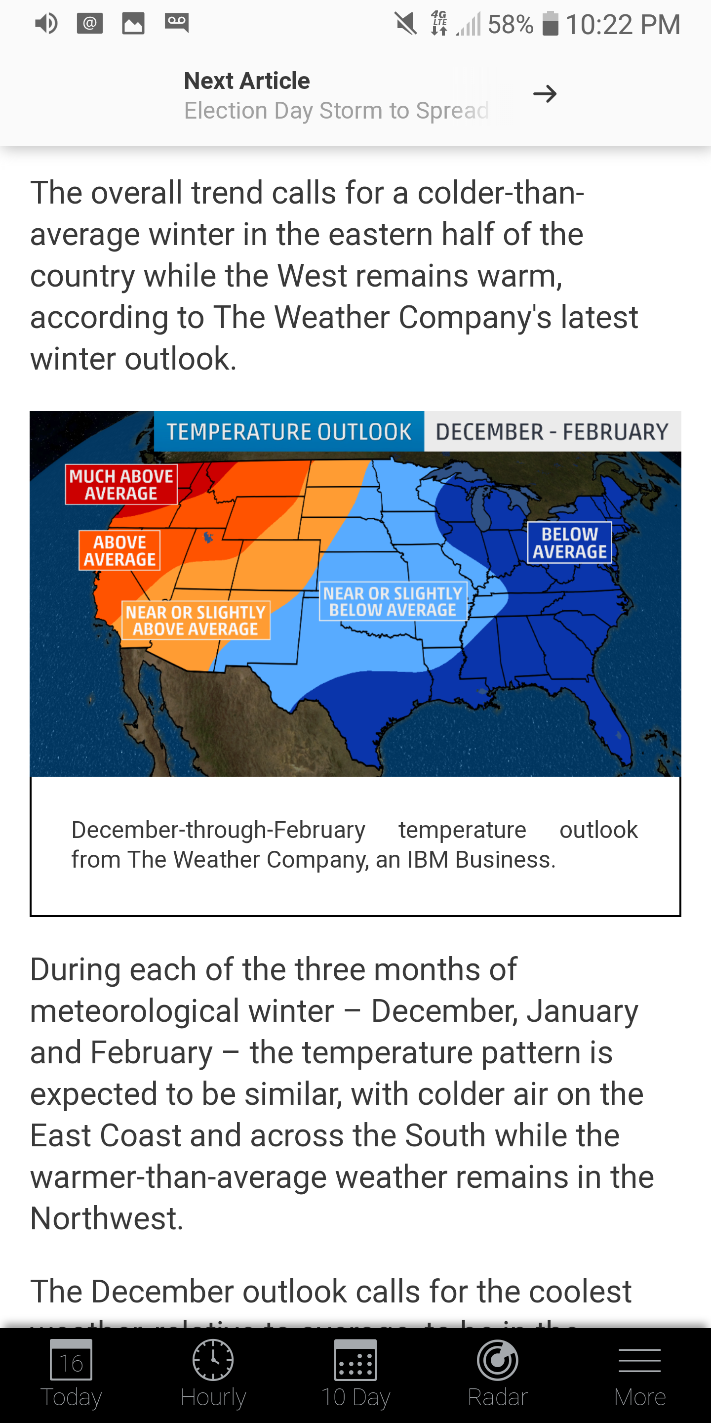
Too bad it's a weather channel map or it might be more impactful...however it is remarkably different from just 2 weeks ago so there's that...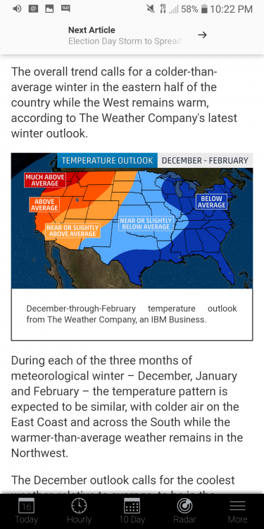
-
Upstate/Eastern New York
Thinksnow18 replied to BuffaloWeather's topic in Upstate New York/Pennsylvania
You think that's funny and I do get your humor you should check out what I'm sending next. -
Upstate/Eastern New York
Thinksnow18 replied to BuffaloWeather's topic in Upstate New York/Pennsylvania
Latest CPC for Dec: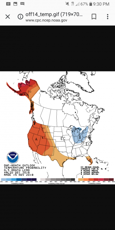
-
Upstate/Eastern New York
Thinksnow18 replied to BuffaloWeather's topic in Upstate New York/Pennsylvania
If by torch you mean mid 40's for Thanksgiving and the weekend after??? You're going to get your wish -
Upstate/Eastern New York
Thinksnow18 replied to BuffaloWeather's topic in Upstate New York/Pennsylvania
That was the very definition of pure paste. About 1" or 2" in Williamsville. In Lackawanna not much different...looking ahead a bit there has been a SW on the models that look to turn winds southwesterly Monday night into tuesday and we will be sufficiently cold enough for a lake response, of course still 4 days out and no clue if there will be enough moisture, or wind shear but from a distance at least the opportunity may be there. -
Upstate/Eastern New York
Thinksnow18 replied to BuffaloWeather's topic in Upstate New York/Pennsylvania
Grass. -
Upstate/Eastern New York
Thinksnow18 replied to BuffaloWeather's topic in Upstate New York/Pennsylvania
Lmao fair enough Kreskin...but Aayuud is right in saying that rain really wasn't in the cast...FWIW it is changing back to sleet am and snow in Williamsville.