Hotair
-
Posts
548 -
Joined
-
Last visited
Content Type
Profiles
Blogs
Forums
American Weather
Media Demo
Store
Gallery
Everything posted by Hotair
-
13 named storms with Martin as of today the score is 13-5-2 but who’s counting ? LoL
-
Fingers crossed
-
Death toll confirmed stands at 15 now
-
Just saw drone video footage of homes in both Sanibel and in Cape Coral. A surprising number of homes look intact. A testament to the Florida building codes. As for water damage from surge flooding that’s a different story altogether.
-
EVery now and then you see a home that is completely obliterated. Is this due to construction type? or did we happen to have small tornadoes spawning in the area on top of the wind and surge ?
-
Everyone is in on it. When you can get flood insurance in a high risk area in Florida for half of what it costs in say Connecticut, people build knowing their investment is more or less secure through tax payer subsidies surge is now forecast along the entire East coast
-
You are correct. I shouldn’t have said underwater. They’ve been crushed with high winds but the storm surge is not what fort Myers is experiencing edit: this is the video I had based my statement on. It claimed to be from punta gorda https://twitter.com/YaCelacanto/status/1575247806889136143?s=20&t=10p9wRsEoX2GAPuBpEq5IQ
-
Punta Gorda was destroyed by Charley in 2004. It is all brand new construction to latest building codes but seems it’s now under water. It’s gonna take a lot of flood insurance money to get those residents rebuilding yet again
-
I left my home in South Tampa and evacuated to Lakeland. The cam videos of my home do not show more than gusty wind and light rain all afternoon. no flooding.
-
Ian took a wobble East on radar that should help keep the strongest winds away from the coastal areas North of Port Charlotte (Sarasota and places North of it). Tampa Bay sure dodged a bullet with Ian
-
My friend works Florida emergency services. He texted that many calls have come in about pets left in houses whose webcams show have taken on water. These get put on a lower priority rescue list behind people. It is heartbreaking that so many people evacuated but left their pets behind
-
Yikes. Hopefully they’ve let their 911 hotline know they need assistance as soon as available. Katrina survivors were able to get in their attic and then bust through with hammers axe or whatever and climb above when winds died down
-
Quote Tweet IEMBot TBW @iembot_tbw · 17m Automated At 4:27 PM EDT, 3 SE Cape Coral [Lee Co, FL] MESONET reports HURRICANE. CAPE CORAL YACHT CLUB WEATHERSTEM REPORTS 112MPH GUST TO 135MPH. https://mesonet.agron.iastate.edu/lsr/#TBW/202209282027/202209282027
-
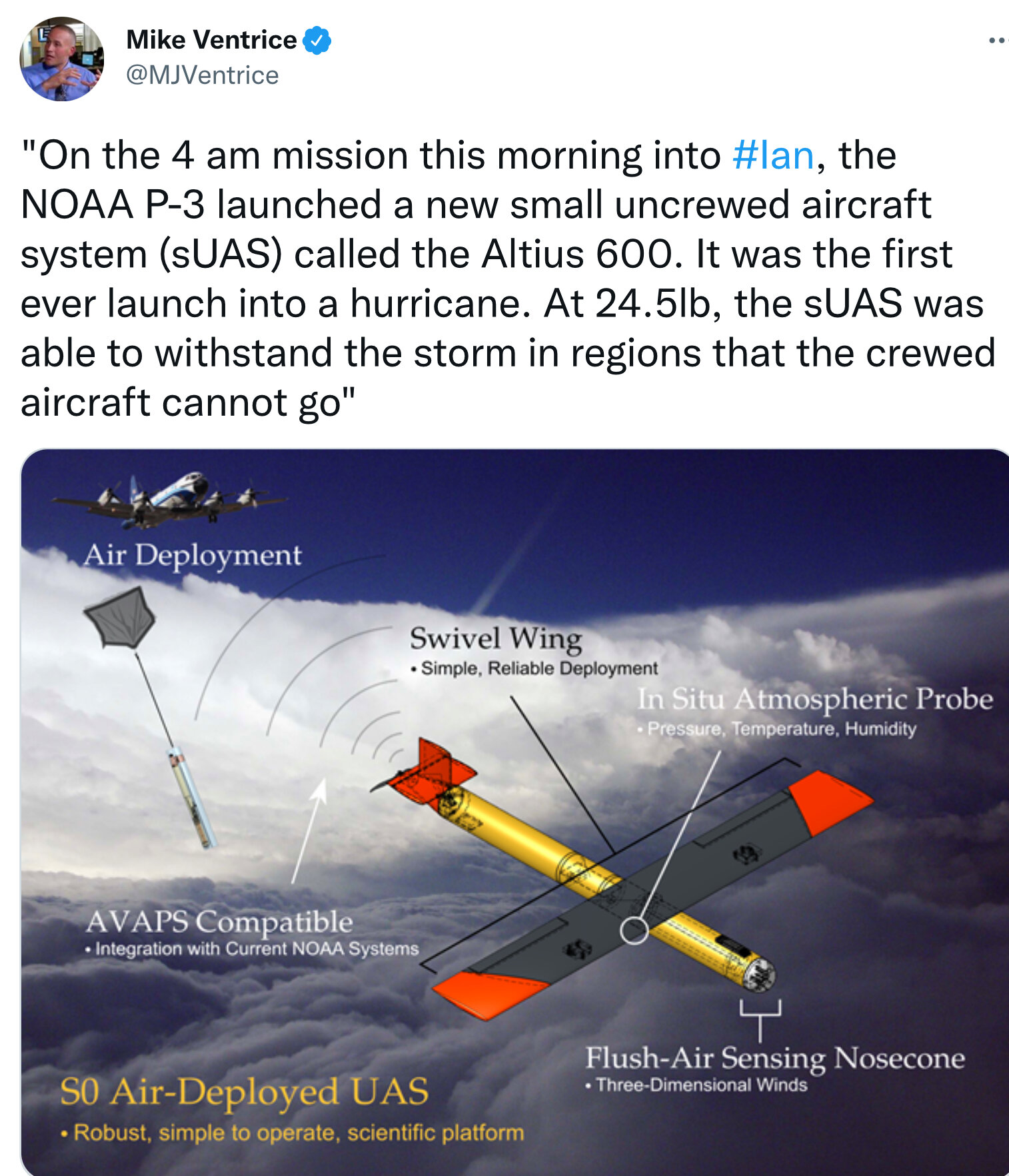
The future of hurricane recon will likely be mostly via drone. No reason to put lives at risk to collect hurricane vitals and track

-
I had neighbors who move there but we lost touch over the years. I’m hoping they were smart enough to leave ahead of the storm
-
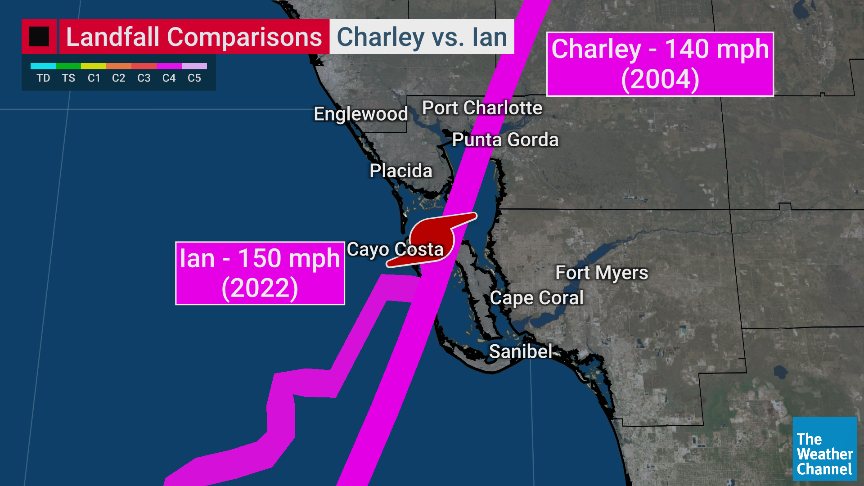
Quite remarkable how similar Charley and Ian’s LF turned out
-
Anyone else concerned that we have seen almost zero footage last few hours from anyone in Cape Coral?
-
The combination of 150 mph winds, storm surge and the fact Ian is taking it’s sweet time sightseeing at 9 mph means the people along the track will be sitting in 5+ hours of hurricane strength winds. Loss of life is unfortunately a high possibility with this one, especially given the older population and stubbornness against evacuation.
-
I’m seeing lots of flooded cars as far South as Naples!, the used car market in SW Florida will be totally bonkers next few months.
-
If I’m right, the peak storm surge in the area of LF is still yet to come when the SW eyewall starts coming on shore
-
Quote Tweet Dave Malkoff @malkoff · 34m Crazy #HurricaneHunt ! Our @USAFReserve 53rd Weather Reconnaissance Squadron just landed. We hit hail, massive turbulence in the eye wall that dropped us 1000+ feet and saw #hurricaneIan rapidly intensity. It was NOT even calm inside the eye. edit: they suffered some damage to their plane in the storm
-
Eric Webb @webberweather A recent dropsonde into the western semi-circle of Ian’s eyewall has generally confirmed these 166 kt (190 mph) winds measured by the TDR earlier this morning Wow.
-
The go bag is to take with them when national guard rescues them.
-
Could they just be delaying a bit ?
-
Recon has found a central pressure of 933.1 mb, so Ian continues to flex and is still deepening folks near Ft Myers better hope the cane stays on the water longer and comes in North of them.