Hotair
-
Posts
548 -
Joined
-
Last visited
Content Type
Profiles
Blogs
Forums
American Weather
Media Demo
Store
Gallery
Everything posted by Hotair
-
Major Hurricane Melissa - 892mb - 185mph Jamaica landfall
Hotair replied to GaWx's topic in Tropical Headquarters
And add to the fact that this isn’t a large country with thousands of roofing companies willing to travel to a disaster area. The workforce there is limited as are the tools (cranes, materials, etc). Many of those places will not be rebuilt for at least 3 years or longer. Now also consider that the percentage of homes covered by insurance in Jamaica is roughly under 5%. -
Major Hurricane Melissa - 892mb - 185mph Jamaica landfall
Hotair replied to GaWx's topic in Tropical Headquarters
I’ll take the image down. But appears they lost their roof again this time around based on the Antigua reporting I linked -
Major Hurricane Melissa - 892mb - 185mph Jamaica landfall
Hotair replied to GaWx's topic in Tropical Headquarters
The video is here https://antigua.news/2025/10/28/jamaica-black-river-hospital-suffers-devastating-damage-from-hurricane-melissa/ -
Major Hurricane Melissa - 892mb - 185mph Jamaica landfall
Hotair replied to GaWx's topic in Tropical Headquarters
Pinpoint eye and significant Lightning visible in this image capture. Just a monster of a storm.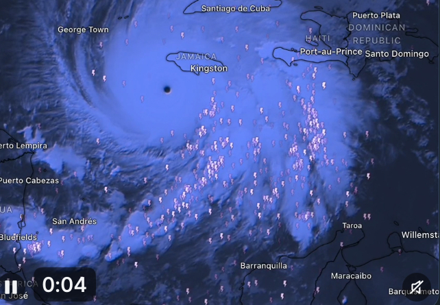
-
Major Hurricane Melissa - 892mb - 185mph Jamaica landfall
Hotair replied to GaWx's topic in Tropical Headquarters
Flooding in Kingston already via this sat image from Copernicus
-
Major Hurricane Melissa - 892mb - 185mph Jamaica landfall
Hotair replied to GaWx's topic in Tropical Headquarters
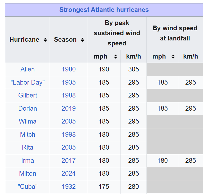
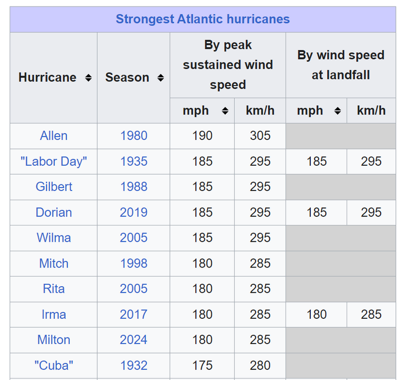
Footage of flooding coming in from Dominican Republic this morning is bad enough. Can’t imagine what people of Haiti are going through. However all of Jamaica better seek shelter higher up cause the coastline is about to get decimated. This one reminds me of Wilma as a late storm cat 5, but even that made landfall in Mexico as only a 4. this may well be the most powerful storm to hit the island of Jamaica in recorded history. To put it in perspective 45 deaths were attributed to Gilbert back in ‘88 and that was a C3. -
I am reading in the News today that DOGE has entered NOAA headquarters and will be looking to downsize it. Any ideas on what this could mean? I was understanding that NOAA was making do with limited budgets that had not kept up with inflation. restricting NOAAs ability to report on climate change and do advanced modeling and reporting of storm threats would be disastrous in my opinion.
-
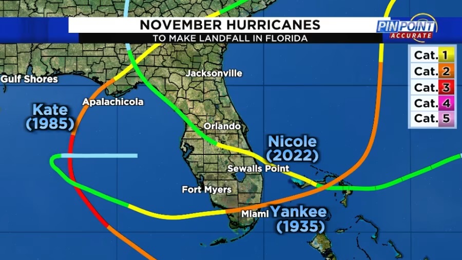
That euro is not great news for the FL southwest coast. we have only ever had 3 canes come into Florida in November this would be the 4th in history.
-
Agree but if it’s a congressional representative or ex president suggesting this and who apparently pretends to have access to this info, then it is incumbent on them to show their evidence or else stfu.
-
US Mets face death threats after hurricane Milton, Helene misinformation people are nuts and to think we share this world with them. https://www.theguardian.com/us-news/2024/oct/11/meteorologists-death-threats-hurricane-conspiracies-misinformation
-
I’m certain it will. Just thankful it’s not an issue for most in Tampa Bay as had been widely feared. The concern over extreme record winds and record surge in TB just did not materialize.
-
@EngagewithErin Tampa Bay water levels to swing wildly as Milton passes. While it appears that Tampa Bay will avoid the record surge feared if Milton passed north or directly into the bay, the proximity of Milton’s core will still significant change the bay’s water levels. Strong winds blowing offshore will likely lead to “reverse surge” – or extremely low water levels as the winds blow water out of the bay and into the ocean until the storm passes late tonight. But after the eye of the storm passes south of Tampa overnight, the winds over the Bay will change direction and start to blow from a more westerly direction. This will occur as the tide is also rising ahead of the normal high tide around 6 a.m ET. Water levels are projected to rise 6 feet in 6 hours on Thursday morning, according to NOAA forecasts. At this time, water levels are not expected to reach the heights observed in Hurricane Helene two weeks ago.
-
Electric power holding up along most of the Tampa Bay Area for now. Surge not an issue for now. Extreme rain will result in localized fresh water flooding in the usual areas.
-
I hope so. Given all possible outcomes just three days ago this seem like a win Tornado events are still in play so we must stay vigilant
-
Tampa dodged a major bullet if that track confirms.
-
Helene flooded homes but left the structures mostly intact in many coastal areas. After what I saw today on the roads in St Pete ( and despite our Governor celebrating a few hundred dump trips.) there is so much debris still piled everywhere that even a cat 2 wind will send deadly and destructive items flying everywhere. If this storm stays on steroids, there won’t be an uncovered window left intact after the storm
-
I can’t remember any storms going sub 910 mb twice in their evolution
-
With each passing hour that landfall window becomes more and more locked in.
-
I don’t believe I have ever anticipated a recon mission’s results with both more excitement and fear. And we are talking many hundreds of past Atlantic canes here. This is peak americanwx.com for me right here
-
Is Milton the strongest GOM cane ever recorded ? tied for third strongest Atlantic cane
-
Denis Phillips @DenisPhillipsWx Mandatory evacuation orders for Hillsborough county zones A & B along with all manufactured/mobile housing beginning today at 2:30pm.
-
looks like A,B and C are all being evacuated before the storm’s arrival 1:45 p.m. Pinellas orders evacuations for health care facilities Pinellas County issued a mandatory evacuation order for long-term care health facilities, assisted living facilities and hospitals in evacuation zones, A, B and C. The evacuation includes six hospitals, 25 nursing homes and 44 assisted living facilities totaling approximately 6,600 patients. https://www.tampabay.com/hurricane/2024/10/06/tropical-storm-milton-live-updates-tampa-bay-hillsborough-pinellas-pasco/
-
Making a bad situation much worse, officials in Tampa Bay Area are now conceding that cleanup of Helene debris by the time this storm approaches the area is an impossible task. With Milton bearing down, about 5% of the debris from Hurricane Helene had been cleared from Clearwater Beach, Clearwater Mayor Bruce Rector said at a news conference Sunday. “My phone has been ringing off the hook the last two days with residents concerned about the debris,” Rector said. The mayor said he was coordinating with officials from the local level to the White House. But clearing off the entire island before a midweek landfall will likely be impossible, Rector said. “We’re in a desperate situation to move as much as we can as quickly as we can,” he said.
-
000 WTNT34 KNHC 061748 TCPAT4 BULLETIN Hurricane Milton Intermediate Advisory Number 5A NWS National Hurricane Center Miami FL AL142024 100 PM CDT Sun Oct 06 2024 ...AIR FORCE HURRICANE HUNTERS FIND MILTON RAPIDLY INTENSIFYING INTO A HURRICANE... SUMMARY OF 100 PM CDT...1800 UTC...INFORMATION ---------------------------------------------- LOCATION...22.5N 94.0W ABOUT 290 MI...465 KM WNW OF PROGRESO MEXICO ABOUT 815 MI...1310 KM WSW OF TAMPA FLORIDA MAXIMUM SUSTAINED WINDS...80 MPH...130 KM/H PRESENT MOVEMENT...E OR 100 DEGREES AT 6 MPH...9 KM/H MINIMUM CENTRAL PRESSURE...988 MB...29.18 INCHES WATCHES AND WARNINGS -------------------- CHANGES WITH THIS ADVISORY: None. SUMMARY OF WATCHES AND WARNINGS IN EFFECT: A Tropical Storm Warning is in effect for... * Celestun to Cabo Catoche A Tropical Storm Watch is in effect for... * East of Cabo Catoche to Cancun A Tropical Storm Warning means that tropical storm conditions are expected somewhere within the warning area within 36 hours. A Tropical Storm Watch means that tropical storm conditions are possible within the watch area, generally within 48 hours. Interests in the remainder of the Yucatan peninsula of Mexico, the Florida Peninsula, the Florida Keys, and the northwestern Bahamas should monitor the progress of this system. Hurricane and Storm Surge Watches could be required for portions of Florida late today. For storm information specific to your area, please monitor products issued by your national meteorological service. DISCUSSION AND OUTLOOK ---------------------- At 100 PM CDT (1800 UTC), the center of Hurricane Milton was located by an Air Force Reserve Hurricane Hunter aircraft near latitude 22.5 North, longitude 94.0 West. Milton is moving toward the east near 6 mph (9 km/h), and this general motion is expected today. An eastward to east-northeastward motion is forecast on Monday, followed by a faster northeastward motion on Tuesday and Wednesday. On the forecast track, Milton is forecast to move north of the Yucatan Peninsula and to move across the Gulf of Mexico and approach the west coast of the Florida Peninsula by midweek. Maximum sustained winds have increased to near 80 mph (130 km/h) with higher gusts. Milton is forecast to rapidly intensify during the next couple of days and become a major hurricane on Monday. Hurricane-force winds extend outward up to 20 miles (30 km) from the center and tropical-storm-force winds extend outward up to 80 miles (130 km) from the center. The estimated minimum central pressure is 988 mb (29.18 inches) based on Air Force dropsonde data. HAZARDS AFFECTING LAND ---------------------- Key Messages for Hurricane Milton can be found in the Tropical Cyclone Discussion under AWIPS header MIATCDAT4 and WMO header WTNT44 KNHC and on the web at hurricanes.gov/text/MIATCDAT4.shtml RAINFALL: Rainfall amounts of 5 to 8 inches, with localized totals up to 12 inches, are expected across portions of the Florida Peninsula and the Keys through Wednesday night. This rainfall brings the risk of locally considerable flash, urban, and areal flooding, along with widespread minor to moderate river flooding with major flooding possible. Milton will also produce rainfall totals of 2 to 4 inches across portions of the northern Yucatan Peninsula. For a complete depiction of forecast rainfall associated with Hurricane Milton, please see the National Weather Service Storm Total Rainfall Graphic, available at hurricanes.gov/graphics_at4.shtml?rainqpf and the Flash Flood Risk graphic at hurricanes.gov/graphics_at4.shtml?ero. WIND: Tropical storm conditions are expected in the Tropical Storm Warning area in the Yucatan Peninsula Monday night and Tuesday and possible in the watch area on Tuesday. SURF: Swells generated by the system are affecting the coast of the southwestern Gulf of Mexico today. These swells are expected to spread northward and eastward along much of the Gulf Coast by early next week, and could cause life-threatening surf and rip current conditions. Minor coastal flooding could also occur along the northern coast of the Yucatan Peninsula from large swells. Please consult products from your local weather office. NEXT ADVISORY ------------- Next complete advisory at 400 PM CDT. $$ Forecaster Blake