Hotair
-
Posts
548 -
Joined
-
Last visited
Content Type
Profiles
Blogs
Forums
American Weather
Media Demo
Store
Gallery
Everything posted by Hotair
-
Recon data since these models first initialized shows storm moved further to the North than forecasted. I suspect the more western models will continue to creep eastwardly as new runs kick off.
-
Noru in the Pacific just experienced a 50 mph to 155 mph RI over 24 hours in similar temperature waters. Let’s hope Ian is not trying to one up that storm.
-
My Tampa community leaders just got the news that the hurricane might come in this direction so I am seeing lots of text alerts urging citizens in low lying areas to evacuate.. I suspect much of this will fall on deaf ears. It’s a nice day out and people are more focused on the Bucs game
-
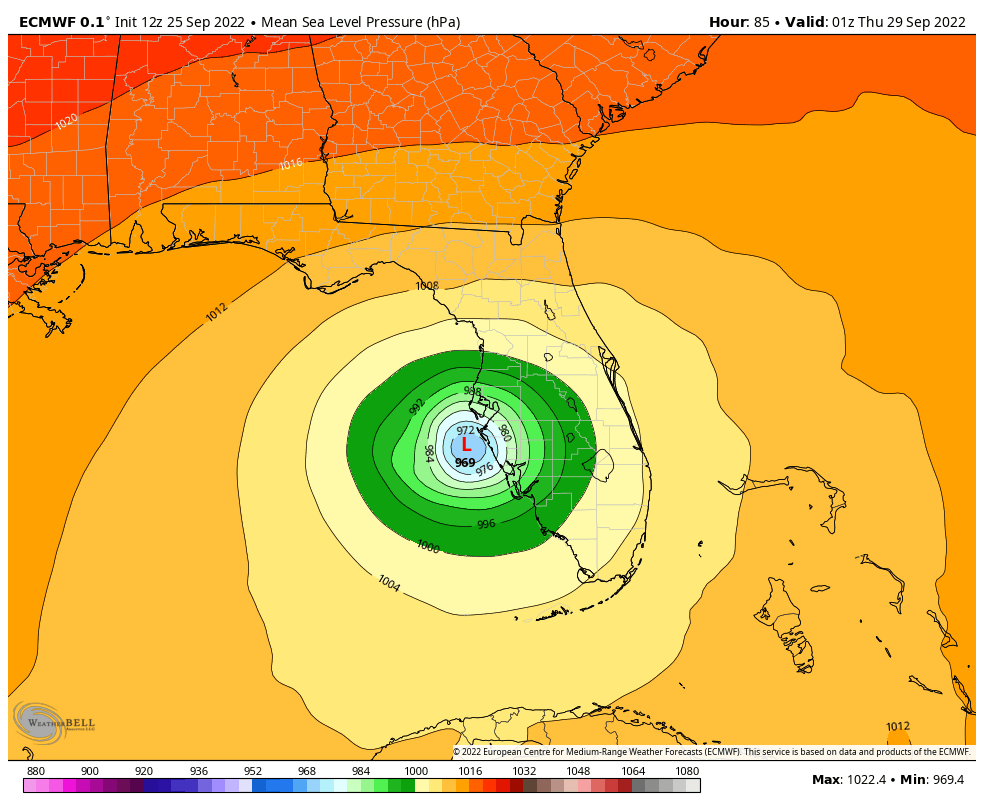
Crap! Euro really wants to end Tampa’s streak of cane free seasons. my South Tampa home will be under water if Ian does anything remotely like this model insists on.
-
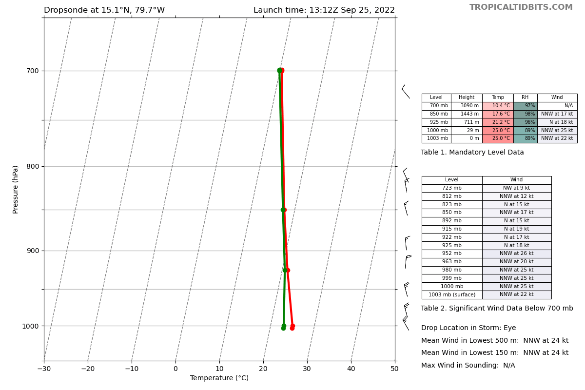
Perhaps soon we can see some RI motivation. From @WxAtom The most recent passes from both our recon planes (at 925mb and 700mb in pressure) seem to suggest Tropical Storm Ian has properly stacked it’s centers.
-
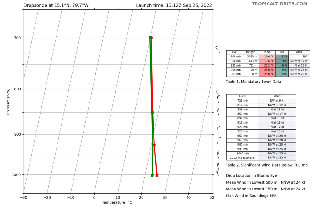
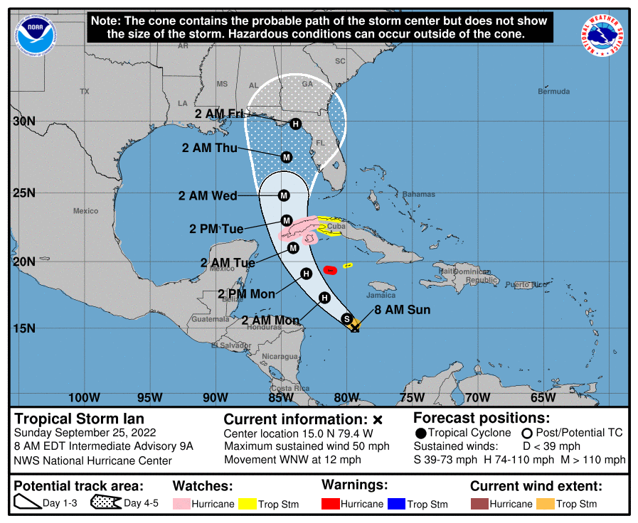
Given the large uncertainty in LF track it appears many Florida coastal communities (in South and Southwest) are choosing to delay preparations. Residents there are not getting too focused yet on securing their property/ getting storm ready. I hope this does not mean that by the time the LF track is locked in to a few counties we have inclement weather upon us that discourages those folks from evacuating and getting the supplies they will need to mitigate flooding/wind damage and loss of utilities etc. latest recon fix for Ian: New recon fix for AF301 0909A IAN @ 2022-09-25 13:16:00 UTC: Lat/Lon 15.06,-79.66, MSLP 1005 mb
-
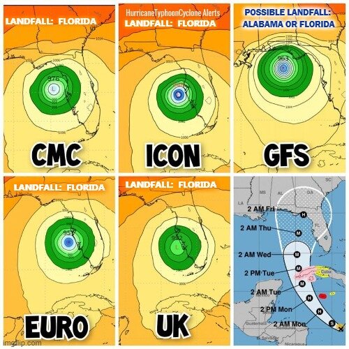
Here are the contenders and LF options. East and South result in stronger storms due to less time in dry air Personally I would love to see Ian run into the Gulf and then LF as a TS somewhere near AL
-
8 am
-
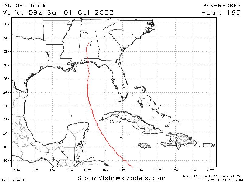
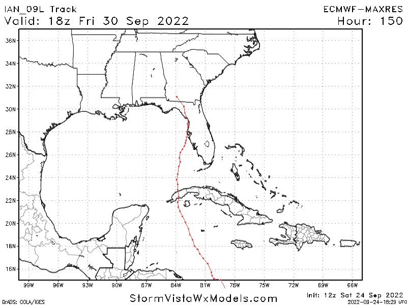
Interesting that despite the immense resources being dedicated to forecasting this storm, we have our two best models showing a near 200 mile difference in path just after 3 days away. its almost as good as simply having an experienced meteorologist eyeball it and make a guesstimate with a sharpee at this time.
-
-
Cat 4 intensity would be absolutely brutal anywhere along Florida West coast
-
000 WTNT44 KNHC 242056 TCDAT4 Tropical Storm Ian Discussion Number 7 NWS National Hurricane Center Miami FL AL092022 500 PM EDT Sat Sep 24 2022 The satellite presentation of Ian has improved this afternoon. The associated deep convection shows increased signs of organization, and the deep-layer shear appears to have diminished over the cyclone based on more extensive upper-level outflow noted in visible satellite imagery. An Air Force Hurricane Hunter aircraft found 850-mb peak flight level winds of 44 kt and several SFMR retrievals greater than 40 kt, while dropsonde data suggest the minimum pressure has not changed much since the previous flight. A blend of these data support an initial intensity of 40 kt for this advisory. The aircraft data suggest the center could be re-forming slightly west of previous estimates, so the initial motion is an uncertain 265/14 kt. Ian is expected to move westward through early Sunday before turning northwestward around the southwestern periphery of a ridge to the north. A north-northwestward to northward motion is forecast on Monday and Tuesday as the center of Ian passes near or over the western tip of Cuba and emerges over the southeastern Gulf of Mexico. Overall, the westward trend in the track models continues, with the latest GFS on the far left side of the guidance envelope and the ECMWF on the right edge. The track forecast is still highly uncertain at days 4-5, with the GFS and ECMWF positions about 200 n mi apart by 96 h. There is significant spread noted even among the GFS ensemble members, with positions that range from the north-central Gulf of Mexico to the west coast of Florida. Hopefully, data collected from special radiosonde releases and a NOAA G-IV flight this evening will help better resolve the steering flow around Ian and the deep-layer trough that is forecast to be over the eastern U.S. early next week. The latest NHC track forecast is once again adjusted westward, and further adjustments may be needed given the increased uncertainty in the day 3-5 period. Ian is expected to significantly strengthen over the next few days as it moves within a low shear environment over SSTs greater than 30 deg C in the northwestern Caribbean Sea. As the structure of the cyclone continues to improve and Ian develops an inner core, rapid intensification (RI) appears very likely. The SHIPS-RII probabilities continue to highlight this potential, with a 66 percent chance of a 65-kt intensity increase in 72 h. The NHC intensity forecast has been raised substantially through 96 h, and it now shows Ian reaching major hurricane strength by late Monday before it nears western Cuba. These changes closely follow the IVCN and HCCA consensus aids, although there remains guidance even higher than the current forecast. Ian is forecast to remain a major hurricane as it moves northward across the eastern Gulf of Mexico and approaches Florida. Environmental conditions could become less favorable late in the period due to southerly shear associated with the aforementioned trough, but Ian is expected to remain a large and powerful hurricane through the period. Key Messages: 1. Ian is expected to produce heavy rainfall, flash flooding, and possible mudslides in areas of higher terrain, particularly over Jamaica and Cuba. Limited flash and urban flooding is possible with rainfall across the Florida Keys and Florida peninsula through mid next week. 2. Hurricane or tropical storm conditions are expected on Grand Cayman beginning early Monday. 3. Ian is forecast to be a major hurricane when it passes near or over western Cuba, and there is increasing confidence in a life-threatening storm surge and hurricane-force winds in portions of western Cuba beginning late Monday. 4. Ian is expected to remain a major hurricane when it moves generally northward across the eastern Gulf of Mexico during the middle of next week, but uncertainty in the track forecast is higher than usual. Regardless of Ian’s exact track, there is a risk of dangerous storm surge, hurricane-force winds, and heavy rainfall along the west coast of Florida and the Florida Panhandle by the middle of next week, and residents in Florida should ensure they have their hurricane plan in place, follow any advice given by local officials, and closely monitor updates to the forecast. FORECAST POSITIONS AND MAX WINDS INIT 24/2100Z 14.3N 77.0W 40 KT 45 MPH 12H 25/0600Z 14.6N 78.4W 50 KT 60 MPH 24H 25/1800Z 15.7N 80.3W 60 KT 70 MPH 36H 26/0600Z 17.4N 82.2W 75 KT 85 MPH 48H 26/1800Z 19.2N 83.5W 95 KT 110 MPH 60H 27/0600Z 20.9N 84.4W 110 KT 125 MPH 72H 27/1800Z 23.1N 85.0W 115 KT 130 MPH 96H 28/1800Z 26.2N 84.8W 115 KT 130 MPH 120H 29/1800Z 28.7N 83.9W 90 KT 105 MPH $$ Forecaster Reinhart
-
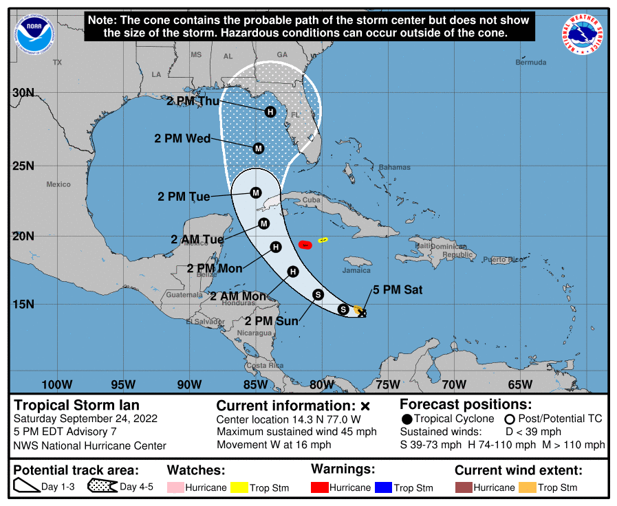
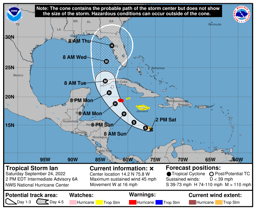
606 WTNT34 KNHC 241752 TCPAT4 BULLETIN Tropical Storm Ian Intermediate Advisory Number 6A NWS National Hurricane Center Miami FL AL092022 200 PM EDT Sat Sep 24 2022 ...IAN EXPECTED TO RAPIDLY STRENGTHEN LATER THIS WEEKEND... SUMMARY OF 200 PM EDT...1800 UTC...INFORMATION ---------------------------------------------- LOCATION...14.2N 75.8W ABOUT 270 MI...435 KM SSE OF KINGSTON JAMAICA ABOUT 505 MI...810 KM SE OF GRAND CAYMAN MAXIMUM SUSTAINED WINDS...45 MPH...75 KM/H PRESENT MOVEMENT...W OR 260 DEGREES AT 16 MPH...26 KM/H MINIMUM CENTRAL PRESSURE...1003 MB...29.62 INCHES WATCHES AND WARNINGS -------------------- CHANGES WITH THIS ADVISORY: The government of the Cayman Islands has upgraded the Hurricane Watch to a Hurricane Warning for Grand Cayman, and has changed the Hurricane Watch to a Tropical Storm Watch for Little Cayman and Cayman Brac. SUMMARY OF WATCHES AND WARNINGS IN EFFECT: A Hurricane Warning is in effect for... * Grand Cayman A Tropical Storm Watch is in effect for... * Jamaica * Little Cayman and Cayman Brac A Hurricane Warning means that hurricane conditions are expected somewhere within the warning area. A warning is typically issued 36 hours before the anticipated first occurrence of tropical-storm-force winds, conditions that make outside preparations difficult or dangerous. Preparations to protect life and property should be rushed to completion. A Tropical Storm Watch means that tropical storm conditions are possible within the watch area, generally within 48 hours. Interests in western and central Cuba, the Florida Keys, and the Florida peninsula should monitor the progress of Ian. For storm information specific to your area, please monitor products issued by your national meteorological service. DISCUSSION AND OUTLOOK ---------------------- At 200 PM EDT (1800 UTC), the center of Tropical Storm Ian was located near latitude 14.2 North, longitude 75.8 West. Ian is moving toward the west near 16 mph (26 km/h), and this general motion is expected to continue through tonight. A turn toward the northwest is forecast on Sunday, followed by a north-northwestward turn on Monday and a northward motion on Tuesday. On the forecast track, the center of Ian is forecast to pass southwest of Jamaica on Sunday, and pass near the Cayman Islands Sunday night and early Monday. Ian will then approach western Cuba late Monday and emerge over the southeastern Gulf of Mexico on Tuesday. Maximum sustained winds remain near 45 mph (75 km/h) with higher gusts. Significant strengthening is forecast during the next few days. Ian is expected to become a hurricane late Sunday or Sunday night and could be at or near major hurricane strength late Monday when it approaches western Cuba. Tropical-storm-force winds extend outward up to 60 miles (95 km) from the center. The estimated minimum central pressure is 1003 mb (29.62 inches). HAZARDS AFFECTING LAND ---------------------- Key messages for Ian can be found in the Tropical Cyclone Discussion under AWIPS header MIATCDAT4 and WMO header WTNT44 KNHC and on the web at hurricanes.gov/text/MIATCDAT4.shtml. WIND: Hurricane conditions are expected to reach Grand Cayman by early Monday, with tropical storm conditions expected by Sunday night. Tropical storm conditions are possible on Jamaica by Sunday, and on Little Cayman and Cayman Brac by Sunday night. RAINFALL: Ian is expected to produce the following rainfall: Southern Haiti and southern Dominican Republic: 2 to 4 inches, with local maxima up to 6 inches Jamaica and the Cayman Islands: 4 to 8 inches, with local maxima up to 12 inches Western to central Cuba: 6 to 10 inches, with local maxima up to 14 inches Florida Keys and south Florida: 1 to 3 inches, with local maxima up to 5 inches through Tuesday morning These rains may produce flash flooding and mudslides in areas of higher terrain, particularly over Jamaica and Cuba. Flash and urban flooding is possible with rainfall across the Florida Keys and the Florida peninsula through mid next week. Additional flooding and rises on area streams and rivers across Florida cannot be ruled out through next week given already saturated antecedent conditions. STORM SURGE: Storm surge could raise water levels by as much as 2 to 4 feet above normal tide levels along the immediate coast in areas of onshore winds in the Cayman Islands Sunday night into Monday. Localized coastal flooding is possible along the coast of Jamaica in areas of onshore winds on Sunday. SURF: Swells generated by Ian will begin affecting Jamaica and the Cayman Islands on Sunday and spread westward to Cuba by Monday. These swells are likely to cause life-threatening surf and rip current conditions. Please consult products from your local weather office. NEXT ADVISORY ------------- Next complete advisory at 500 PM EDT. $$ Forecaster Reinhart
-
TAMPA FL: City of Tampa is offering sandbags daily from 9AM-6PM starting tomorrow 9/25 at Himes Ave Complex, Al Barnes Park & MacFarlane Park. Please bring proof of City of Tampa residence. Limit of 10 bags.
-
TEAL 72 is now headed back to base. The NOAA G-IV is currently conducting a synoptic surveillance flight ahead of Ian. NOAA 43 is next on deck. They are scheduled to depart shortly at 5 pm EDT / 2100 UTC. This looks to be a 24/7 operation from here on out.
-
Northern blob wining the LLC battle should push models to start prodding the storm East vs West. I would expect GFS will start reflecting this more once it is seeded with todays recon data edit: as far as 5 pm track cone guidance is concerned, if I were to play NHC for a moment, I’d lean toward leaving the cone pretty much where it was at 2 pm.
-
According to @MeteoAtlas Recon has finally investigated Ian’s mid-level centre and has found that a new LLC has been drilled down there. Ian can now stack itself in a nuclear environment and start strengthening and organising. Could be in for some extremely fast intensification rates.

-
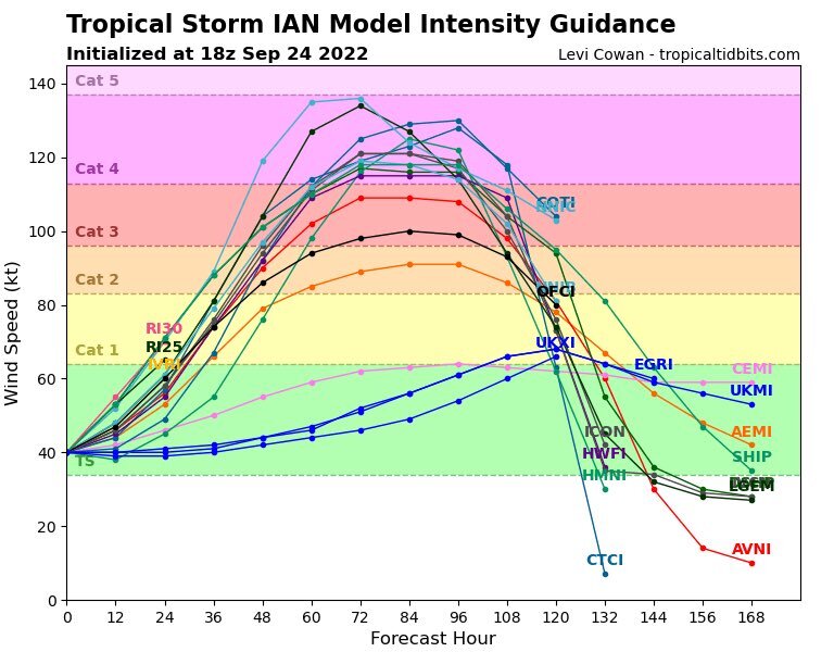
intensity models for Ian now have many members reaching CAT 3 and even CAT 4 winds. Wherever this ends up the storm surge could be devastating
-
Yea. Thankfully we have a slew of recon flights scheduled to probe things over the next few days. One is in the storm as I type this.
-
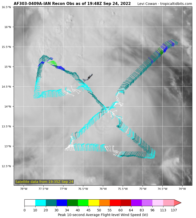
Recon is finding lows at both 13N and 14.5N. Convection is north of that. At some point in the next 24 hours one of those should dominate. If the southern one wins out then we are looking at potentially a weaker storm on a more westerly track into the Golf. If the more northern low wins it means the storm can get more robust and have an easterly bend bringing it well into the Florida west coast. these two scenarios kind of reflect the GFS vs Euro solutions playing out
-
For what it’s worth JMA the Japanese Hurricane model also agrees with euro for now and a TB LF
-
Folks. Keep in mind that Euro handles convection differently from GFS Once these models are fed a stable dominant center then we can start to take them more seriously GFS and Euro
-
000 WTNT44 KNHC 241454 TCDAT4 Tropical Storm Ian Discussion Number 6 NWS National Hurricane Center Miami FL AL092022 1100 AM EDT Sat Sep 24 2022 Ian still has an asymmetric appearance in satellite imagery this morning, with most of the deep convection located over the western portion of the circulation. Tail Doppler radar and dropsonde data from a NOAA Hurricane Hunter aircraft indicate the cyclone is still vertically tilted, with the low- to mid-level center displaced to the south of the surface center. This structure is likely a product of the northerly shear that has affected the cyclone since genesis. The aircraft reported 700-mb flight-level winds of 43 kt and SFMR retrievals slightly above 35 kt, which supports keeping the initial intensity at 40 kt for this advisory. The initial motion is a bit south of due west at 260/13 kt. A generally westward motion is expected through tonight as the cyclone is steered by a narrow ridge to its north. Ian is forecast to turn northwestward on Sunday and north-northwestward on Monday as it moves across the northwestern Caribbean Sea around the periphery of the ridge. The NHC track forecast during this period has been adjusted slightly south and west of the previous one, in line with the track consensus aids. Beyond 72 h, there is still a large amount of cross-track spread in the guidance as Ian emerges into the eastern Gulf of Mexico and approaches Florida. Hopefully, data collected from special radiosonde releases beginning later today and a scheduled NOAA G-IV flight will help resolve the steering flow around Ian and deep-layer trough that is forecast to be over the eastern U.S. early next week. The guidance envelope has once again shifted westward this cycle, and the official NHC track forecast has been adjusted in this direction as well, though it still lies slightly to the east of the TVCA and HCCA aids. Further adjustments to the track forecast may be needed given the increased uncertainty in the day 3-5 period. Ian is moving into a lower shear environment over very warm waters, and it should not take long for the system to shed its tilted structure and develop an inner core. Once that occurs, significant to rapid intensification is expected while Ian crosses the northwestern Caribbean Sea. The intensity guidance unanimously supports strengthening during the next several days, and the SHIPS-RII probabilities indicate a 67 percent chance of a 65-kt intensity increase in 72 h. Therefore, the NHC track forecast has been raised from the previous one, showing Ian becoming a hurricane by late Sunday and approaching western Cuba at or near major hurricane strength by Monday night. Limited land interaction is expected as the cyclone quickly passes over western Cuba, and Ian is forecast to be a major hurricane over the eastern Gulf of Mexico on Tuesday and Wednesday as it approaches the west coast of Florida. Key Messages: 1. Ian is expected to produce heavy rainfall, flash flooding, and possible mudslides in areas of higher terrain, particularly over Jamaica and Cuba. Limited flash and urban flooding is possible with rainfall across the Florida Keys and Florida peninsula through mid next week. 2. Hurricane conditions are possible in the Cayman Islands by early Monday, with tropical storm conditions possible by late Sunday. Tropical storm conditions are possible in Jamaica on Sunday. 3. Ian is forecast to move near or over western Cuba and approach the west coast of the Florida peninsula at or near major hurricane strength early next week, where there is increasing confidence in multiple life-threatening hazards: storm surge, hurricane-force winds and rainfall flooding. While it is too soon to determine the exact magnitude and location of these hazards, residents in Cuba, the Florida Keys, and the Florida peninsula should ensure they have their hurricane plan in place, follow any advice given by local officials, and closely monitor updates to the forecast. FORECAST POSITIONS AND MAX WINDS INIT 24/1500Z 14.4N 75.2W 40 KT 45 MPH 12H 25/0000Z 14.5N 76.8W 45 KT 50 MPH 24H 25/1200Z 15.5N 78.9W 55 KT 65 MPH 36H 26/0000Z 17.0N 80.7W 70 KT 80 MPH 48H 26/1200Z 18.8N 82.3W 85 KT 100 MPH 60H 27/0000Z 20.7N 83.4W 95 KT 110 MPH 72H 27/1200Z 22.7N 84.1W 100 KT 115 MPH 96H 28/1200Z 26.0N 83.9W 105 KT 120 MPH 120H 29/1200Z 28.6N 82.9W 95 KT 110 MPH $$ Forecaster Reinhart
-
-
000 WTNT34 KNHC 241752 TCPAT4 BULLETIN Tropical Storm Ian Intermediate Advisory Number 6A NWS National Hurricane Center Miami FL AL092022 200 PM EDT Sat Sep 24 2022 ...IAN EXPECTED TO RAPIDLY STRENGTHEN LATER THIS WEEKEND... SUMMARY OF 200 PM EDT...1800 UTC...INFORMATION ---------------------------------------------- LOCATION...14.2N 75.8W ABOUT 270 MI...435 KM SSE OF KINGSTON JAMAICA ABOUT 505 MI...810 KM SE OF GRAND CAYMAN MAXIMUM SUSTAINED WINDS...45 MPH...75 KM/H PRESENT MOVEMENT...W OR 260 DEGREES AT 16 MPH...26 KM/H MINIMUM CENTRAL PRESSURE...1003 MB...29.62 INCHES WATCHES AND WARNINGS -------------------- CHANGES WITH THIS ADVISORY: The government of the Cayman Islands has upgraded the Hurricane Watch to a Hurricane Warning for Grand Cayman, and has changed the Hurricane Watch to a Tropical Storm Watch for Little Cayman and Cayman Brac. SUMMARY OF WATCHES AND WARNINGS IN EFFECT: A Hurricane Warning is in effect for... * Grand Cayman A Tropical Storm Watch is in effect for... * Jamaica * Little Cayman and Cayman Brac A Hurricane Warning means that hurricane conditions are expected somewhere within the warning area. A warning is typically issued 36 hours before the anticipated first occurrence of tropical-storm-force winds, conditions that make outside preparations difficult or dangerous. Preparations to protect life and property should be rushed to completion. A Tropical Storm Watch means that tropical storm conditions are possible within the watch area, generally within 48 hours. Interests in western and central Cuba, the Florida Keys, and the Florida peninsula should monitor the progress of Ian. For storm information specific to your area, please monitor products issued by your national meteorological service. DISCUSSION AND OUTLOOK ---------------------- At 200 PM EDT (1800 UTC), the center of Tropical Storm Ian was located near latitude 14.2 North, longitude 75.8 West. Ian is moving toward the west near 16 mph (26 km/h), and this general motion is expected to continue through tonight. A turn toward the northwest is forecast on Sunday, followed by a north-northwestward turn on Monday and a northward motion on Tuesday. On the forecast track, the center of Ian is forecast to pass southwest of Jamaica on Sunday, and pass near the Cayman Islands Sunday night and early Monday. Ian will then approach western Cuba late Monday and emerge over the southeastern Gulf of Mexico on Tuesday. Maximum sustained winds remain near 45 mph (75 km/h) with higher gusts. Significant strengthening is forecast during the next few days. Ian is expected to become a hurricane late Sunday or Sunday night and could be at or near major hurricane strength late Monday when it approaches western Cuba. Tropical-storm-force winds extend outward up to 60 miles (95 km) from the center. The estimated minimum central pressure is 1003 mb (29.62 inches). HAZARDS AFFECTING LAND ---------------------- Key messages for Ian can be found in the Tropical Cyclone Discussion under AWIPS header MIATCDAT4 and WMO header WTNT44 KNHC and on the web at hurricanes.gov/text/MIATCDAT4.shtml. WIND: Hurricane conditions are expected to reach Grand Cayman by early Monday, with tropical storm conditions expected by Sunday night. Tropical storm conditions are possible on Jamaica by Sunday, and on Little Cayman and Cayman Brac by Sunday night. RAINFALL: Ian is expected to produce the following rainfall: Southern Haiti and southern Dominican Republic: 2 to 4 inches, with local maxima up to 6 inches Jamaica and the Cayman Islands: 4 to 8 inches, with local maxima up to 12 inches Western to central Cuba: 6 to 10 inches, with local maxima up to 14 inches Florida Keys and south Florida: 1 to 3 inches, with local maxima up to 5 inches through Tuesday morning These rains may produce flash flooding and mudslides in areas of higher terrain, particularly over Jamaica and Cuba. Flash and urban flooding is possible with rainfall across the Florida Keys and the Florida peninsula through mid next week. Additional flooding and rises on area streams and rivers across Florida cannot be ruled out through next week given already saturated antecedent conditions. STORM SURGE: Storm surge could raise water levels by as much as 2 to 4 feet above normal tide levels along the immediate coast in areas of onshore winds in the Cayman Islands Sunday night into Monday. Localized coastal flooding is possible along the coast of Jamaica in areas of onshore winds on Sunday. SURF: Swells generated by Ian will begin affecting Jamaica and the Cayman Islands on Sunday and spread westward to Cuba by Monday. These swells are likely to cause life-threatening surf and rip current conditions. Please consult products from your local weather office. NEXT ADVISORY ------------- Next complete advisory at 500 PM EDT. $$ Forecaster Reinhart