Hotair
-
Posts
548 -
Joined
-
Last visited
Content Type
Profiles
Blogs
Forums
American Weather
Media Demo
Store
Gallery
Everything posted by Hotair
-
18z
-
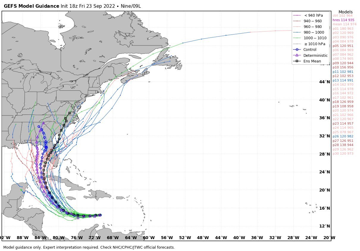
000 WTNT34 KNHC 232345 TCPAT4 BULLETIN Tropical Depression Nine Intermediate Advisory Number 3A NWS National Hurricane Center Miami FL AL092022 800 PM EDT Fri Sep 23 2022 ...DEPRESSION EXPECTED TO BECOME A TROPICAL STORM TONIGHT OR ON SATURDAY... SUMMARY OF 800 PM EDT...0000 UTC...INFORMATION ---------------------------------------------- LOCATION...14.8N 71.5W ABOUT 410 MI...660 KM ESE OF KINGSTON JAMAICA ABOUT 720 MI...1160 KM ESE OF GRAND CAYMAN MAXIMUM SUSTAINED WINDS...35 MPH...55 KM/H PRESENT MOVEMENT...WNW OR 290 DEGREES AT 15 MPH...24 KM/H MINIMUM CENTRAL PRESSURE...1006 MB...29.71 INCHES WATCHES AND WARNINGS -------------------- CHANGES WITH THIS ADVISORY: None. SUMMARY OF WATCHES AND WARNINGS IN EFFECT: A Hurricane Watch is in effect for... * Cayman Islands A Tropical Storm Watch is in effect for... * Jamaica A Hurricane Watch means that hurricane conditions are possible within the watch area. A watch is typically issued 48 hours before the anticipated first occurrence of tropical-storm-force winds, conditions that make outside preparations difficult or dangerous. A Tropical Storm Watch means that tropical storm conditions are possible within the watch area, generally within 48 hours. For storm information specific to your area, please monitor products issued by your national meteorological service. DISCUSSION AND OUTLOOK ---------------------- At 800 PM EDT (0000 UTC), the center of Tropical Depression Nine was located near latitude 14.8 North, longitude 71.5 West. The depression is moving toward the west-northwest near 15 mph (24 km/h). A westward motion is expected to begin tonight and continue through Saturday night, followed by a turn toward the northwest and north-northwest on Sunday and Monday. On the forecast track, the center of the cyclone is forecast to move across the central Caribbean Sea through Saturday, pass south of Jamaica on Saturday night and Sunday, and approach the Cayman Islands on Sunday night and early Monday. Maximum sustained winds are near 35 mph (55 km/h) with higher gusts. Some slow strengthening is forecast during the next day or so, and the depression is expected to become a tropical storm tonight or on Saturday. More significant intensification is forecast on Sunday and Monday, and the system is forecast to become a hurricane by early Monday. The estimated minimum central pressure is 1006 mb (29.71 inches). HAZARDS AFFECTING LAND ---------------------- Key messages for Tropical Depression Nine can be found in the Tropical Cyclone Discussion under AWIPS header MIATCDAT4 and WMO header WTNT44 KNHC and on the web at hurricanes.gov/text/MIATCDAT4.shtml. WIND: Hurricane conditions are possible in the Cayman Islands by early Monday, with tropical storm conditions possible by late Sunday. Tropical storm conditions are possible on Jamaica by Sunday. RAINFALL: Tropical Depression Nine is expected to produce the following rainfall: Southern Haiti and Southern Dominican Republic: 2 to 4 inches, with local maximum up to 6 inches Jamaica and the Cayman Islands: 4 to 8 inches, with local maximum up to 12 inches Western to central Cuba: 6 to 10 inches, with local maximum up to 14 inches. Heavy rains may begin to affect South Florida on Monday. Limited flash and urban flood impacts may be possible with this rainfall. These rains may produce flash flooding and mudslides in areas of higher terrain, particularly over Jamaica and Cuba. STORM SURGE: Storm surge could raise water levels by as much as 1 to 3 feet above normal tide levels along the immediate coast in areas of onshore winds in the Cayman Islands Sunday night into Monday. Localized coastal flooding is possible along the coast of Jamaica in areas of onshore winds on Sunday. SURF: Swells generated by this system will begin affecting Jamaica, the Cayman Islands, and Cuba over the next several days. These swells are likely to cause life-threatening surf and rip current conditions. Please consult products from your local weather office. NEXT ADVISORY ------------- Next complete advisory at 1100 PM EDT. $$ Forecaster Berg
-
I hear you. I threw away my Irma (I’m pretty sure it was Irma) plywood to make room for another car in the garage. Same concerns. The storage racket here is insane as no homes have basements and few have useable attics @NWSTampaBay now says 83mph winds w/ gusts of 103mph Wends afternoon in Sarasota. Yikes!
-
I’m right at the center of the cone here in Tampa. The one positive is that 5 days out, the likelihood of that trajectory staying unchanged is next to nil. Still concerning as I am in no position right now to board up anything as I was released from hospital just last week. Also the cost of plywood makes covering windows a rich man’s game. $780 is the quote I just got using OsB. anyhow to make this relevant. We will be getting an intermediate advisory on #TD9 at 8 PM
-
Models are converging in a way that suggest significant Hurricane effects across Havana Cuba. This would be devastating for the people there as food is already scarce across the country and Havana is of course densely populated.
-
Thanks. Yes I see that now. Sites like this one are incorrectly labeling it as Newton https://patch.com/florida/southtampa/tropical-storm-newton-could-become-seasons-most-significant-storm?utm_source=alert-breakingnews&utm_medium=email&utm_campaign=alert
-
I thought this was interesting Mike Ventrice @MJVentrice Accumulated Cyclone Energy (ACE) for the Atlantic Hurricane Season is running at 13% of normal.
-
13/6/2
-
Let’s hope the hospital has ample fuel and working generators. Many folks there rely on oxygen generators working to live.
-
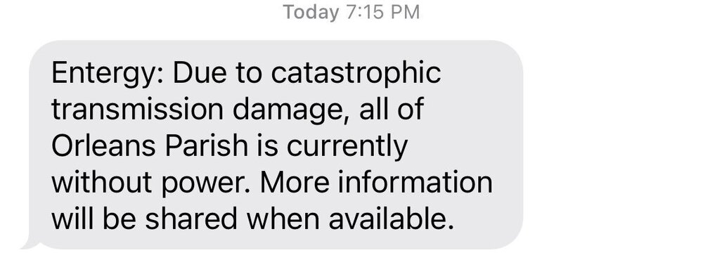
All of NO without power due to “catastrophic transmission damage”
-
They have retracted the report https://www.facebook.com/2185792338184744/posts/4202099536554004/
-
Live cam in grand isle getting interesting https://www.severestudios.com/storm-chasers/john.humphress2.html#.YSuPdlhCzcQ.twitter
-
But she went ahead and issues the order today. One day later. Help me understand how enough time became available one day later?
-
I didn’t say these were the Katrina trailers. Katrina started the whole FEMA trailer business. They just continue to buy trailers and then dispose of them when they are not needed. I was suggesting that they should have kept those trailers instead of selling them as surplus cause I’m sure they will be needed again after next week
-
10a advisory just issued https://t.co/SzI4KXHTBt?amp=1
-
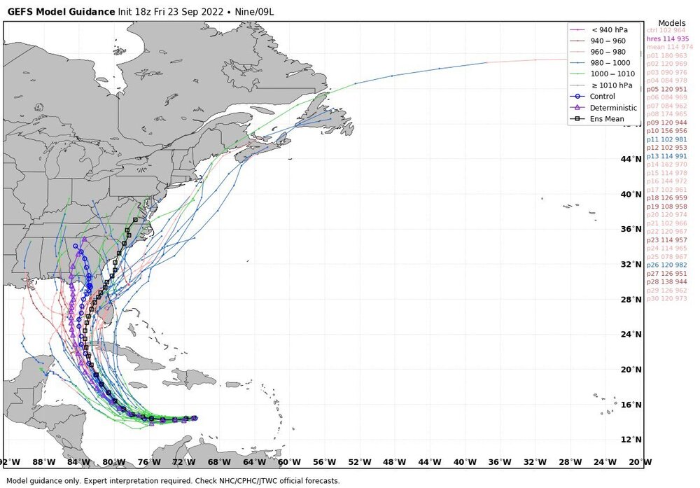
WRF and HMON have both returned nearly identical onshore trajectories that put landfall west of NO. Does anyone know if the longitude they were initialized under is still valid or has Ida wobbled further East since those runs ?
-
I know I know. Just amazed how they justify spending 65k on a trailer when you can put a family in a hotel room for 3k a month or less.
-
Remember how FEMA provided trailers after Katrina? In 2019 FEMA sold another batch of trailers that were never used. They cost taxpayers an average of $ 65k each and were auctioned off starting at just $100 https://www.wjhg.com/content/news/FEMA-trailers-stored-at-Texas-airport-being-auctioned-off-for-a-fraction-of-what-they-cost-505664771.html
-
Crazy long lines at the airport right now https://twitter.com/Jasamsdestiny/status/1431760176172847104?s=20
-
Remember Ray Nagin ? Apparently he is now on house arrest in New Orleans. Bet he is not looking forward to reliving that ordeal
-
Come Monday many folks in LA will be saying “if I’d known Ida was gonna be this bad Ida gotten outta here” ill let myself out
-
man. That ida keeps leaning East with each minute. More and more critical infrastructure in harms way with each step to the right
-
Nice Live high def cam stream of bourbon St New Orleans. Hopefully remains up into tomorrow Earthcam bourbon st live stream
-
I am surprised by how tight the trajectory cluster of all models is now still some 24-30 hours away from landfall. Usually we get somewhat greater spread and more outliers, but I don’t see that here. SE Louisiana is in for a beating.
-
I wonder if the people that refuse to wear masks or get vaccinated are the same people who also feel that plywood and sandbags are not effective deterrents against the wind and water from the storm?