Hotair
-
Posts
548 -
Joined
-
Last visited
Content Type
Profiles
Blogs
Forums
American Weather
Media Demo
Store
Gallery
Everything posted by Hotair
-
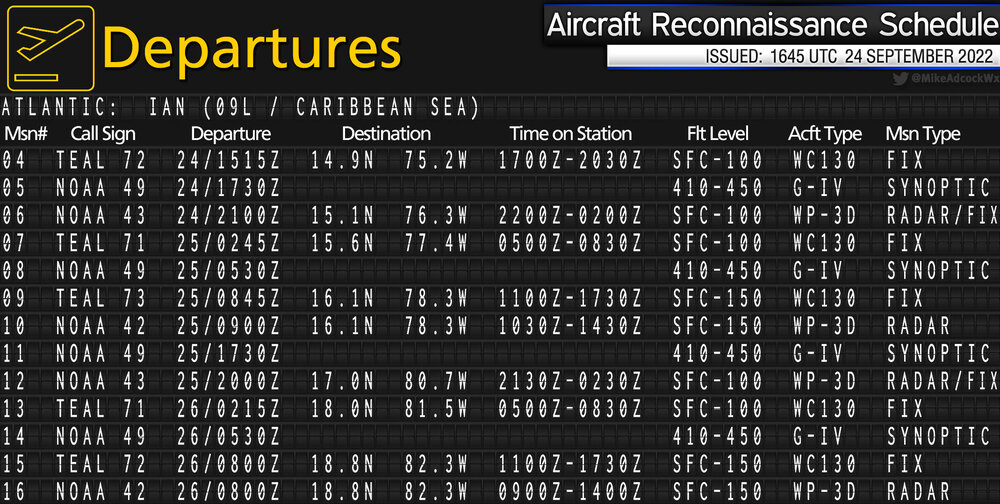
Near term Ian recon flight schedule for those who may be interested
-
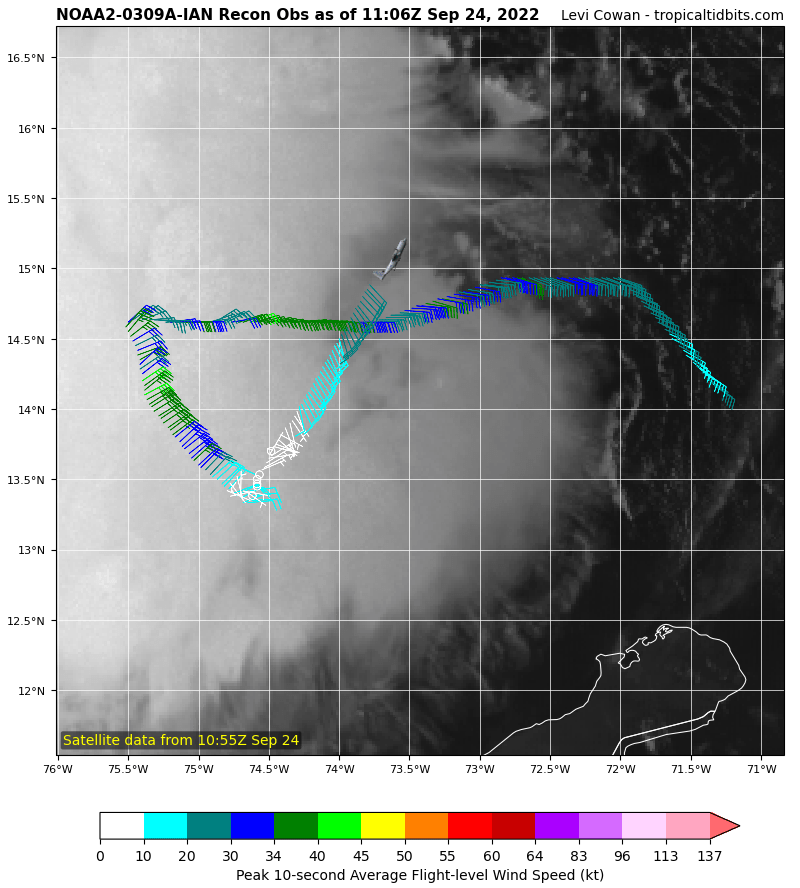
Center fix for Ian now is a full degree further north than the center fix from this morning's recon. Neither of these fixes were assimilated into 12z guidance, so any model trends prior to 00z tonight probably should be taken with a grain of sand
-
I’m not ready to place lots of faith in any of the models just yet. The last Recon data we got showed Ian was still a broad, messy system that wasn't vertically stacked and had multiple competing centers. we should be getting new recon data in the next hour or so that may reveal if a dominant center has established. At that point, models can be fed with more reliable initial conditions. Thoughts?
-
Battle of the models. I’m of course rooting for GFS westerly /weaker track but ECMWF still had Ian crushing SW Florida
-
Philippe Papin @NWSNHC The TDR data from @NOAA_HurrHunter P3 is very useful for diagnosing TC #Ian's structure. Center tilt b/w 1-km to 6-km is SW, but tilts back N at 10km. Neat to see how tilt evolves w/ height Even though shear has lowered, structure not ready for significant deepening yet.
-
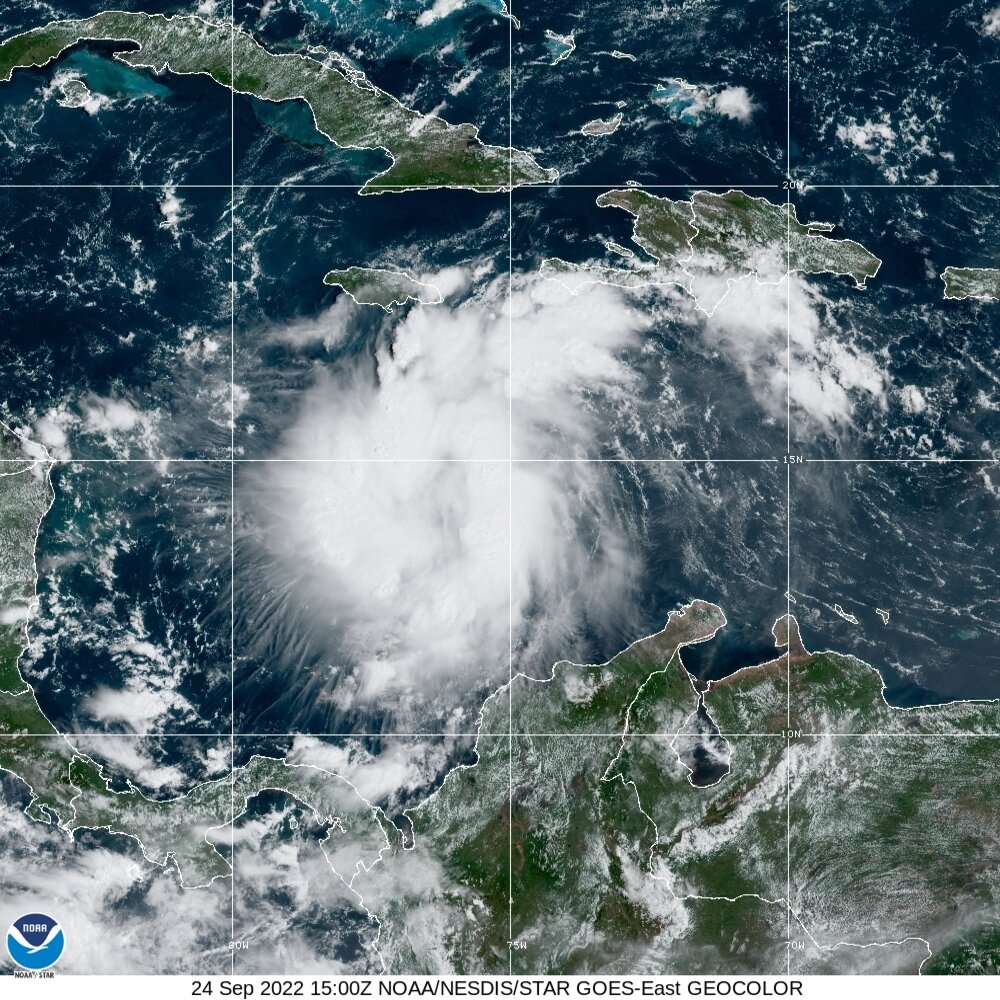
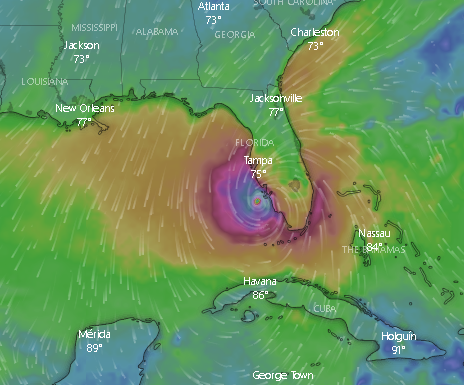
It is getting prettier. As of 11:29

-
Ian track takes it over seas with ocean heat content of 140-200 kJ/cm2 in the Caribbean Sea, Yucatán Channel & eastern Gulf of Mexico. Values in excess of 100 kJ/cm2 lend support to rapid intensification of hurricanes. in the absence of excessive shear or dry air, RI is almost assured.
-
Visual sat imagery shows Ian is expanding its outflows along all quadrants.
-
-
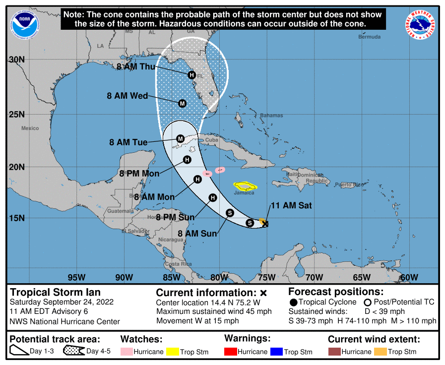
000 WTNT34 KNHC 241453 TCPAT4 BULLETIN Tropical Storm Ian Advisory Number 6 NWS National Hurricane Center Miami FL AL092022 1100 AM EDT Sat Sep 24 2022 ...IAN FORECAST TO RAPIDLY STRENGTHEN LATER THIS WEEKEND... ...HURRICANE CONDITIONS POSSIBLE IN THE CAYMAN ISLANDS EARLY MONDAY... SUMMARY OF 1100 AM EDT...1500 UTC...INFORMATION ----------------------------------------------- LOCATION...14.4N 75.2W ABOUT 270 MI...435 KM SSE OF KINGSTON JAMAICA ABOUT 520 MI...840 KM SE OF GRAND CAYMAN MAXIMUM SUSTAINED WINDS...45 MPH...75 KM/H PRESENT MOVEMENT...W OR 260 DEGREES AT 15 MPH...24 KM/H MINIMUM CENTRAL PRESSURE...1003 MB...29.62 INCHES WATCHES AND WARNINGS -------------------- CHANGES WITH THIS ADVISORY: None. SUMMARY OF WATCHES AND WARNINGS IN EFFECT: A Hurricane Watch is in effect for... * Cayman Islands A Tropical Storm Watch is in effect for... * Jamaica A Hurricane Watch means that hurricane conditions are possible within the watch area. A watch is typically issued 48 hours before the anticipated first occurrence of tropical-storm-force winds, conditions that make outside preparations difficult or dangerous. A Tropical Storm Watch means that tropical storm conditions are possible within the watch area, generally within 48 hours. Interests in western and central Cuba, the Florida Keys, and the Florida peninsula should monitor the progress of Ian. For storm information specific to your area, please monitor products issued by your national meteorological service. DISCUSSION AND OUTLOOK ---------------------- At 1100 AM EDT (1500 UTC), the center of Tropical Storm Ian was located near latitude 14.4 North, longitude 75.2 West. Ian is moving toward the west near 15 mph (24 km/h), and this general motion is expected to continue through tonight. A turn toward the northwest is forecast on Sunday, followed by a north-northwestward turn on Monday and a northward motion on Tuesday. On the forecast track, the center of Ian is forecast to move across the central Caribbean Sea today, pass southwest of Jamaica on Sunday, and pass near or over the Cayman Islands Sunday night and early Monday. Ian will then approach western Cuba late Monday and emerge over the southeastern Gulf of Mexico on Tuesday. Maximum sustained winds remain near 45 mph (75 km/h) with higher gusts. Significant strengthening is forecast during the next few days. Ian is expected to become a hurricane late Sunday or Sunday night and could be at or near major hurricane strength late Monday when it approaches western Cuba. Tropical-storm-force winds extend outward up to 60 miles (95 km) from the center. The estimated minimum central pressure is 1003 mb (29.62 inches) based on NOAA Hurricane Hunter dropsonde data. HAZARDS AFFECTING LAND ---------------------- Key messages for Ian can be found in the Tropical Cyclone Discussion under AWIPS header MIATCDAT4 and WMO header WTNT44 KNHC and on the web at hurricanes.gov/text/MIATCDAT4.shtml. WIND: Hurricane conditions are possible in the Cayman Islands by early Monday, with tropical storm conditions possible by Sunday night. Tropical storm conditions are possible on Jamaica on Sunday. RAINFALL: Ian is expected to produce the following rainfall: Southern Haiti and southern Dominican Republic: 2 to 4 inches, with local maxima up to 6 inches Jamaica and the Cayman Islands: 4 to 8 inches, with local maxima up to 12 inches Western to central Cuba: 6 to 10 inches, with local maxima up to 14 inches Florida Keys and south Florida: 1 to 3 inches, with local maxima up to 5 inches through Tuesday morning These rains may produce flash flooding and mudslides in areas of higher terrain, particularly over Jamaica and Cuba. Flash and urban flooding is possible with rainfall across the Florida Keys and the Florida peninsula through mid next week. Additional flooding and rises on area streams and rivers across Florida cannot be ruled out through next week given already saturated antecedent conditions. STORM SURGE: Storm surge could raise water levels by as much as 2 to 4 feet above normal tide levels along the immediate coast in areas of onshore winds in the Cayman Islands Sunday night into Monday. Localized coastal flooding is possible along the coast of Jamaica in areas of onshore winds on Sunday. SURF: Swells generated by Ian will begin affecting Jamaica and the Cayman Islands on Sunday and spread westward to Cuba by Monday. These swells are likely to cause life-threatening surf and rip current conditions. Please consult products from your local weather office. NEXT ADVISORY ------------- Next intermediate advisory at 200 PM EDT. Next complete advisory at 500 PM EDT. $$ Forecaster Reinhart
-
Statistical probabilities for RI are all rather favorable. See here https://tropic.ssec.wisc.edu/real-time/ai-ri/
-
Fun fact: “I” is the most frequent storm name letter to be retired also, missing from most Hurricane readiness lists, but just as critical: cigarettes, cold beer, diesel fuel and cash When you have storm damage and need to lure someone with a chainsaw or a tarp to your property first, these are the essential bargaining chips.
-
@MJVentrice Put it up on his channel Edit: tool developed by @alanbrammer based on watermark
-
I like best how this graphic shows the slight Westward shift in guidance. Clearly sucks for Tampa Bay but we can hope the trend continues Dark line is the latest model track
-
Cuba is not expecting it until Tuesday so we still have 4-5 days of tracking in front of us. Even a TS headed directly into Tampa Bay would cause considerable flooding damage to the area. Timing of LF and tide will be crucial here. I guess my concern here in Tampa is not so much the winds (building codes here are good through CAT 2 ) but the flooding potential especially if it stalls in the vicinity. edit: just to vent, ridiculous that Hillsborough county in Tampa has no plans to provide sandbags to residents. Prior storms where we were well outside the cone, sand was made available. Pretty disappointing.
-
Lots of variables here including how much interaction we see with Cuba’s Western end. The more West it moves now the less opportunity for Cuba to disrupt it some. Helps the SW coast of Florida, but perhaps means a stronger storm headed to the panhandle
-
Which for now, makes it more dangerous for Tampa Bay unfortunately
-
Recon data showing the start of circulation

-
Just fyi for those who are visiting or plan on flying out of the area ahead of Ian Tampa, Clearwater and Sarasota airports may discontinue service as early as Monday afternoon. Plan accordingly.
-
I’m sorry, not understanding. Only chance for what? Lf as a hurricane? Even if winds are not catastrophic, the potential for flooding damage seems significant if it makes it anywhere near Tampa, No?
-
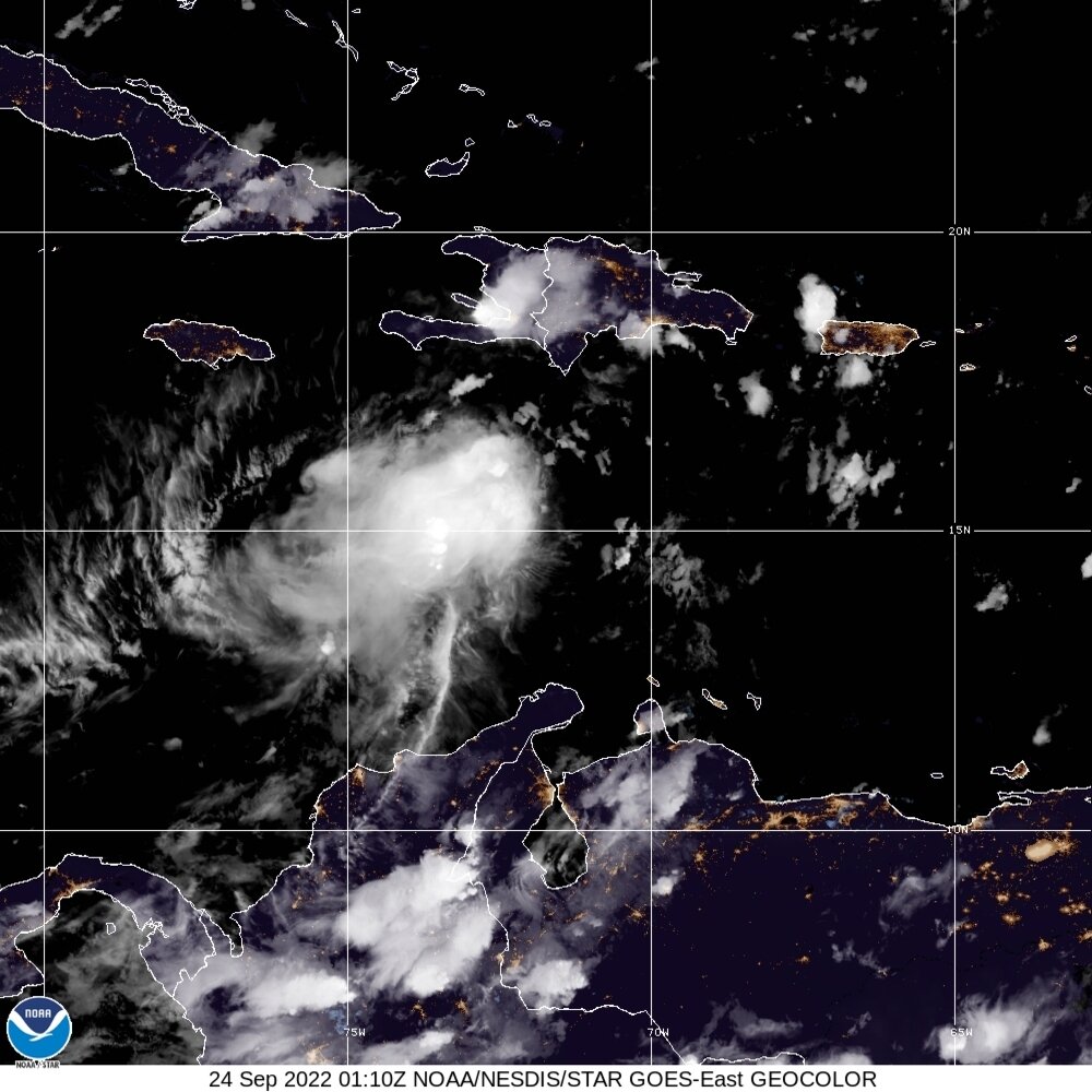
Im turning in. Time for some meds that make me drowsy. Here is the latest sat presentation as of approx 9:30

-
SEVEN recon flights are scheduled between tomorrow and Sunday morning with more scheduled for Sunday afternoon and evening. 2 high altitude missions, 2 tail radar missions and 3 additional fix flights. The NHC probably has surplus budget this year that has gone unused so they are going to be providing great coverage of this storm.
-
Roger that. Ian confirmed. Someone opening a new thread?
-
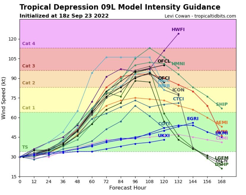
Anyone post the latest intensity model guidance yet? Here it is
-
And don’t get me started on windstorm insurance