

RevWarReenactor
-
Posts
4,453 -
Joined
-
Last visited
About RevWarReenactor

Recent Profile Visitors


-
Feb 22nd/23rd "There's no way..." Obs Thread
RevWarReenactor replied to Maestrobjwa's topic in Mid Atlantic
Well I got great news for you I’m absolutely 100% positively done with tracking snow for the mid Atlantic. I won’t be here anymore. Most of you are bullies and trash human beings anyway. (Limited exceptions aside) something I should have known decades ago. -
Feb 22nd/23rd "There's no way..." Obs Thread
RevWarReenactor replied to Maestrobjwa's topic in Mid Atlantic
Lol- good times.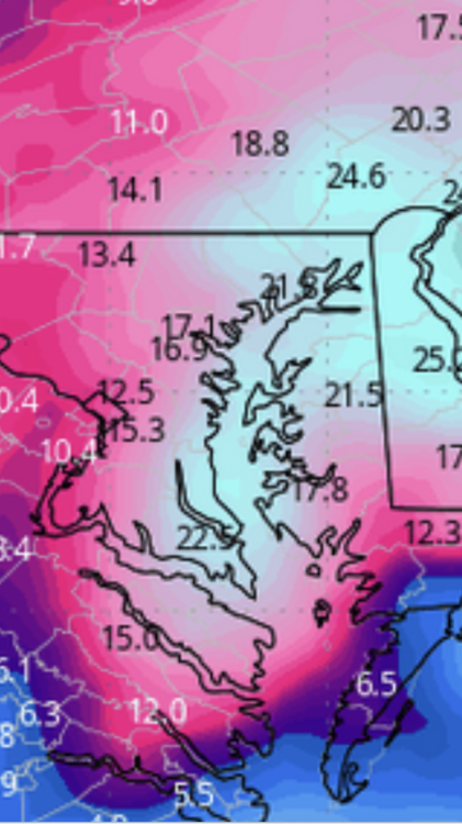
-
I mean, if you consider tracking 1-2 slushy inches while NJ gets a historic blizzard a "win". Go for it. As it turns out though, I was right. As per usual.
-
Damn 7 minutes and your dumbass still hasn't deleted my account. Might want to speed it up, im going to be sending out PMs to people telling them what I really think about them.
-
Delete my account right fucking now or I am filing a lawsuit against you.
-
Making literally one or two posts with factual statements like "Climo says this storm won't happen" is upsetting? I think you all need some real problems. Sure, we dig up ancient history and say im not blameless. There is some truth there. But if we just focus on the now and keep it on the weather. The outrage is ridiculous. Nothing I said was upsetting or meant to be upsetting. This is all hilarious. GFS leads the way on a storm, Euro is a no, not much ensemble support, climo, and making a statement like "I don't think this storm is happening" is panic? Like what planet are you living on?
-
Who are you again? I've been posting on these boards for almost 30 years. Im not going anywhere.
-
Funny you mention a therapist. Because I've discussed at length the decades of what people have said here, and their conclusion is you are bullies and I need to defend myself even if I've felt 60% of the insults were in good fun. Since disrespect slowly erodes self esteem even when its a "joke". I guess my therapist is wrong too, right! LOL
-
Help me to understand Mappy. What do you find so offensive about saying that a storm is unlikely based on climo? It’s literally the best most accurate analysis in there. I don’t get the controversy at all. I’m not disruptive either. My posts are maybe 1 post per like 50 pages. If you 5 posted ne I’d still have 4 excess posts a day. I think You all just need someone to bully. It’s sad.
-
@mappy @TSSN+ remember the arrogance I mentioned? How you all think you are better than others. This is your reminder that you aren’t better than me. Go bully another poster. There isn’t a single thing I’ve said that is bad. You just love to bully posters your think are less than. It gets old after awhile.
-
Late February/Early March 2026 Mid-Long Range
RevWarReenactor replied to WxUSAF's topic in Mid Atlantic
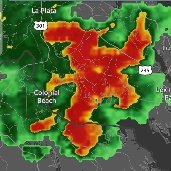
Reminds me of the Jan 2022 storm. I think Atlantic City got 18 inches and DC got nothing. Not say thing thats the final outcome but certainly plausible for sure. -
Yet 90% of the time, the people who say the models are full of crap and that we aren't getting a storm, end up being correct. And all the rest of the post are actually the garbage.
-
Late February/Early March 2026 Mid-Long Range
RevWarReenactor replied to WxUSAF's topic in Mid Atlantic
You all are living in the land of delusion. Climo absolutely says no to this one. You might say thats trolling or banter. But It will turn out to be the best analysis in here come Sunday. Just wait. -
Late February/Early March 2026 Mid-Long Range
RevWarReenactor replied to WxUSAF's topic in Mid Atlantic
So neither the Euro or GFS show a big storm. But ya know, no big deal.


