

CheeselandSkies
-
Posts
2,961 -
Joined
-
Last visited
Content Type
Profiles
Blogs
Forums
American Weather
Media Demo
Store
Gallery
Posts posted by CheeselandSkies
-
-
14 hours ago, CheeselandSkies said:

All eyes squarely back on Lee, now. Even though Jova is still kinda pretty she's getting a little long in the tooth. Quite literally yesterday's news.
-
5 hours ago, nycwinter said:
i doubt lee will ever look as good as jova does..
Some of the HAFS-B runs would disagree, but we'll see what happens.
-
-
5 hours ago, hardypalmguy said:
A little cooler interlude next week but signs are there for big heat in the last half of the month.
Based on what? Not the >300 hour GFS op again, right?
-
 2
2
-
-
The "I curse" is real, folks.
Retirements since 2002:
Isidore, Isabel, Ivan, Ike, Igor, Irene, Ingrid, Irma, Ida, Ian
Now likely Idalia.
Kind of ironic that 2005 didn't manage to retire an "I" name, but the infamous 2013 did.
-
 2
2
-
-
Just now, NERMAN said:
HMON and HAFS-A are both in the mid 950's. Splitting the difference with the two you mentioned gets a strong cat 3 to low-end cat 4.
Fair enough.
-
1
-
-
May not be much on the immediate coast but some of the hurricane model solutions would put the western eyewall over Tallahassee; with how fast this thing is going to be trucking inland I'd expect they would get a lot more wind than during Michael if those verified.
-
1
-
-
18 minutes ago, NERMAN said:
Hurricane models held landfall intensity at 12Z from strong Cat 3 to low-end Cat 4 tracking toward Big Bend
I would wager 931 MB on the HWRF and 926 MB on the HAFS-B (both FH051) are not "strong Cat 3 to low-end Cat 4" verbatim.
BTW, is there any other way to pronounce the new hurricane model besides "half-ass"? I can't think of one.

-
1
-
2
-
-
Just now, CoastalWx said:
I know that. Just showing that 12z guidance is available.

I prefer to wait for the actual frame-by-frame model runs of the hurricane models (HAFS-A/B, HWRF, HMON) with MSLP, sim IR, etc.
-
2
-
-
3 minutes ago, CoastalWx said:
Tropical Tidbits has them.
Where? All still the 06Z runs for me.
-
1 minute ago, dan11295 said:
NHC now not showing quite as much intensification prior to landfall. the 12z intensity models on Tropical Tidbits have also pulled back a bit, keeping Idalia and strong 2 to weak 3. Of course RI can be hard to predict, so can't assume anything from that.
The 12Z hurricane models aren't actually out yet, and won't be for another few hours.
-
 1
1
-
-
0Z HAFS-B gets it down to 929 MB (strongest non-fantasy range hurricane model output I've seen thus far) at FH057, but brings it back up a bit before landfall. All the hurricane models (and have for several runs) agree on a solid major hurricane, potentially a high-end (125kt+) one.
-
1 hour ago, cptcatz said:
There are now 5 or 6 EPS members looping and ending with Franklin moving southwest back towards the US...
I don't even want to imagine the shenanigans that would be possible with Franklin and Idalia both drifting around in the western Atlantic late in the coming week.
-
2
-
-
Quote
...IDALIA STRENGTHENING QUICKLY... ...HURRICANE WARNING ISSUED FOR THE CUBAN PROVINCE OF PINAR DEL RIO...
-
2
-
-
18Z GFS with the casual 2MB/hr pressure drops continuing for 24 hours straight.

-
 1
1
-
-
12Z GFS down to 960 MB, deepening on approach.
IMO surge risk to Big Bend is higher with this storm than any for a long time. The coast is sparsely populated, but if this does come in as a strong major and causes a swath of intense wind damage deep inland, as others pointed out it's all mobile homes and RV parks in there.
-
HAFS-A is at 956 MB just offshore, at FH078. Next frame, at FH081, is at 954 MB well inland.
-
Special Message from NHC Issued 26 Aug 2023 20:16 UTC NHC will initiate advisories on Tropical Depression Ten, located near the Yucatan Peninsula of Mexico, at 400 PM CDT (2100 UTC).-
9
-
-
If the latest HWRF verifies (again, not saying this is the most likely solution); western Cuba is in for a solid hurricane in less than 48 hours. Then after that...
Looks like last night's 0Z run was a glitch in the matrix for the famously bullish hurricane model. Both 12Z HAFS also go nuts.
-
11 minutes ago, Normandy said:
Morning trends make it very obvious that this is consolidating further east, and I’m not sure what is going to drive this west into the yucatan as models are suggesting. Still like the idea of a major hurricane into the FL peninsula somewhere near Tampa.
I wouldn't call it likely at this point but would be foolish to take anything off the table at this juncture.
-
00Z HWRF is gonna be fun...985 MB already at FH054.
Edit: Maybe not. Seems to be struggling with shear or something and still hovering in the 980s by midday Tuesday. I'm off to bed.
-
2 minutes ago, WxWatcher007 said:
Keep in mind that the HWRF is in the process of retirement so I’d look at HAFS-A/B now.
Both are much further west (central to western Panhandle) and not as strong, but B would be a solid Cat. 1 and A a mid Cat. 2 at least with 967 MB just after landfall at FH111. Like HWRF that's also a large pressure drop in the 3 hours before landfall.
-
IIRC Ida of 2021 was the one that was pretty well pegged as a dangerous Gulf major even as an invest. With Ian there was some initial thought that it would get left behind and limp into the Big Bend as an unraveling TS/minimal Cat. 1 at most.
The intensity of Michael was very much a sneak attack. The lesson here again is "never count out a northward-moving Gulf storm with boiling waters in its path because it's too early to tell whether it will be destructively sheared or not."
-
6
-
-
2 hours ago, TheGhostOfJohnBolaris said:
18z HWRF is a pretty dramatic change in intensity
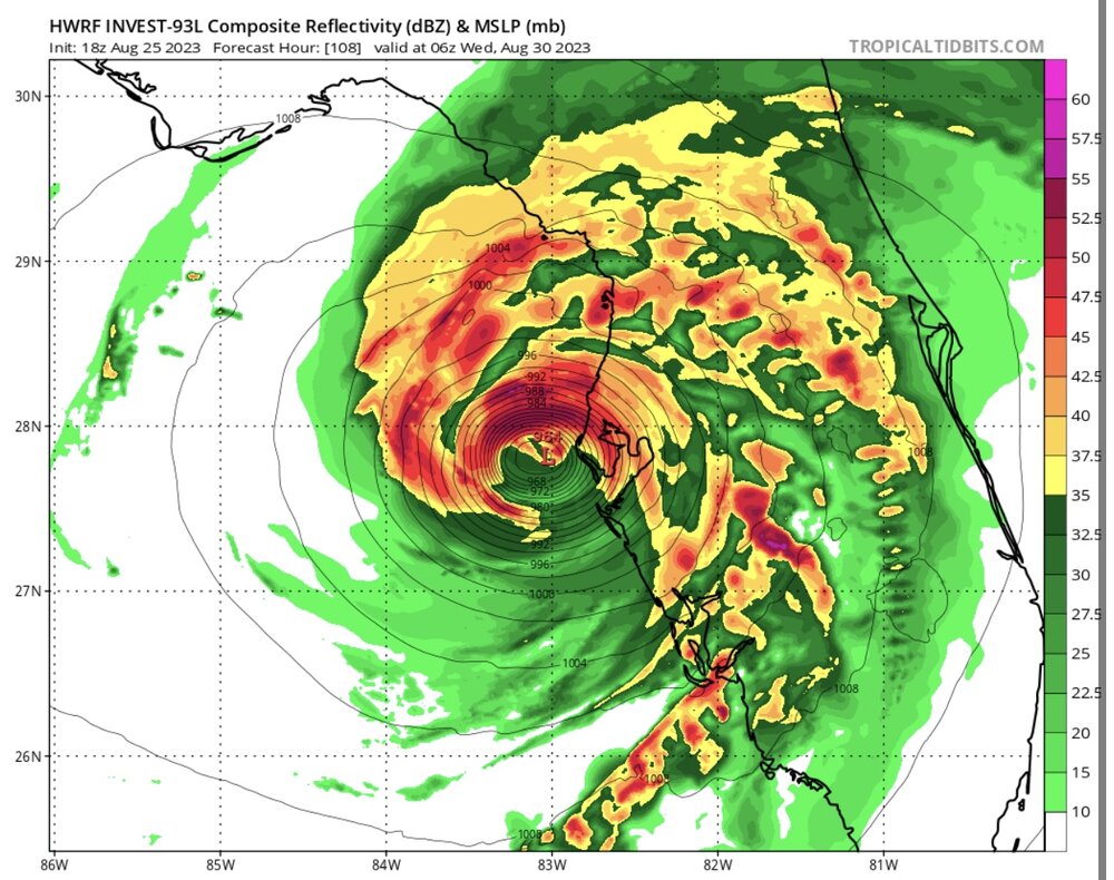
Even has it down to 959MB right on the coast at FH111...too bad there's not a sim IR frame for that FH.


Lee banter thread
in Tropical Headquarters
Posted