-
Posts
2,988 -
Joined
-
Last visited
Content Type
Profiles
Blogs
Forums
American Weather
Media Demo
Store
Gallery
Posts posted by CheeselandSkies
-
-
I wonder if the HRRR is still having those overmixing issues @andyhb mentioned and if so, at what point it will catch on.
-
Interesting the HRRR still blows up that monster simulated supercell in IL tomorrow but the environment ahead of it is not really impressive...super mixed and with ho-hum low-level shear. I can't get a good sounding in proximity to it that both has impressive parameters and isn't contaminated.

Also interesting that the globals (namely EURO) are more bullish on convection than the CAMs.
-
 1
1
-
-
@andyhb What do you make of some of these RAP soundings? Parameters are absolutely off the chains but there's that pesky low-level inversion. Just the other day we were talking about temps in the 80s and mixing issues, but a lot of these seem too cool (uppers 60s/low 70s) almost like we're more used to seeing from the NAM?
-
11 minutes ago, cyclone77 said:
Gotta work till 4 but will be out after that. I'm riding the consistent Euro and FV3 till I go down in flames lol. Parameters too strong for me to sit this one out.
Yeah, I agree on that.
-
2 hours ago, Malacka11 said:
I thought roughly the same area is in play tomorrow?
That was initial thinking but now looking like the trough is ejecting more slowly.
-
With the Day 3 update I'm wondering now if Tuesday's initiation (if any) will be too far west for me to chase, even though it should be quite a bit later than last Friday's.
Not really keen on a west of I-35 target after working 3AM-noon. Was one of the things that made Friday a no-brainer go for me.
-
7 minutes ago, Chicago Storm said:
They do. Risk level is coverage based and hatching is for significance.
Their system is still quite flawed, though.
I think the main things that's' not always conveyed is that oftentimes the sparser the storm coverage, the more dangerous the hazards can be from any one storm. Meteorologists & chasers know it, but EMs and the general public usually do not.
-
22 minutes ago, Witness Protection Program said:
Yeah, I only found out about that when I was looking through the Wikipedia tornado list last night (still waiting on DVN to officially confirm the handoff near Keota instead of having one EF4 path all the way from Wapello County up to Johnson County, been spamming them on Facebook with me and @hlcater's video). Sounds horrible, but they actually got lucky it wasn't a stronger tornado.
-
17 minutes ago, Chicago916 said:
Very late day 2 convective outlook.
Out now...very interesting and rather ominous wording for both ends of the setup (southern one also upgraded to tornado-driven MDT).
-
 2
2
-
-
12 minutes ago, brianc33710 said:
Check out some of these STPs. I thought the max was 20!
https://twitter.com/realStarInBox/status/1642715078809067521/photo/1
OK so this may or may not work.....
EDIT The link opens. I just couldn't share the photo itself.
The max I do see is 20...right on the Mississippi near Le Claire, IA.
-
-
8 minutes ago, cstrunk said:
Pulled the trigger. In Terrell now, still headed in the direction of Glen Rose. Hope to follow any supercells to the south of the Metroplex.
Good luck & stay safe!
-
 1
1
-
-
Thing was, this supercell/tornado seemingly did everything within the span of about five minutes. Cycle/twins. Cone. Drillbit. Multiple vortices. Helical vortex. "Ghost train" inflow jet. Massive debris cloud. Wedge. Too fast for me to take it all in, especially what with it being my first real significant tornado intercept.
-
 10
10
-
-
Just now, hlcater said:
Also this video is totally nuts
Thanks, @hlcater. I didn't mean to steal your thunder (pun maybe-intended, lol) by linking your video earlier, but I wasn't sure if you were still an active poster on here.
Full version of my video is now up, btw.
-
 7
7
-
-
-
The 18Z NAM EHI map almost looks like I imagine it would have for Palm Sunday 1965...large values extending from eastern Iowa across northern Illinois/far southern Wisconsin to northern IN and southwestern Lower MI. They don't extend quite as far east as the major activity did that day, but the overall pattern seems quite similar.
-
NAM sounding for near Cedar Rapids, still pops a PDS TOR despite being valid for 03Z and with the NAM's (a little more plausible in this case) cooler temperatures. Large 3CAPE again, like yesterday. My one caveat about yesterday was that the forecast hodographs in Iowa seemed to have a lot smaller curvature than I would have liked to see. Glad I didn't let that dissuade me from chasing!
That is NOT an issue Tuesday!
-
-
-
If this is the current EURO run that Trey posted (and I don't see why it wouldn't be, he seems to be trustworthy in that department), still looks like all systems go for Tuesday.
As @andyhb and @largetornado noted above, a carbon copy of yesterday could be the FLOOR with this one.
https://twitter.com/ConvChronicles/status/1642202540732305412
As an aside it's annoying that Twitter is still so heavily used among the met community, I've never liked the platform (had an account, deleted it when they eliminated the feature that I found most useful), times 1,000 now that it's Elon Musk's plaything.
-
 2
2
-
-
@hlcater got it, too. Appears he was a little further south initially so you can see the meso handoff and "twins" better. In real time I'd thought the whirl of debris that abruptly appeared behind the tree line was just the original tornado getting closer and emerging from the rain; not that that murky mass in the background was still the original tornado. There's a reason I don't intend to get super close, lol.
-
 5
5
-
-
Already took next Wednesday off to keep open the possibility of chasing Tuesday afternoon...even before what I saw yesterday.
-
Uploaded an unlisted quick cut to my YouTube channel. Now off to bed.
-
 28
28
-
 2
2
-
-
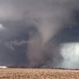
What a day. Intercepted an ongoing wedge tornado at Iowa Highway 92/77 just south of Keota right around 4 PM. After watching it approach for a few minutes (pointing my car ready to blast off if it looked like I was gonna be in the path) the storm cycled right in front of me. A small but intense area of rotation formed out in front of the first tornado, tightening into a truncated cone with a dusty debris cloud whirling below. It quickly became fully condensed, albeit shrouded in dust (almost looking like a clone of Gilmore City, IA from last April, which I missed despite being within striking distance of the storm when it first went severe-warned). These are the two video screenshots included here, thanks to attachment limits.
It then went through a rapid intensification and several changes in appearance, becoming a narrow drillbit which expanded into a dusty stovepipe. An explosion of debris ensued as it impacted some structures while crossing 92 just to my west. @andyhb has seen the screenshot I posted on TalkWeather.As it passed into an open field just to my northwest, the tornado was now a stubby, dusty wedge beneath a ridiculously low-LCL, sculpted tornado cyclone/collar cloud (not unlike some of the April 27, 2011 tornadoes, except this one could actually seen without intervening hills and trees!). The rope out of the first wedge was actually still on-going at this time, I didn't even notice it in real time but captured it by happy accident as the strong inflow wind (to my at-the-time annoyance) panned my camcorder off the new wedge. At this point I realized I'd better move if I wanted any hope of staying with the fast-moving storm.
I blasted east on 92 all the way to IA-1, where I turned north. I pulled over to set up again just after getting through Kalona, but just as I did so the cell began to be affected by surrounding upscale growth. I was able to catch a distant view of the fast-moving rope out from this location.
This is my kind of chasing. No zero-metering for me. If the tornado didn't kill me, either my mother or my wife would.-
 24
24
-


Severe Weather 4-4-23 and 4-5-23
in Lakes/Ohio Valley
Posted
NAM cool bias at play again? Just a real headscratcher how we have some models with hot temps/mixing issues and some with capping issues due to cool temps. It is quite dry at 700mb, though. Although I remember people saying dryness at 700mb was gonna be a problem on the Gilmore City day last April.