

CheeselandSkies
-
Posts
3,247 -
Joined
-
Last visited
Content Type
Profiles
Blogs
Forums
American Weather
Media Demo
Store
Gallery
Posts posted by CheeselandSkies
-
-
00Z WRF-ARW would be...problematic, to say the least across LA/MS. Consistent with its previous (12Z) run. HRRR looks pretty rough too, has uptrended somewhat from earlier runs.
-
20 hours ago, Chicago Storm said:
Maybe down south at some point. Definitely not this upcoming week, though.
Yeah, a couple of those runs with the big western trough hinted at the potential for something more into the Midwest/Ohio Valley region in mid-November (something like 2002, 2005 or 2013) but nothing really came to fruition.
-
On 11/8/2023 at 11:24 AM, CheeselandSkies said:
Possibly some
 potential in there somewhere, as well?
SPC starting to hint at it but exactly when/where/ceiling all still quite uncertain at this point.
*Edit: Just noticed this is yesterday's 4-8, they're waiting quite a bit longer than usual to release today's.QuoteMedium-range guidance is coming into better agreement regarding the potential for a substantial upper trough to move over the West Coast during the latter half of next week. Evolution of this system into next weekend is still uncertain, but this trough could lead to a more consolidated upper pattern across the CONUS, bringing the storm track closer to the low-level moisture. ..Mosier.. 11/09/2023
-
2 hours ago, michsnowfreak said:
BTW you realize cromartie was lying. There is no way he was done raking by mid-October in the 1990s and now not until late-November. I guess somehow magically his leaves fell 2-3 weeks earlier in the 1990s and now fall 2-3 weeks later than they do at a similar climate here in SE MI.
Until someone explained it to me, whenever I would see that name posted I would think of former NFL cornerback Dominique Rogers-Cromartie because that's the only place I'd previously seen/heard that name.
-
 2
2
-
-
18 hours ago, Chicago Storm said:
Solid agreement on deep toughing returning to the West Coast much of next week, as we see a bit of a shake up in the large scale pattern across North America and vicinity. This will lead to another period of very mild temperatures across the sub-forum.

Possibly some
potential in there somewhere, as well?
-
20 hours ago, Geoboy645 said:
This storm was really the first snowstorm I remember somewhat completely. If I recall it had blizzard conditions for a while at Madisn. This is the one that caused the interstate to close between Madison and Janesville, leading to a bunch of people being stranded for quite a bit. It's the reason why there are crossing gates at select interchanges in Wisconsin on the interstates. This storm, the 6/7/08 tornadoes, and the 08 flooding are the events that really got me into weather. I would love a repeat of this storm, without the people being stranded of course.
Yeah, 2008 overall was a balls to the wall kind of year for both
 and in the Midwest. Occurring as they did in my young adult years it and 2010-'11 really upped my expectations for La Ninas which this recent stretch largely did not live up to.
My dad was among those stuck on the Interstate on 2/6, on his way home from work.
-
 1
1
-
-
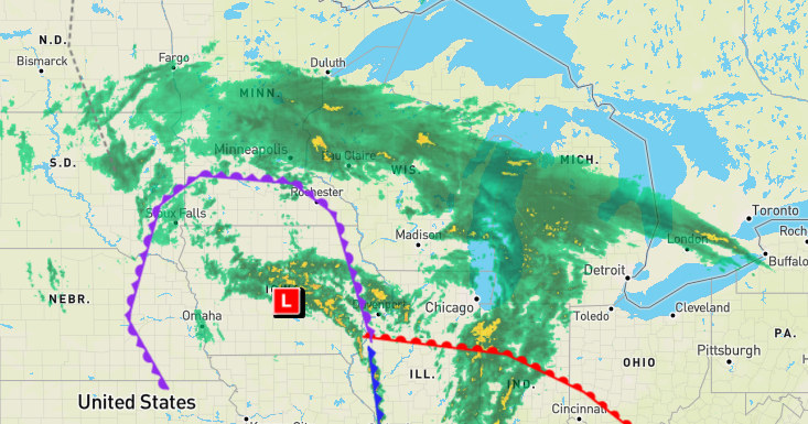
SPC Day 4 highlight for parts of IA/MN/WI. Don't see that in late October too often.
-
22 hours ago, RogueWaves said:
...and beautiful.

-
1
-
2
-
-
Had some interest in severe potential for tomorrow but it hasn't trended too impressively. Has some elements of a classic cold core setup with the moisture tongue getting pulled back into the TP, but just seems like the ingredients are out of phase on the models. All the flow is well out to the east in the warm sector, where there's no CAPE.
-
11 hours ago, Chinook said:
I've been kind of messing around with Tornadoarchive dot com recently, clicking the "random tornado day" feature. Along the way, I rediscovered some interesting days
July 1-3, 1997: a total of 52 tornadoes hit the upper Midwest and into the Northeast, including one in Canada near Detroit. Apparently this was the largest continuous outbreak of tornadoes in the month of July. There was an F2 tornado in the city of Detroit. Not directly associated with a tornado, 5 deaths due to straight line wind at Grosse Pointe Shores MI. Two F3 tornadoes were in Michigan, one was in Minnesota, and one was in Ohio.
June 24, 2003: a total of 67 tornadoes occurred in one day in the "Great South Dakota Tornado Outbreak." Also, a total of 125 tornadoes occurred within a 3-day time span (June 21-24). A single F4 tornado occurred on June 24 and hit the small town of Manchester SD. The residents never rebuilt the city. There were a large number of F0 tornadoes in South Dakota in a couple of counties.
November 22-24 2004: Wikipedia says this was the largest number of tornadoes (104) in one continuous outbreak in the month of November. The worst ones were just three F3 tornadoes in Louisiana and Mississippi. 61 tornadoes were rated F0
That's surprising, considering the extremely prolific (and rather more impactful) outbreak that occurred over several days in November, 1992, tellingly dubbed "The Widespread Outbreak."
Both 2004 and 2005 had quite active Novembers for
(and, of course, extremely active and impactful Atlantic hurricane seasons) despite rather different ENSO states.
They also had quite different springs foractivity. 2004 might still be the best chase season this millennium for anyone who's been chasing that long, if they managed to score the storm of the day on May 12th, 22nd and/or 24th, 29th, and June 12th. 2005 had a mediocre to poor May, although it likewise featured a rather active period in the first half of June. I remember pulling up the University Corporation for Atmospheric Research site (Pivotal Weather didn't exist at the time, and I didn't know about the CoD site) on my dial-up connection and seeing that trough coming in on the 180-hour GFS frame. It still only goes out to 192 hours on that site!
-
1
-
-
Despite meager instability forecast on the GFS, it wouldn't take much for something to happen near that triple point on Friday afternoon. Over E IA/N IL on the 06Z run.
Main issue is and has always with this setup seemed to be the amount of precip the model breaks out across the warm sector.
-
1
-
-
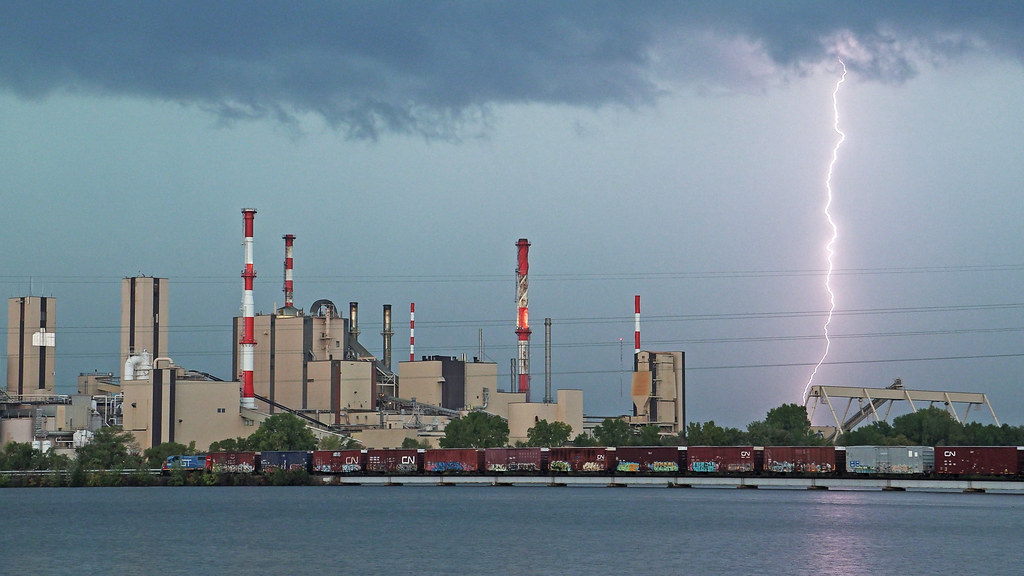
Last Saturday, September 30th I went up to the Wisconsin Rapids area for some railfanning. I neglected to check the forecast, assuming the forecast of sunny for Madison also applied to the rest of Wisconsin. Instead, thunderstorms moved in just as I was arriving, and lingered through the early afternoon. Me and my cameras got drenched, and it took until the mid-afternoon to finally get some nice sun-lit train shots. Consolation prize...
-
10
-
 1
1
-
-
32 minutes ago, OrdIowPitMsp said:
Thank you for confirming how miserable this summer was for me. Couldn’t even get much relief at night.
That's amazing, considering this summer seemed pretty mild with no notable hot stretches (at least none that lasted more than a couple of days) to me in Madison, while Minneapolis, a place I think of as inevitably colder and snowier than us (like Green Bay, but soft, y'know, domed stadium and all), was so abnormally warm.
-
5 hours ago, Chicago Storm said:
hi.
-
2
-
1
-
-
1 hour ago, hawkeye_wx said:
It appears Madison, and much of southern Wisconsin, got a nice soaker overnight.
Yes we did.
-
2
-
-
26 minutes ago, michsnowfreak said:
Its a sign that they got caught in the winds of Hurricane Idalia. Make sure to let us know how they are doing when its 0F out.
Remnants of Idalia didn't come anywhere near Wisconsin. It headed east back out over the Atlantic.
-
On 9/22/2023 at 3:23 PM, TheClimateChanger said:
Brendan used to work at the station I work at in Madison. Great guy.
-
4 hours ago, hawkeye_wx said:
A strong cell passing just nw of Cedar Rapids has been tornado-warned for a while. The sirens have gone off here a couple times, even though CR is not in the path.
Yeah, based on reports/photos that was a legit supercell with a brief tornado. Probably more impressive than anything that will happen in Iowa tomorrow, when it's actually in the tornado risk contours.

-
8 minutes ago, cptcatz said:
18z GFS weenie run bringing a major hurricane into Norfolk at a right angle, front right quadrant going into Chesapeake Bay...
Stalls it right on the coast, too, Florence-style. Yuck.
-
1
-
-
34 minutes ago, A-L-E-K said:
just saw fantasy range nam for iowa...nice
Yikes, that is downright nuts for Iowa Saturday evening.
Late September is the new May?
-
1
-
-
I guess I'll be the one to dust off this thread, since no one else has. Day 4 outlook includes most of Iowa as well as portions of NE/KS/MO. Details/ceiling still pretty up in the air IMO.
06Z GFS also hints at further potential into the following week, but it's pretty much on an island with that.
-
Yep, nice mood rain here tonight. My wife is back in the hospital for the sixth time since last December (we only got married in November of 2021). Unending complications from post-COVID kidney failure. Even if/when she does get a transplant, I'm no longer optimistic that she will recover to anything close to her former self.
-
 12
12
-
-
Whenever some Gen Z'er at work asks me if I'm on TikTok or Instagram, I tell them "It's bad enough I have a Facebook account."That’s why I can’t go on that app. I feel like my brain cells are lining up one by one to off themselves
I had a Twitter account for about a year from 2017-'18, never once regretted deleting it.
#OldFartMillennial
Sent from my Pixel 4a using Tapatalk
-
1
-
-
1 hour ago, Conway7305 said:
GFS continues to show long range storm threat of some sort September 24th. This is the 3rd or 4th run in a row. Unlikely to be correct but worth mentioning.
Yesterday's 12Z Euro: Mega weenie run with Lee.
GFS: Hold my beer.
Winter 2023/24 Medium/Long Range Discussion
in Lakes/Ohio Valley
Posted
Powerhouse on the 12Z/18Z GFS for next Saturday would cause winter wx issues here as well as threat down south. Good times.