CheeselandSkies
-
Posts
3,250 -
Joined
-
Last visited
Content Type
Profiles
Blogs
Forums
American Weather
Media Demo
Store
Gallery
Everything posted by CheeselandSkies
-

2025 Short Range Severe Weather Discussion
CheeselandSkies replied to Chicago Storm's topic in Lakes/Ohio Valley
A miss north for you is a hit for me. -
2025 Short Range Severe Weather Discussion
CheeselandSkies replied to Chicago Storm's topic in Lakes/Ohio Valley
Slight risk out. A state line MCV setup with legs this time? -
2025 Short Range Severe Weather Discussion
CheeselandSkies replied to Chicago Storm's topic in Lakes/Ohio Valley
Wednesday looks potentially interesting, but that could just be me NAM wishcasting again. -
2025 Short Range Severe Weather Discussion
CheeselandSkies replied to Chicago Storm's topic in Lakes/Ohio Valley
SPC vs. 3K NAM...

-
2025 Short Range Severe Weather Discussion
CheeselandSkies replied to Chicago Storm's topic in Lakes/Ohio Valley
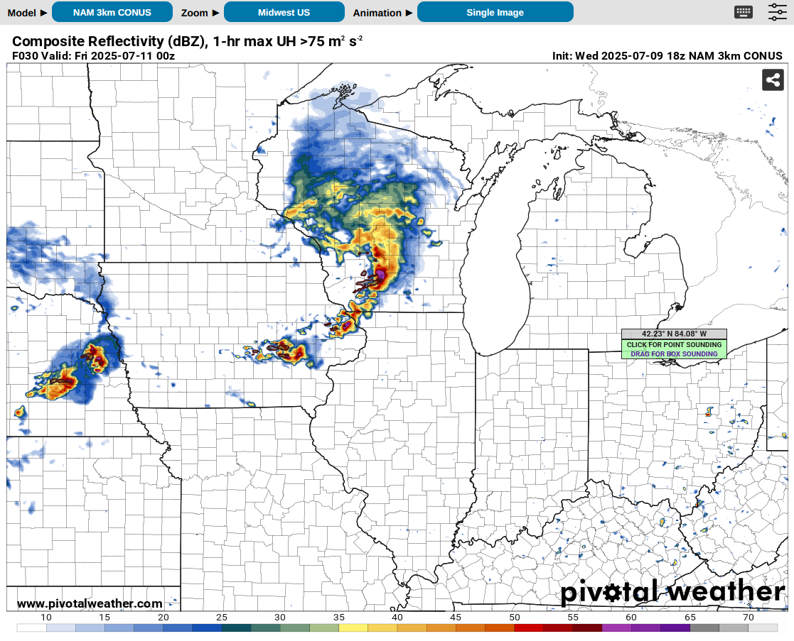
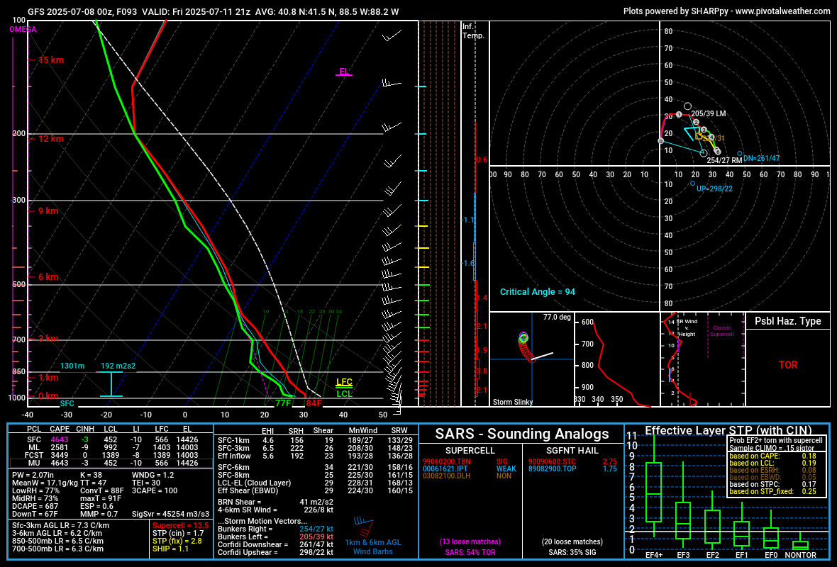
GFS has been somewhat interesting for Friday afternoon/evening around northern IL, although it generates so much precip its hard to get a good handle on what the warm sector might actually look like. Near IL/WI stateline, more hodograph curvature, less instability: Further southeast, near SW burbs. Nice fat CAPE and plenty of 0-3KM CAPE: Those hodographs coupled with the high PWATs suggest HP modes to me, however especially on the second one it looks like the SR inflow might be small enough you can get smaller cells that aren't as rainy as you'd otherwise expect. We've pulled that off around here before on days like 8/9/21.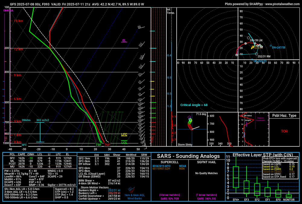

-
First *we'd* need to actually have an MCS over here. Although at least we have been doing pretty decent with the popups around Madison.
-
Yet another meteorologically unremarkable tropical system overperforms in the impacts/fatalities department due to freshwater flooding.
-
2025 Short Range Severe Weather Discussion
CheeselandSkies replied to Chicago Storm's topic in Lakes/Ohio Valley
Kind of annoying that this active Northern Plains pattern hasn't really been able to move east in any meaningful fashion. Time was when eastern SD got tornadic supercells in the evening that meant we'd be getting a bow echo overnight. -
2025 Short Range Severe Weather Discussion
CheeselandSkies replied to Chicago Storm's topic in Lakes/Ohio Valley
Watch out for the western portion of the MCD area. Already a spotter reported tornado in Freeborn County, MN. However CAMS have been less than enthusiastic about today WRT potential robustness of any discrete warm frontal supercells. -
2025 Short Range Severe Weather Discussion
CheeselandSkies replied to Chicago Storm's topic in Lakes/Ohio Valley
Ten years ago OTD. Coal City/Braidwood, IL EF3 along with another EF3 in southeastern Iowa and several EF2s including the one that impacted the Woodhaven Lakes campground near Sublette (hit again, also EF2, during the outbreak of 3/31/23). I would have been able to see that one and the following EF1 in Mendota had they not been completely rain-wrapped.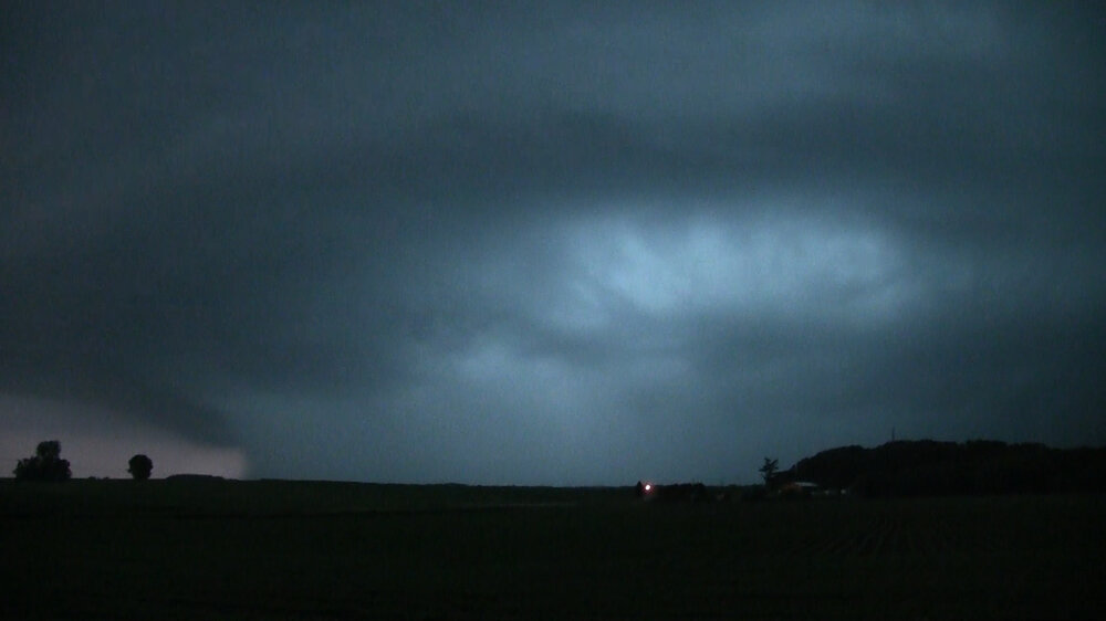
-
That MCV looks like a frickin' landcane on the 12Z 3K NAM. Too bad it can't be coming through 3-4 hours later.
-
*Sigh*. Guess I'll armchair chase an event off to the east after two days of armchair chasing events off to the west.
-
2025 Short Range Severe Weather Discussion
CheeselandSkies replied to Chicago Storm's topic in Lakes/Ohio Valley
I'm actually looking more at Tuesday evening. 00Z NAM moves an organized convective system through a strongly unstable environment in E IA/S WI/N IL Tuesday afternoon with what looks like some potential for supercells along the southern flank of it. These setups are always finicky with timing/placement of subtle shortwaves and associated MCS's which are crucial to determining the existence/placement of any chase-worthy threat. Often can't pin them down until the evening before at the earliest. -
2025 Short Range Severe Weather Discussion
CheeselandSkies replied to Chicago Storm's topic in Lakes/Ohio Valley
Could be looking at some action next week in the northern/western parts of the sub. -
Ugh. Not a fan of this type of warning. "Possible large and extremely dangerous..." "Radar indicated rotation" It's either radar (TDS) or spotter confirmed as being "large and extremely dangerous," or you don't use the PDS designation.
-
I'm curious, at what level are the winds bringing the smoke in? According to the models we should be in southwest flow at 500 with this thunderstorm setup ahead of the incoming cold front.
-
Huh. Unless I was reading it wrong all the social media hype seemed to be for Sunday night.
-
Haven't seen any aurora pictures from MN/WI/IL from last night so I'm guessing the smoke busted it?
-
Bring on angry corn-fueled MCS season.
-
Pleasant, but by my standards too cool and quiescent Memorial Day weekend and most of the remainder of May on tap. If I hadn't gone to get the Arnett last weekend it'd be yet another of those springs where I'd be going stir-crazy.
-
May 17th-20th severe weather discussion
CheeselandSkies replied to Chinook's topic in Central/Western States
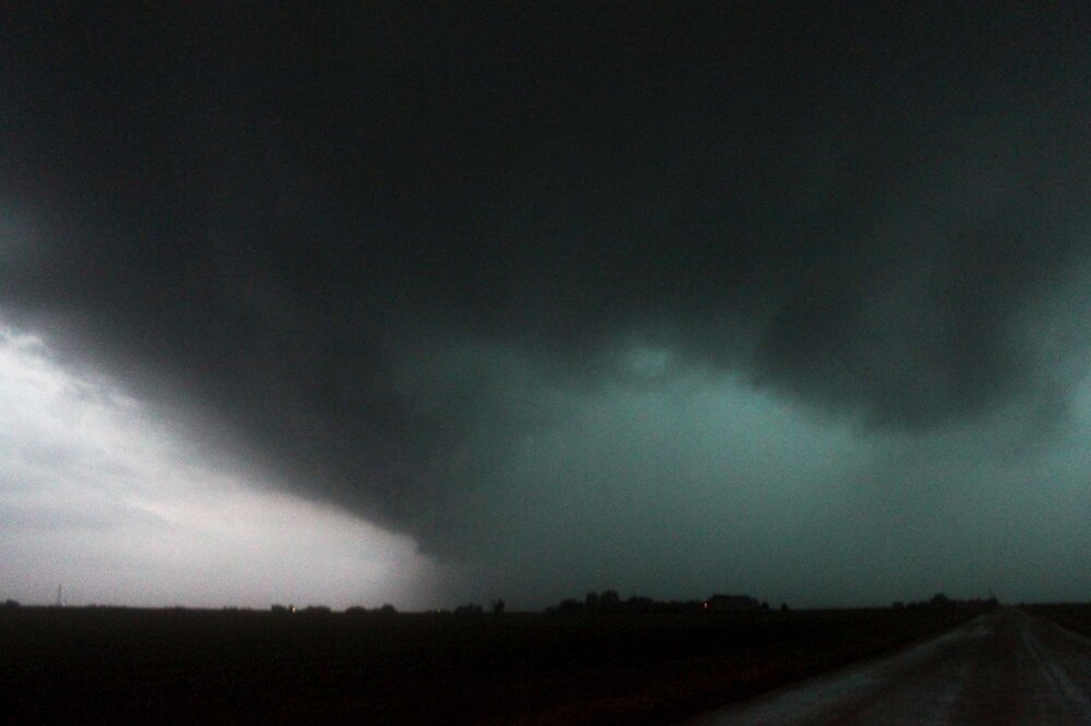
I didn't realize until seeing the DAT that the nocturnal KS beast was actively producing an EF3 while I was on it north of US 54/400 between Cullison and Pratt shortly before 11 PM Sunday. The inflow was howling but the reflectivity signature looked messy from the merger and the velocity, while there was definite rotation, wasn't clear-cut "intense tornado in progress" like it had been back west of Haviland and again from Iuka to Plevna. After I got sick of the pitch black dirt roads (which didn't take very long) and got back on 54/400 eastbound toward Pratt, the lightning didn't illuminate under the base much during the time I was recording. This is the best frame I found that gives some hint as to what was going on, toward the bottom center: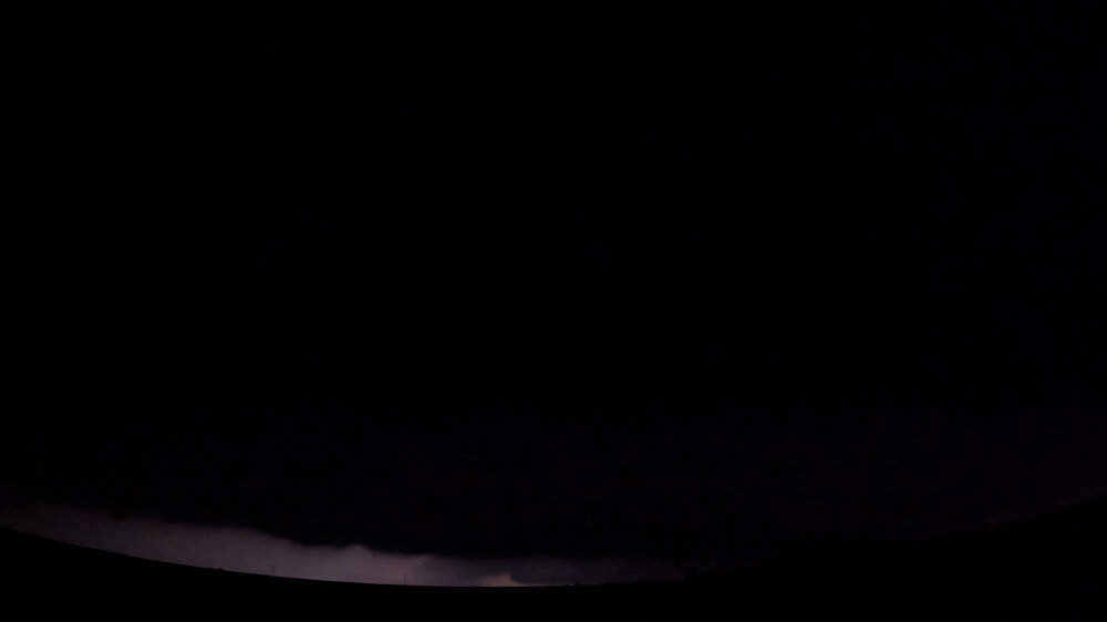
-
May 17th-20th severe weather discussion
CheeselandSkies replied to Chinook's topic in Central/Western States
More fun with timelapsing my Arnett/southern Kansas footage from last Sunday: -
May 17th-20th severe weather discussion
CheeselandSkies replied to Chinook's topic in Central/Western States
Arnett supercell/tornado GoPro timelapse: -
May 17th-20th severe weather discussion
CheeselandSkies replied to Chinook's topic in Central/Western States
Booked PTO to chase this Sunday-Monday back on May 9th. Managed to get there in time for the beauty near Arnett (@andyhb was on it as well). Then, hours after I thought the day was done, tried tangling with the Haviland-Plevna nocturnal beast when it was cycling northwest of Pratt. Quickly thought better of that and booked a room in Pratt for the night just as it was ramping back up. -
A little bit of early day crapvection might have actually helped the threat with this one. So unusual to see such a near-total lack of it with a setup in this region, but now the temperatures are getting too hot, primarily in Illinois where the better chance of a longer-lived discrete mode is.