George BM
-
Posts
3,053 -
Joined
-
Last visited
Content Type
Profiles
Blogs
Forums
American Weather
Media Demo
Store
Gallery
Everything posted by George BM
-
2023 Mid-Atlantic Severe Wx Thread (General Discussion)
George BM replied to Kmlwx's topic in Mid Atlantic
Looks like we have a chance of elevated convection/thunder w/ the main chances coming tonight/early tomorrow morning and again early Friday morning. NW-flow regime... elevated style.- 2,785 replies
-
- 2
-

-
- severe
- thunderstorms
- (and 3 more)
-
This morning the air was uncomfortable for serious running, pre-dawn. Now it's only 5-7F warmer than it was during the 5am hour w/ dewpoints nearly 20F lower w/ the breeze making it feel like September. Overall, a fairly similar day to this past Friday. Currently IAD at 82/49.
-
Yeap. 000 WTNT33 KNHC 202053 TCPAT3 BULLETIN Tropical Storm Franklin Advisory Number 1 NWS National Hurricane Center Miami FL AL082023 500 PM AST Sun Aug 20 2023 ...TROPICAL STORM FRANKLIN FORMS IN THE CARIBBEAN SEA.. ...TROPICAL STORM WATCHES ISSUED FOR THE SOUTH COAST OF HAITI AND THE DOMINICAN REPUBLIC... SUMMARY OF 500 PM AST...2100 UTC...INFORMATION ---------------------------------------------- LOCATION...14.6N 67.1W ABOUT 270 MI...435 KM SSE OF ISLA SAONA DOMINICAN REPUBLIC ABOUT 270 MI...435 KM SSW OF SAN JUAN PUERTO RICO MAXIMUM SUSTAINED WINDS...45 MPH...75 KM/H PRESENT MOVEMENT...WNW OR 290 DEGREES AT 14 MPH...22 KM/H MINIMUM CENTRAL PRESSURE...1002 MB...29.59 INCHES .....
-
That's one advantage of living relatively isolated from others.
-
A little bit of everything for all preferences verbatim.
-
2023 Mid-Atlantic Severe Wx Thread (General Discussion)
George BM replied to Kmlwx's topic in Mid Atlantic
Severe Thunderstorm Watch coming out until 9pm for much of the area.- 2,785 replies
-
- 1
-
-
- severe
- thunderstorms
- (and 3 more)
-
~1.45" in the gauge from yesterday. Brief gusts into the low 40s(mph) w/ the initial line... pedestrian IMBnFY.
-
This got lost in the severe tracking but that 12z GFS run for Friday the 18th was total lolism. Temps in the mid 80s+ at the crack of dawn w/ 110+F highs across the region during the afternoon. OBVIOUSLY 18z is more realistic with no Desert SW-like heat.
-
Going on 270 posts in the severe thread today w/ storms not even in the main region yet. Impressive winter-like activity.
-
2023 Mid-Atlantic Severe Wx Thread (General Discussion)
George BM replied to Kmlwx's topic in Mid Atlantic
IAD up to 89/74. -
2023 Mid-Atlantic Severe Wx Thread (General Discussion)
George BM replied to Kmlwx's topic in Mid Atlantic
Tornado Watch for the region until 9pm. -
2023 Mid-Atlantic Severe Wx Thread (General Discussion)
George BM replied to Kmlwx's topic in Mid Atlantic
It's actually from the same link you shared yesterday. Thanks for that, btw.
- 2,785 replies
-
- 1
-
-
- severe
- thunderstorms
- (and 3 more)
-
2023 Mid-Atlantic Severe Wx Thread (General Discussion)
George BM replied to Kmlwx's topic in Mid Atlantic
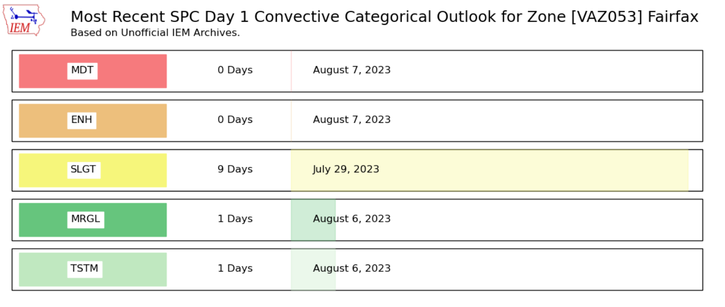
3,707 days. It's been a while.

- 2,785 replies
-
- 4
-

-
-
- severe
- thunderstorms
- (and 3 more)
-
2023 Mid-Atlantic Severe Wx Thread (General Discussion)
George BM replied to Kmlwx's topic in Mid Atlantic
June 13th, 2013.- 2,785 replies
-
- 4
-
-
- severe
- thunderstorms
- (and 3 more)
-
2023 Mid-Atlantic Severe Wx Thread (General Discussion)
George BM replied to Kmlwx's topic in Mid Atlantic
...OH Valley to Mid-Atlantic to the southern Appalachians and Carolinas... Scattered showers and isolated storms are forecast to be ongoing over the OH Valley Monday morning with more widely spaced convection trailing west-southwest into the Mid South/Ozarks. Considerable cloud cover with northward extent over a large moist/warm sector will limit destabilization into portions of PA and north. Farther south, heating of a very moist boundary layer will yield a moderate to very unstable airmass (1500 to 3000+ J/kg MLCAPE) from PA southward into the southern Appalachians. Multiple bands and clusters will likely begin to develop towards midday over the upper OH Valley and central Appalachians. Less certain is convective timing over the TN Valley where a large spread of model solutions is currently depicted. Nonetheless, scattered thunderstorms will likely develop by early to mid afternoon and become quite extensive from northern AL/GA into PA/VA/WV/MD. A mix of semi-discrete cells and clusters are possible initially and a risk for all severe hazards is expected given favorable shear profiles for storm organization/low-level rotation. Upscale growth is expected as storms move into the northern VA/MD and Chesapeake Bay vicinity during the late afternoon/early evening where the wind risk will seemingly be maximized. Much of the activity will eventually move east of the Mid-Atlantic coast during the evening and areas farther south through the Carolina Piedmont and into the coastal plain. Fun sounding disco for this region. -
2023 Mid-Atlantic Severe Wx Thread (General Discussion)
George BM replied to Kmlwx's topic in Mid Atlantic
45% Wind for tomorrow.- 2,785 replies
-
- 2
-
-
- severe
- thunderstorms
- (and 3 more)
-
MJJ ONI: 0.8C (nearest tenth deg) MJJ RONI: 0.33C
-
Where are you now? Northern MD?
-
A band of relatively thick smoke is currently moving overhead. It looks like it's overcast and the sunlight is very dim and orangish.
-
Wow. IAD w/ more than twice that (5.09") just miles away. Hope you get more hits this month.
-
Welcome to the second hottest month of the year. Dewpoints currently in the 50s.
-
Today: Partly sunny early, then clouds increasing late w/ a few showers possible. Record high temperatures expected. High 73. Winds SSW at 15 to 25 mph. Chance of rain 30%. Tonight: Showers and thundershowers early, then a steady soaking rain overnight. Some snow or sleet may mix in late. Low near 35. SSW winds at 10 to 20 mph shifting to NE at 15 to 25 mph. Chance of rain 90%. Rainfall possibly over one inch. Monday: A wind-driven heavy snow throughout the day with blizzard conditions expected. Thunder possible. A morning high of 34 with temps falling into the lower 20s by the afternoon. Winds N at 25 to 40 mph. Snow accumulations of 18 to 24 inches expected. Winds could occasionally gust over 50 mph. Monday Night: Windy. Snow showers early, then skies clearing overnight. Low near 10. Winds NW at 25 to 35 mph. Chance of snow 60%. Snow accumulations of less than one inch.
-
Yeap. Good call. Funny enough it was IAD that would take the triple 98s.
-
2023 Mid-Atlantic Severe Wx Thread (General Discussion)
George BM replied to Kmlwx's topic in Mid Atlantic
Some of you folks probably got verified severe winds(50+kts) from storms two days in a row.- 2,785 replies
-
- 3
-
-
- severe
- thunderstorms
- (and 3 more)
-
2023 Mid-Atlantic Severe Wx Thread (General Discussion)
George BM replied to Kmlwx's topic in Mid Atlantic
Lansdowne and Belmont getting spanked by a microburst(?). Some 60-70mph pixels from TIAD radar there.