
PowderBeard
-
Posts
2,027 -
Joined
-
Last visited
Content Type
Profiles
Blogs
Forums
American Weather
Media Demo
Store
Gallery
Everything posted by PowderBeard
-
At least for me, the Toll House and Mountain Triple terrain really sticks out on this map. Some under rated family and beginner terrain.
-
Belchertown is really weird when it comes to power. Extreme southern end near Ludlow and Bay Rd area seems to lose power any time a squirrel farts while walking the lines. Prior to the past month we had lost power once due to a storm and once they turned it off to replace a pole that was struck in two years. And we have had some very intense thunderstorms and wind. The past month we have lost it 4-5 times. Not sure what is going on.
-
Nam says there will be many a turn earned this weekend.
-
Fixed it...
-
You allowed frost to touch the roof of the Jeep?
-
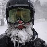
Already have a sick day planned. Powder flu.
-
Appears to be happening in Amherst and all around UMass. Lots of emails on remote classes being canceled/disrupted today.
-
Send It. Quabbin dropped a lot between Friday and Sunday making for an interesting time getting the boat on the trailer without getting wet.
-
Got ya, did not look at a sounding to see what it looked like above.
-
Lincoln Peak (Sugarbush South) reporting 33* at the summit, Glen Ellen reporting 36*. Not sure how Whiteface is reporting 46*.
-
Probably mixing or close to at the top of Sugarbush, Mansfield, and in the Whites.
-
What a mess, intermittent power and internet this morning makes remote teaching fun. A couple folks on the town's FB mentioned a transformers blowing around town.
-
Wednesday, October 7, 2020 Convective Potential
PowderBeard replied to weatherwiz's topic in New England
Some pine damage at a local park just south of us. -
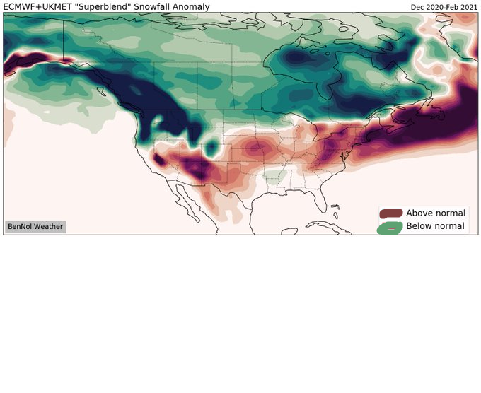
GFS really bringing the cold shot after this week. Euro disagrees.
-
Yup, almost to the day. https://www.masslive.com/news/2015/10/1_year_later_mount_tom_recover.html
-
Tough task. But absolutely, it all made perfect sense.
-
Might have to ask for one for Christmas. I love how he incorporates the terrain so "pods" stick out like at Pico or Sugarbush. One of my favorite maps was the early 2000s Stowe map, then they had to go name everything Upper/Middle/Lower (no disrespect PF, I get why) and cluttered it up. At least there is no "Starr Headwall."
-
Wednesday, October 7, 2020 Convective Potential
PowderBeard replied to weatherwiz's topic in New England
Yea just took a break from grading papers since I couldn't see straight anymore and took a drive. If anyone had a dead oak or weak pine in their yard, good chance it is down. I saw at least 8-9 driveways blocked by large trees. Only a couple of wires down surprisingly. -
Wednesday, October 7, 2020 Convective Potential
PowderBeard replied to weatherwiz's topic in New England
What a mess. Local schools saying "all remote" today yet the majority of town is without power. Trees down everywhere and many roads blocked. Looks like a similar situation for a lot of UMass faculty. Already received numerous emails of cancelations. -
Wednesday, October 7, 2020 Convective Potential
PowderBeard replied to weatherwiz's topic in New England
Had about a 70' dead oak come down in the woods behind our house. That was some serious wind. -
Wednesday, October 7, 2020 Convective Potential
PowderBeard replied to weatherwiz's topic in New England
WTF! Hail, lightning, and roaring winds came in like a wall. 0-60 real quick. -
Wednesday, October 7, 2020 Convective Potential
PowderBeard replied to weatherwiz's topic in New England
When did sunset become 5:05? Damn -
Wednesday, October 7, 2020 Convective Potential
PowderBeard replied to weatherwiz's topic in New England
Gone severe. Thunder rumbling. -
Wednesday, October 7, 2020 Convective Potential
PowderBeard replied to weatherwiz's topic in New England
Ha! As does my wife's. Could be interesting. Steady 15-20mph breeze. Looks like down the road had a gust to 37. -
Wednesday, October 7, 2020 Convective Potential
PowderBeard replied to weatherwiz's topic in New England
Yea, trying to work or have school remotely with no power/internet for days is a bit tricky to say the least.


