-
Posts
1,131 -
Joined
-
Last visited
Content Type
Profiles
Blogs
Forums
American Weather
Media Demo
Store
Gallery
Everything posted by WesternFringe
-
GFS and RGEM and the Euro keep showing the most snow where Augusta, Albemarle, and Nelson counties meet. Wintergreen should have some powder, PSU, but maybe too small for you? I live in Augusta nw of the current bullseye, but in the game for an inch or two unless we get a NW bump (towards the 18z NAM dare I say)
-
Bullseying me NNW of Staunton so it must be right.
-
Snowing very very lightly here northwest of Staunton.
-
Late January and February Medium/Long Range Discussion
WesternFringe replied to WinterWxLuvr's topic in Mid Atlantic
Yeah, this one seems to be getting away from me over on the other side of Afton Mountain from you as well. Like PSU said, the second wave is the more interesting one anyways!- 4,130 replies
-
- 1
-

-
- prime climo
- cold canada
-
(and 1 more)
Tagged with:
-

Late January and February Medium/Long Range Discussion
WesternFringe replied to WinterWxLuvr's topic in Mid Atlantic
This year, the ops are leading the ensembles at 5 days out* *special 21-22 winter weenie rule- 4,130 replies
-
- 1
-

-
- prime climo
- cold canada
-
(and 1 more)
Tagged with:
-

Late January and February Medium/Long Range Discussion
WesternFringe replied to WinterWxLuvr's topic in Mid Atlantic
- 4,130 replies
-
- prime climo
- cold canada
-
(and 1 more)
Tagged with:
-

Late January and February Medium/Long Range Discussion
WesternFringe replied to WinterWxLuvr's topic in Mid Atlantic
Per the GPS, NW of Staunton I am fringed on snow and sleet and expecting .35" qpf of freezing rain (which verifies as often as I hit the Powerball). Can I pass? eta: I hope northern areas that have been fringed earlier this winter get destroyed with snow, and ice (if you like ice)- 4,130 replies
-
- 2
-

-

-
- prime climo
- cold canada
-
(and 1 more)
Tagged with:
-

Late January and February Medium/Long Range Discussion
WesternFringe replied to WinterWxLuvr's topic in Mid Atlantic
You are a bundle of joy! eta: I am digging the GFS. Back-to-back ice storms, a little snowstorm on the 10th, a little snow on the 13th, and another wave approaching at the end of the run. Hopefully another model or ensemble latches on to one of these threats and gives us something to legit track!! Hard to be pessimistic here as I just had 28.5" in January when my climo is 24" for the season- 4,130 replies
-
- prime climo
- cold canada
-
(and 1 more)
Tagged with:
-

January 28-29 2022 Miller abcdefu Storm Obs/Discussion
WesternFringe replied to mappy's topic in Mid Atlantic
Ended up with 3” of powder here NW of Staunton. ETA: pictures are right side up now -

January 28-29 2022 Miller abcdefu Storm Obs/Discussion
WesternFringe replied to mappy's topic in Mid Atlantic
28/27 NW of Staunton 3-4” of fluff out of nowhere amazing -

January 28-29 2022 Miller abcdefu Storm Obs/Discussion
WesternFringe replied to mappy's topic in Mid Atlantic
36/27 Light Snow in Staunton -

January 28-29, 2022 Miller abcdefu Storm Threat
WesternFringe replied to WxUSAF's topic in Mid Atlantic
You just can't help yourself Just playing- I appreciate the pbp! -

January 16-17, 2022 MLK storm obs/now cast
WesternFringe replied to George BM's topic in Mid Atlantic
16 degrees and heavy snow. 8” and counting! The globals (euro and GFS) kicked the mesos ass so far here -

January 16-17, 2022 MLK storm obs/now cast
WesternFringe replied to George BM's topic in Mid Atlantic
-

January 16-17, 2022 MLK storm obs/now cast
WesternFringe replied to George BM's topic in Mid Atlantic
16 degrees NW of Staunton. About 4”. Picnic table is under a pergola -

January 16-17, 2022 MLK storm obs/now cast
WesternFringe replied to George BM's topic in Mid Atlantic
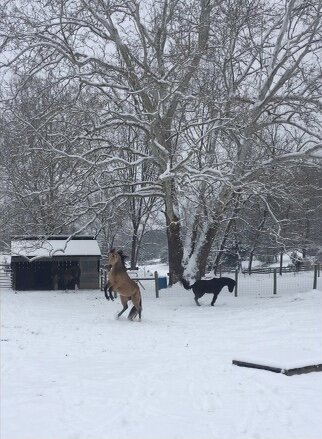
Moderate to Heavy snow. 3-4” otg. NW of Staunton ETA: This was earlier when there was only an inch. My wife spent hours making sure their stalls were comfortable, but they prefer Jebwalks and hay! -

January 16-17, 2022 MLK storm obs/now cast
WesternFringe replied to George BM's topic in Mid Atlantic
It has started earlier than forecast here. The thump is incoming 16 degrees and steady, light snow. Beautiful. About 1/2”. NW of Staunton -

January 16-17, 2022 MLK storm obs/now cast
WesternFringe replied to George BM's topic in Mid Atlantic
Steady light snow here NW of Staunton. 18° -

January 16-17, 2022 MLK storm obs/now cast
WesternFringe replied to George BM's topic in Mid Atlantic
16/6 here in Churchville area (NW of Staunton). Friend of mine just reported seeing first flakes at Wintergreen about 20 minutes ago. eta: First flakes here too! I had to go outside to notice because it’s super light. But it’s snow!! -

January 16-17, 2022 MLK storm obs/now cast
WesternFringe replied to George BM's topic in Mid Atlantic
After that, head on up to Intercourse, PA and do the whole trip over again. -

January 16-17, 2022 MLK storm obs/now cast
WesternFringe replied to George BM's topic in Mid Atlantic
23/12 here NW of Staunton -
I will take my 14” and run. If only that were to verify!
-
Hoping for some late bumps east to the projected track of the low today to make this event better for everyone in the sub. Still looking like a nice storm out here imby NW of Staunton. Latest Euro drops 14”. GFS was 10-12”. NAMs do give me some pause, and I expect to mix some towards the evening, but even the last 3k I looked at had 5-6” of snow before ice afterwards. I hope this storm overperforms and everyone in here is pleasantly surprised! And thanks for all of the analysis and laughs along the way. This has been a helluva roller coaster thread, and fun to be a very small part of it.
-
Not where I live

