WesternFringe
-
Posts
1,131 -
Joined
-
Last visited
Content Type
Profiles
Blogs
Forums
American Weather
Media Demo
Store
Gallery
Everything posted by WesternFringe
-
Remember a couple pages back when we had a KU on the longe range GFS and snow maps were allowed bc it is Christmas? Those were the good old days. Merry Christmas and Happy Holidays, all!
-
When it snows for hours in the morning and hours at night driving around, it is super pretty and makes it feel like winter and is exciting to me. I grew up in upstate NY and had lots of days with flurries like that. Even without accumulation, snow can be fun. I record every time something frozen falls from the air in my logbook on my phone, like on 12/18 when we had flurries off and on all day and driving at night looked like hitting warp speed in the sci fi movies. It was awesome!
-
I never gave up on this window. We would gladly take another 3” wet snow storm out here. Counting days with legit flurries, this would be the 5th time it has snowed in a month if it verifies, which has already been more snow than last year! That said, I would rather this be a 3” snow for the whole subforum with entrenched cold in place, but alas the weather doesn’t care what I prefer.
-
I teach HS math, like algebra, geometry, calculus, stats, etc. In my 21st year. I have my PhD and should go teach preservice teachers in college, but I just really love teaching high schoolers.
-
I forget, is it you or Stormchaserchuck that said mushrooms are better than weed? Just kidding, and I know you know more about longwave weather than I do, but I don’t always understand what you mean. 12Z shows what the ensembles hinted at which is a lottery snowfall potential for some in our sub late next week. Likely favors NW and elevation as temps and lift dominate the snow equation
-
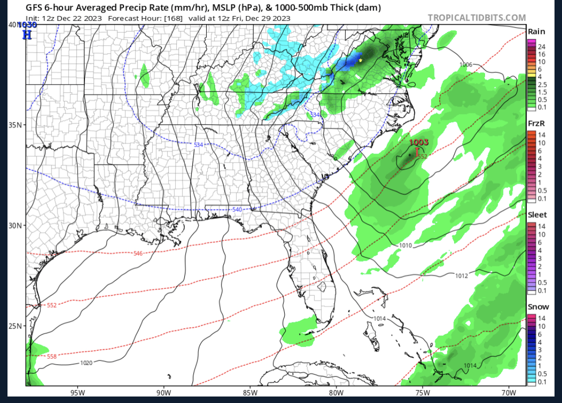
Gives me 3-4” and PSU similar, which, I am reading bodes well for winter overall for the subforum! ETA: I know that the GFS, even if right about snow developing, very likely will not nail the location at 174 hrs, but this tells me maybe someone in the forum has a chance for a quick shot of pouring snow

-
Weather app on my phone is showing snow for us with elevation in Augusta County that day. Will be keeping an eye on that storm. Self-
-
6
-
So, instead of 22 at night it might only get down to 25? Oh no! Also, using ensemble means for accurate temp forecasts at hr 276 is funny bro.
-
Flurries for the 2nd time today in Augusta County NW of Staunton. 32 degrees. Looks like I was traveling through a galaxy filled with stars when driving just now.
-
The mountains there form a tight U-shape with Sherando tucked in the middle, so it gets upslope from pretty much any direction a storm approaches from.
-
There’s like a whole other thread for this and stuff
-
All the debs who doubt the ensembles overall 500 depictions 10-14 days out are often the same folks that think models’ projected temps must be 100% accurate from 10-30 days out.
-
The ICON storm we were discussing was on 12/19. You were saying the timing didn't matter because there was no cold to pull from, but there is cold forecasted during that timeframe.
-
No cold air?
-
Wrong. If we get a dynamic enough 850 pass, it will pull cold air from aloft and north and we will have ourselves some snow
-
It literally worked Monday morning for many in the forum.
-
Even though I am the one that posted about temps, I fully agree with you. It is nonsense all the talk about snow chances being doomed because it is warm 5 days before an event or that weeklies showing 1-2 degree AN mean no snow chances for that entire week.
-
Just to clarify, I wasn’t trying to say we are in an arctic blast good winter weather pattern, but rather that all the doom and gloom torch comments based on weeklies hasn’t panned out here at least. My area is only about 2 degrees higher than the December average and we haven’t made it yet to the second half of the month which tends to be colder than the first half obviously. In the end, I think there is a decent to good chance that December ends up being very very similar to previous Decembers wrt average temps here in Augusta County. Admittedly, I don’t follow metro temps closely, but given the latest guidance from the ops I would not be surprised to see DCA within a degree of normal when averaged at the end of the month. Time will tell.
-
Wait, I thought December was already declared a torch and a sea of warm based off of the weeklies a couple weeks ago!?! In reality, so far December has produced snow for many in the sub-forum and it feels pretty cold with lows in the low 20s and highs in the 40s here this week with more of the same on the way over the next week plus.
-
Again, 2-3 degrees warmer than average isn’t warm in late December. And what does the 2 degree departure from average over an entire week have to do with discrete snow chances? What were the average temp anomalies for the week where I just got 2.7” and much of this board got 1-4”?
-
Ended up with 2-3" on the ground before the melting started. Enough for a 2-hr delay!
-
-
And lots of regular snow!
-
Just hearing thunder snow for the first time south to north